Intro2

III. Geopolitical Background

The Anglo-American Settlement of the Trans-Appalachian West

Introduction


     The Anglo-American expansion into the trans-Appalachian west took place within a geopolitical framework defined by Native American aboriginal tribes, who already occupied the North American continent, and European colonial powers, who were attempting to gain control of the same ground. While both of these contestants competed with each other for territorial control, neither was a homogeneous unit. Not only did they battle each other for control of North America, but both Europeans and Native Americans consistently warred among themselves. The European story is a saga of the continuation of a centuries-old struggle for supremacy of the European continent transferred across the Atlantic Ocean to North America. Likewise, the Native Americans were divided along linguistic/ethnic lines, and struggled with each other for territorial control. 


    Anglo-American here refers to the, mostly, English-speaking European colonists of eastern North America, whose ancestors (or themselves) originated from various parts of the British Isles. The term Trans-Appalachian West is here used to define the territory west of the chain of mountains, known as the Appalachians, that arc across eastern North America in a northeast/southwest direction. Eastern North America can be divided, topographically, into several regions based on regions of similar terrain. The eastern side of the mountains encompasses the Piedmont and the Coastal Plain Geomorphic Provinces. The Piedmont is an area of broadly undulating, low, rolling hills, interrupted by occasional mountainous knobs, which, seaward, gradually merges into the flat topography of the Coastal Plain. Major streams on the eastern side of the mountains are generally oriented at right angles to the mountain front, and drain more or less directly to the Atlantic Ocean. The mountains, themselves, are composed of two parts: the Ridge & Valley and the Blue Ridge Provinces. The latter province is a very narrow band of mountainous ridges that rise abruptly from the Piedmont and becomes increasingly wider to the south and west along the trend of the mountain chain. The Ridge & Valley Province, on the other hand, which lies immediately westward of this province, constitutes a series of mountainous uplifts alternating with broad valleys. Most of the streams in this region flow down these valleys and generally parallel the curving axial spine of the mountains. With easy access westward into the center of the continent being blocked by the mountains, it was primarily along these valleys, paralleling the trend of the mountains, that Anglo-American settlement progressed - going around the mountains rather than directly across, although there are several distinctive gaps. To the west of the Appalachian mountains, along the eastern side of Lakes Ontario and Erie then along the Ohio River and southward, lies the Allegheny Plateau, a region characterized by lowlands sprinkled with escarpments and low plateaus. The overall drainage pattern west of the mountains is defined by the St. Lawrence River/Great Lakes system to the north and the Ohio/Mississippi River drainage system to the south, so, unlike the eastern side of the mountains, all of the streams that drain the mountains flow into major continental river systems rather than directly into the ocean. This portion of the report focuses on the geopolitical forces affecting Anglo-American expansion across the southwestern flank of the Appalachian mountain chain. These, mostly English-speaking settlers populated the lowlands of the Allegheny Plateau between the Tennessee and Ohio Rivers, essentially, the area that forms much of the modern-day states of Kentucky and Tennessee (Figure 31).28,31,311

The Native Americans

   The first Americans originated as Asian and Mongol hunting groups who left their homelands, possibly driven by hunger, warfare or a combination of these and other factors. Relying upon hunting for food, they most likely followed herds of migrating prey across a newly-exposed land area known now as the Bering Land Bridge (Figure 52), connecting the Asian and North American continents. Today, as throughout most of it's existence, this land area lies below sea level, blocking such a migration. However, a series of glaciations had recently engulfed the planet, and, in the process, large amounts of water had been transferred from the sea onto the continents in the form of glacial ice. Withdrawal of such a huge amount of water from the ocean caused a significant drop in the sea level (up to 300 feet), exposing vast tracts of continental shelf bordering the continents. The term land bridge is somewhat misleading, since the exposed continental shelf area along the Bering Straits was 1,000 miles wide. An exchange of flora and fauna was, thus, made possible between two previously separated land masses. Before long, ecological niches and habitats throughout both American continents became populated with a very successful invasive species - Homo sapiens. As the climate warmed, the glaciers receded and sea level rose, effectively cutting off the Asian/American connection, which left the newly resident human population to develop in isolation for thousands of years.32,49,126


   The primary habitats capable of supporting a hunting and gathering lifestyle in North America were plains and woodlands, and to a much lesser extent, deserts. The Eastern Woodlands constituted the, mostly forested, land of eastern North America, extending from the Mississippi River to the Atlantic Ocean and from the Gulf of Mexico northward past the Great Lakes area. These woodlands were full of large and small game, such as bison, deer, elk, bears, turkeys and rabbits, which suited hunting societies quite nicely. The natives also developed agricultural techniques, growing such domesticated native plants as corn, beans and squash to supplement their hunter/gatherer diet of meat, nuts and berries. These occupants of the Eastern Woodlands were characterized by two linguistic groups. Generally, there were Algonquian speakers in the north and Siouan speakers to the south, although the Siouan speakers had been advancing northward over the centuries leading up to the time of European contact. Actually, there were up to six discrete Native American linguistic groups in North America, each, of which, is believed to represent a discrete wave of immigration across the Bering land bridge. Among the Algonquian speakers were the Delaware, Ojibwa, Ottawa, Shawnee (Shawanoe) and Algonquin tribes. Siouan speaking tribes of this region included the Choctaw, Chickasaw, Creek, Iroquois and Cherokee. Thus, natives of the Eastern Woodlands of North America constituted a diverse collection of people with distinctive languages and varied customs. Communication between and among the groups assisted in the development of some commonalities, but also inevitably led to conflict. Warfare between tribes typically constituted low level activities centering quite often on competition for trade and hunting territory, and usually consisted of limited raids and ambushes, revenge for insults, injuries or deaths and the taking of slaves. Full-scale warfare, however, although not particularly common, was not completely absent. In the trans-Appalachian west, the major Native American players were the Siouan-speaking Cherokee and Iroquois and the Algonquian-speaking Shawanoes.49,50,51,52,53,126


   The Iroquois formed a powerful confederation of exclusively Siouan-speaking groups, known as the Iroquois Confederacy, that controlled western and northern New York, and were the major Native American ally of the British in the north. Due to their position between the main French and English colonies, the Iroquois traded with both, although the French alignment with their Algonquian-speaking enemies served only to alienate the Iroquois and French. The trading partnership tremendously benefited the Iroquois, and manufactured goods, such as metal knives and bowls, tomahawks, tools, blankets and beads greatly improved their standard of living. In return for these items, the Iroquois supplied mammal furs, of which, beaver pelts were, without a doubt, the most valuable. Relentless mining of this natural resource, however, soon resulted in a depletion of the beaver population throughout Iroquois-controlled lands, and this fact, combined with their increasing dependence on a trade-improved lifestyle, led the Iroquois to expand their range by means of conquest. Of equal importance to the manufactured household-related trade goods were muskets, powder and ammunition, and, being in a position to control the flow of traded European firearms, the Iroquois became armed with the most sophisticated and technologically advanced weaponry of the day. Their Native American enemies remained in the Stone Age as far as armaments were concerned, which gave a decided advantage to the Iroquois. From 1630 to 1700 a series of conflicts, known as the Beaver Wars, was instigated and pursued by the Iroquois Confederacy. Their successful expansion at the expense of the existing inhabitants led to the virtual depopulation of Indiana, Ohio, Kentucky, lower Michigan and western Virginia and Pennsylvania during this time period. In what amounted to a 17th century, Native American version of ethnic cleansing, the Iroquois conquered and assimilated nearly all Iroquoian-speaking tribes in the area, and expelled or killed all Algonquian speakers. For the next 70 years, the entire region was, for the most part, uninhabited and served, essentially, as a private game reserve for the Iroquois. Being depopulated of humans, the game naturally increased tremendously in this region, which served one of the overall aims of the Iroquois expansion.60,65,66,67,68,71,87,97,115,126


   At the time of their first contact with Europeans in 1540, the Cherokee were a somewhat settled society occupying about 200 moderately sized villages throughout Kentucky and Tennessee, the western part of North Carolina, South Carolina and Virginia, as well as northern Georgia and Alabama (Figure 53). Contact with the British Carolina colonies eventually developed into a brisk trade exchanging, among other items, deer skins and slaves (mostly Native American women and children) for firearms, manufactured goods and whiskey (Figures 53 and 54), and dependence on this trade relationship placed them firmly in the British camp. Prior to the arrival of the Europeans, the Cherokee carried on almost constant warfare with the neighboring Chickasaw, Creek and Catawba tribes, although the level of violence was raised tremendously when the fur trade introduced firearms into the mix. Early in the Beaver Wars, the Shawanoes had been pushed from their homelands in southern Ohio, western Virginia and western Pennsylvania, and dispersed into several distinct groups. One group headed east, another west, and the Cherokee took in two other groups. One Shawanoe group was directed to the Cumberland valley to serve as a buffer against the Cherokee enemy, the Chickasaw. The other group was sent to the eastern Carolinas to serve as a buffer against the Catawba. Not surprisingly, the Shawanoe battled both the Chickasaw and Catawba, and even, eventually, fought with their hosts, the Cherokee. In 1692, the Cumberland Shawanoes attacked a defenseless Cherokee village on a slave raid, which earned the undying enmity of their hosts. Matters simmered for awhile, but by 1715 the Cherokee entered into an alliance with their archenemies, the Chickasaw, against the Shawanoes. They inflicted some severe defeats, but the Shawanoe remained in the Cumberland River Valley. In 1745, the Cherokee and Chickasaw again allied against their common enemy, this time driving the Shawanoes out of the area entirely. By the mid 1740's, the various dispersed Shawanoe groups had either been forced, as in the case of the Cumberland Shawanoe, or drifted back on their own to their homeland north of the Ohio River, establishing permanent villages (rather than temporary hunting camps) from central Ohio to western Pennsylvania.61,126,130


   By the late 1740s and early 1750s on the eastern end of their territory in the Carolinas, the Cherokee were losing ground to encroaching British colonists. Up to this time the Cherokee had been fairly staunch allies of the British, but this gradual loss of land severely tested this relationship. They considered a shift in alliance to the French for awhile, but the French trade goods were more expensive and of lower quality, not to mention the fact that their supply line was often interrupted by British blockades during times of war. All of these factors eventually mitigated against any political shift. The British, however, were aware of this potential change in allegiance, and made great effort to maintain the Cherokee in their fold. An incident in 1759, however, quickly spun the entire situation out of control. On a joint military campaign with Virginia militia against the Ohio Shawanoe, the Cherokee lost their supplies during a dangerous river crossing, and were abandoned by their Anglo "allies". Angry over the treatment, the Cherokees re-supplied themselves from the Virginians, which was followed by a bloody reprisal. The violence escalated with a series of retaliatory raids against outlying British settlements, and equally bloody raids on Cherokee villages. By the end of 1760, regular British forces, now available since the French had finally been defeated, were deployed. They proceeded to destroy the food supply for 15 Cherokee towns, so, faced with starvation or continued war, the Cherokee sued for peace in 1762.126,130


The Europeans


  From their beginnings in the late 1500s and early 1600s, through the mid 1700s, European colonial settlements in eastern North American were engulfed in a great power struggle among their founding nation states. Back in the old world, each mother country for centuries had sought to prevent the other from controlling all or most of Europe, while, at the same time, attempting to establish their own hegemony. As they became colonial powers and extended their reach around the globe, European wars spawned by this competition rapidly escalated into 17th and 18th century versions of world wars. Not only did the combatants prey upon each other in Europe, but they also raided their opponents' colonial holdings in India, the Americas and the South Seas. While Great Britain, France, Spain, Sweden, Holland and Russia competed with each other for control of various parts of the North American continent, by 1760, the English were the only European power of any consequence in the Appalachians and Great Lakes region. Spanish territories lay in the American west and southwest; Russia controlled only some coastal lands in the Alaskan region; French holdings had been reduced to what would eventually become the Louisiana Purchase, and both Sweden and Holland had abandoned their North American colonies. (Figure 54). For the one hundred and sixty-some year prior to 1760, however, the main European competition for eastern North America had been between England and France.25,26,28,31,42


   Settlement of the North American continent by both countries (France and England) initially developed in an effort to serve the fishing fleets in the waters off present-day eastern Canada and New England. As this industry developed, so did a thriving traffic in fur trading on the North American continent, with European markets driving the development of both industries. From it's early 1600s beginnings in Montreal and Quebec, the colony of New France eventually developed into a vast territory, encompassing nearly all of the drainage basins of the Mississippi and St. Lawrence Rivers, extending from the St. Lawrence Seaway to the mouth of the Mississippi River and from the Appalachians to the Rocky Mountains. British colonies around the Hudson Bay and along the Atlantic seaboard down to Florida (which was Spanish territory throughout much of this time), flanked New France. While the Ohio and Mississippi drainage basins west of the Appalachians were claimed by both France and England, they were occupied by Native Americans. Although there were exceptions, for the most part, the Siouan-speaking tribes, such as the Iroquois and Cherokee, were British allies, while the Algonquian-speaking tribes became allies of the French. While New France eventually comprised a vast area, it was thinly populated, and, unlike their English counterparts, it was far from being self-sufficient. The 13 individual English colonies along the Atlantic were densely populated, confined to a fairly narrow corridor between the Appalachian Mountains, the Atlantic Ocean and Florida and were, for the most part, self sustaining agricultural and industrial enterprises. After about 160 years of development, the entire French population of New France in 1754 consisted only of about 55,000 people, while the English seaboard colonies numbered upwards of 1.5 million people. With available land decreasing and an already large population expanding, it was only a matter of time before Anglo settlers began to spill over into the sparsely settled and poorly defended lands west of the Appalachians.25,26,28,31,42


   From 1689 through 1763, a series of armed conflicts, collectively referred to as the French and Indian Wars (Table IX), occurred between the English (along with their colonists and Native American allies) and the French (along with their colonists and Indian allies), and to a lesser extent - the Spanish. Except for the Seven Years War, all of these conflicts began as European wars that later spilled over into the colonies. In that war, the situation was reversed with a colonial war sparking a war on the continent. During this time period, the settlers along the frontiers of the French and British colonies experienced a fairly continuous state of armed conflict. The character of the wars in North America, however, were quite different from the European experience. Rather than pitched land and sea battles between standing armies and navies, which was the norm in Europe, the North American equivalents of these conflicts were chiefly characterized by the hit and run tactics of guerilla warfare, consisting, chiefly, of bloody and violent raids and counter retaliations between settlers and the Native American allies of the European powers, although there certainly were instances of regular troop engagements and naval activity. Both sides, through necessity, used their Native American allies to attack and terrorize the settlers of the opposing side in a 17th and 18th century version of state sponsored terrorism.24,26


Table IX

The French and Indian Wars


Colonial War

Time Range

European Equivalent

King William's War

1689 - 1698

War of the League of Augsburg

Queen Anne's War

1702 - 1713

War of Spanish Succession

King George's War

1744 - 1749

War of Austrian Succession

French and Indian War

1754 - 1763

The Seven Years War


      King William's War began when England joined a European alliance composed of Spain, the Netherlands, the Holy Roman Empire and several smaller German states in an effort to prevent French territorial expansion on the European continent. In North America, the French had been expanding their claim on the Mississippi valley by building a series of outposts in the Mississippi basin and Great Lakes region and encouraging settlement. The only formal military action by the British during the war was a failed attempt to take Quebec, the capital of New France. Numerous pro-British Iroquois raiding parties attacked remote French settlements and combined French, Huron and Algonquin war parties raided outlying English settlements with most of the fighting occurring in the northern English colonies. The Treaty of Ryswick ended hostilities in 1697, but the results were inconclusive. All captured territories were returned, and shortly after the armistice, the French resumed their activities in the Mississippi basin and Great Lakes region, further fanning English fears of French domination of North America.16,17


   A few years later Queen Anne's War flared up when the Spanish monarch passed away without leaving an heir. When the French king claimed the Spanish throne, England declared war against both France and Spain and fighting broke out again. In North America, the nature of the war varied significantly as a result of the actions of the Native Americans. In the northern colonies, formal military actions and border raids continued as they had in the previous war. The middle colonies, centered around New York, were buffered from the French by the Iroquois Nation. Being in a weak state from their recent expansion during the Beaver Wars (previously discussed) and suffering from a devastating bout with smallpox, the Iroquois remained neutral. As a result, active trade between the middle English colonies and the French continued throughout the war. The southern English colonies were surrounded by hostile forces, since England was aligned against both France and Spain. The Spanish in Florida and French at the mouth of the Mississippi were powerful checkmates to English colonial expansion, but inconclusive military campaigns and the strength of the Creeks and Cherokees, who occupied the lands between the Mississippi River and the Atlantic, prevented significant territorial gains for all sides. The Treaty of Utrecht formally ended hostilities in 1713. In the agreement, France turned control of Newfoundland and Acadia (Nova Scotia) to England in order to retain control of the Spanish crown, although they were forced to promise never to unite France and Spain. While the British made overall gains in the war, at least in the north, the French were far from defeated, and used the following period of relative peace to continue strengthening their control of the Mississippi valley, as well as their last remaining northern stronghold - the fortress of Louisbourg on Cape Breton Island.14,37


   In 1744 the death of the Austrian Emperor led to more succession disagreements that inevitably resulted in war. In North America this became known as King George's War. England and the Netherlands lined up against France, Spain and others, and, in the American colonies, murderous raids upon outlying settlements of both the French and English continued as in previous wars. While the French stronghold of Louisbourg was taken by the English colonists, the Treaty of Aix-la-Chapelle, which ended the war in 1749, returned it to France in exchange for French territorial concessions elsewhere. In the American colonies, the results of latest war were, again, inconclusive, and both England and France still vied for territorial control and dominance of the lucrative fur trade in the Ohio River valley. By this time, the French had built a series of fortifications from New Orleans to Quebec in an attempt to firmly fuse the northern and southern portions of New France. Conspicuously missing, however, was a strong line of fortifications south of the Great Lakes and along the Ohio River. A series of actions and retaliations quickly ratcheted up the heat and tempo of activities, ultimately resulting in the finale of the French/British competition - the Seven Years War.4


   Shortly after the latest war, English claims on the region west of the Appalachians began to materialize in a series of land grants from the English monarch to wealthy and powerful Virginia landowners and politicians. In 1748 the Ohio Land Company received a grant of 500,000 acres in the forks of the Ohio (where the Ohio River formed from the merging of the Allegheny and Monongahela Rivers) with a mandate to build forts, as well as to encourage settlement and foster land speculation. A year later the Loyal Land Company received a grant for 800,000 acres located west of the Blue Ridge, north of the border with the North Carolina colony and south of the Kanawha and Ohio Rivers. Explorations of the latter grant led to the Anglo-American discovery of the Cumberland Gap - one of the openings across the Appalachian Mountains through which the Anglo-American settlers would eventually stream into the trans Appalachian west. In addition, the Greenbrier Company obtained a grant for 100,000 acres in the Greenbrier River region of western Virginia, and several trading posts were set up in Ohio by Pennsylvania interests.14,38


   All of these activities encouraged Anglo settlers and traders to begin filtering into the region, which greatly alarmed the French. Beginning about 1754, raids on the trading posts by Native Americans (mostly members of the Ottawa and Chippewa tribes accompanied by French military advisers) were followed by hurried construction of French military outposts in western Pennsylvania. This, in turn, prompted an unsuccessful campaign by the Virginia militia into the forks of the Ohio. In 1755, disgusted by what they considered to be ineffective and unprofessional local militias, regular British forces were dispatched to counter the French challenge in a multi-pronged attack against Louisbourg, several French forts in upper New York and in western Pennsylvania. French forces, in most cases accompanied by their Native American allies, soundly defeated each army. Sensing a French victory in this grand contest, Native Americans from Maine to Virginia then took advantage of the perceived English weakness to seek revenge against the over-extended and helpless Anglo settlers. Only the Cherokees in the Carolinas refused to participate in the widespread carnage that resulted. Multitudes of Anglo refugees flooded eastern Pennsylvania and Virginia, seeking escape from the large-scale killing, looting and burning taking place all along the frontier.14


   After this string of devastating military losses and the widespread Native American assault, it was beginning to dawn on the British that they could lose the war, as well as a large chunk of their North American colonies. Up to this time, the condescending and overbearing attitude toward colonists by the British government and military had the unintended effect of de-motivating the colonists from taking any active role in their own defense. The fact that no colonial officer could ever outrank a British officer rankled local militia leaders. Furthermore, while the quartering of British troops in private homes was illegal back in England, it was a widespread and highly resented practice in the colonies. The course of the war was quickly altered when these onerous policies were reversed. Colonial militias began to actively participate in the war, and support among the colonial population increased. Another key factor was a decision by the Pennsylvania Quakers to give up their claim on western lands and return territory to the Delaware and Shawanoe tribes, which had the effect of luring key Native American support away from the French at a pivotal moment. By 1758, military actions resulted in the seizure of Louisbourg, as well as fortifications in western Pennsylvania and New York, culminating in the capture of Quebec, the capital of New France, in the fall of 1759. Sporadic military activity continued, but by the fall of 1760, the war between the Europeans was, essentially, over. In the Treaty of Paris, which was signed in 1763, all of North America east of the Mississippi River, including Canada and Florida, became British territory.14


   The end of the contest for North American hegemony between France and England, however, did not terminate all of the frontier violence. While they had allied with the British during the broad-based Native American uprising of 1755 and 1756, a low intensity war with the Cherokee tribes (previously discussed), which continued until 1762, ultimately ended in British victory. Far more serious, however, was the Pontiac Rebellion. When the French surrendered their North American territories British troops occupied the military facilities of the former French colony, and Native Americans, who had fully supported the French for several generations, now experienced the stark differences between the French and English views of colonization. The French had regarded Native Americans as legitimate possessors of the land, and had leased property for military fortifications from them. They promoted the trade of ammunition and other essential items to the tribes, and, perhaps more importantly, did not flood the region with colonists. The English, on the other hand, considered the region to be conquered English territory with the natives now being English subjects. They refused to pay what they regarded as tribute for the use of the military facilities, and blocked the sale of ammunition to the natives. Furthermore, spurred by intense pressure from their Atlantic seaboard colonies, they encouraged settlers to move into the newly acquired territories. The French were a defeated force and had withdrawn from the region, but Native Americans had no such opinion of themselves. They had merely supported the losing side, and were now being overwhelmed on their own turf by the enemies of their old allies. In an effort to stem the flood of Anglo settlers, a series of coordinated attacks, known as the Pontiac Rebellion, were carried out. With the purpose of eliminating the British presence, Ottawa, Delaware, Seneca and Shawnee under the leadership of Pontiac, attacked and captured nearly all of the British outposts in the region from the Pennsylvania, Maryland and Virginia frontiers to the Lake Superior region. With military protection conspicuously absent, the Anglo colonists in the borderlands were exposed to the full brunt of pent-up Native American rage. British troops eventually recaptured all of the fortifications. Intimidated by the native assaults and spurred by their war allies, the Cherokee and Iroquois, to keep settlers out of the western lands, the English king issued the Proclamation in 1763. This document prohibited any Anglo settlement west of the Appalachian mountains, and required those already settled in those regions to return east in an attempt to ease tensions with Native Americans. This combined with subsequent English tax policies greatly angered many British subjects in America.14,46,47


Crossing the Mountains


      While the end of the Seven Years War brought to a close the European competition for supremacy over eastern North America with a stunning victory for the British, their success was short-lived. Things were anything but settled from the point of view of the Native Americans, and being well aware of the tendency and desire of the Anglo colonists to gain territory at their expense, they could hardly fail to notice that the British were either unable or unwilling to stop this encroachment. Furthermore, the Anglo colonists, bottled up on the eastern side of the Appalachians, had undergone a fundamental change. They were conspicuously less reliant on the mother country in the areas of military, agricultural and trade skills, and, for that matter, had begun to develop an annoying independent streak, thinking of themselves more as Americans than British subjects. Now that the French obstacle was removed, they saw nothing preventing them from crossing over the Appalachians. The first Anglo colonists to venture across the mountains after the war were professional hunters and rugged outdoorsmen, primarily from Virginia and North Carolina, and known as the Long Hunters. During the decade of the 1760s, these experienced frontiersmen explored much of Kentucky and Tennessee on hunting and trapping expeditions. They typically left for the western forests in the fall, and returned back home in the spring with a plentiful supply of hides and pelts, which they sold in the eastern markets for profits that more than justified their lifestyle. Perhaps the most famous of these Long Hunters was Daniel Boone 18,27,62,63,64,135,136,141,261,271,244


   The recent war had interrupted the surveying and land sales of the three major land grant companies, but there were several other more serious problems facing settlement beyond the mountains. First, there was the small matter of the official ban on settling west of the mountains. In addition, the charters for the land companies had run out (they originally operated under a four year term although each had received renewals), but, perhaps more importantly, the English crown had made land grants where it actually had no legal jurisdiction or control, or, at least, contested jurisdiction. Until the lands could be conveyed from the Indians to the crown, the legality of the grants were in question. Consequently, while there was a pent-up demand from a teeming population ready to cross the mountains, there were only scattered settlements on the frontier, and many of those that had previously ventured into the frontier had been killed or forced to flee during the recent war.18,27,62,63,64,135, 136,141,261,271,244


   From the late 1760s to the mid 1770s, a number of treaties were negotiated between the Anglo and Native Americans that established legal ownership for the trans-Appalachian lands for the Anglos and legitimized the claims of the various pre-war land companies. Each of the treaties had been preceded by an influx of Anglo-American squatters into the affected area, and each resulted in a formalization of further restrictions in Native American territorial control. The Treaty of Stanwix, the first significant deal, was negotiated in the fall of 1768 between the Shawanoe, Iroquois and Delaware and the proprietors of the Pennsylvania colony. While it established a "permanent" border between Anglos and natives at the Ohio River with the various Indian tribes selling all lands south of the Ohio in western Pennsylvania, Kentucky, and West Virginia, there were two problems. The Cherokee, who hunted on lands covered by this treaty, had not been consulted, and the needs of the Shawanoes, who also lived in the area, were, for the most part, ignored by the Iroquois, who actually brokered the deal with the Anglos. Consequently, the two largest Native American stakeholders of the lands in question were not actively involved in the sale of their own lands.18,27,62,63,64,135,136,141,261,271,244


   After an unsuccessful round of negotiations with the Cherokee in 1768, the pressure of Anglo settlers into present-day southwestern Virginia and eastern Tennessee (which was still part of North Carolina at the time) finally drove a settlement. In the fall of 1770 a treaty negotiated in Lochabar, South Carolina opened up lands north of the North Carolina border to white settlement, although that restriction didn't seem to provide a sufficient limitation to actual settlement due, in part, to some confusion on the exact location of the Virginia/North Carolina boundary. Virginians and Carolinians immediately flooded into the area, and, as soon as the treaty was signed, Botetourt County was formed from Augusta County - the westernmost Virginia county. As shown on Figure 21, Botetourt encompassed all of modern-day Kentucky, as well as much of present day western and southwestern Virginia and West Virginia. 
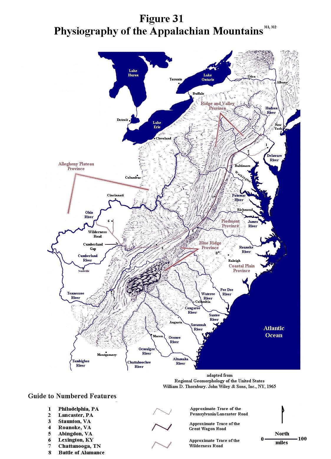
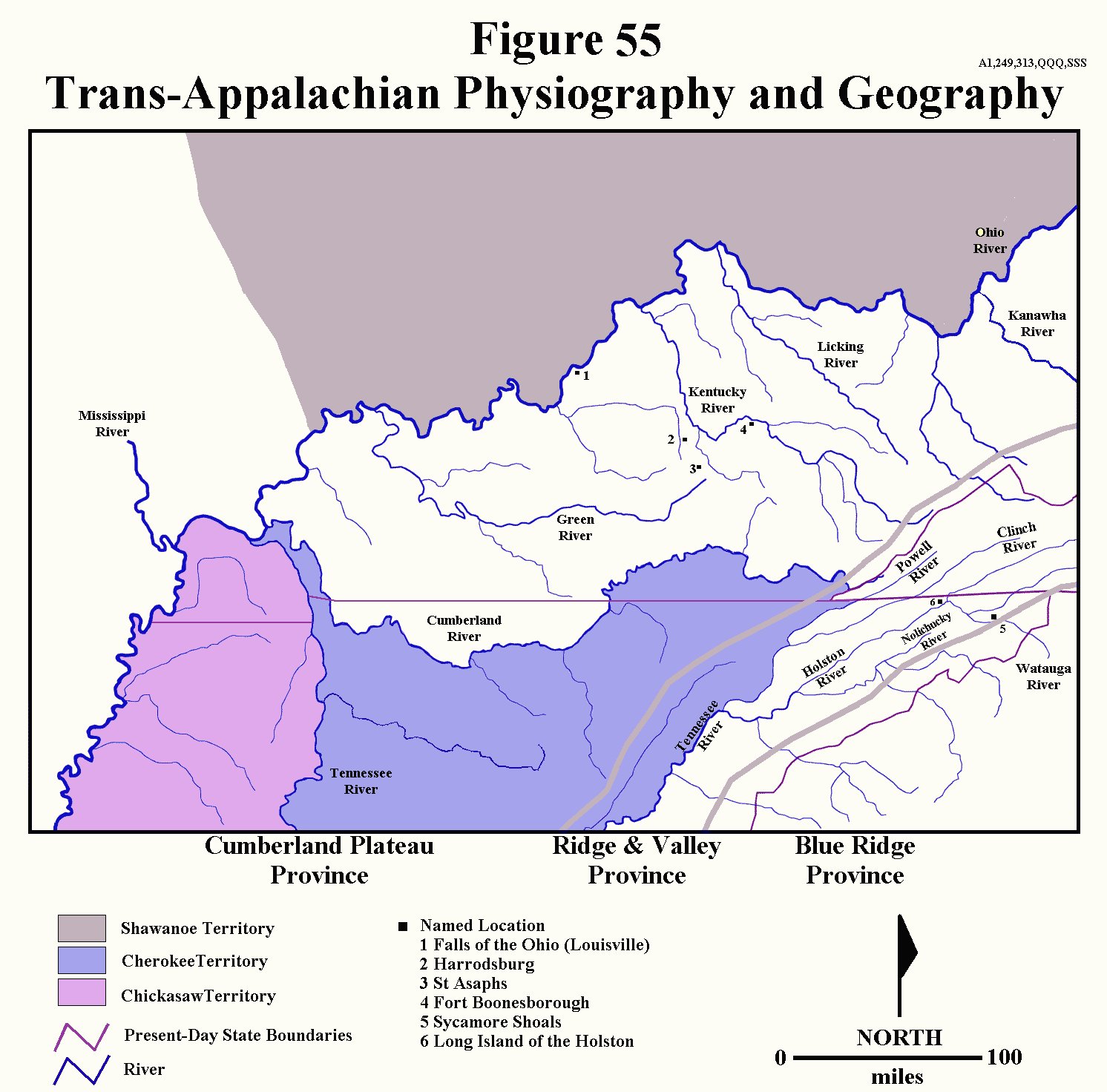
Settlements quickly began popping up in the Holston, Clinch, Watauga, Powell and Nolichucky River valleys of the Ridge and Valley Province (Figure 55). Just two years later in 1772, the rush of settlement had brought enough people into the area to justify yet another political division, resulting in the formation of Fincastle County, Virginia (Figure 21).157,160,161,191,375


   While southwestern Virginia, modern-day eastern Tennessee and Virginia's West Augusta District (part of present-day southwestern Pennsylvania and West Virginia) were filling up with Anglo-Americans, Kentucky remained, at least for a few years, virtually empty of Anglos, mostly due to resistance by the Shawanoes, and, to a lesser extent, the Cherokees. Despite the fact that the Shawanoes had, technically, ceded their interest in lands south of the Ohio, not all tribal groups accepted this territorial loss, and roving bands of warrior-hunters actively opposed all Anglo incursions into the area from southwestern Virginia northward to the West Augusta area. Throughout the early 1770s, atrocities and retaliatory raids occurred 
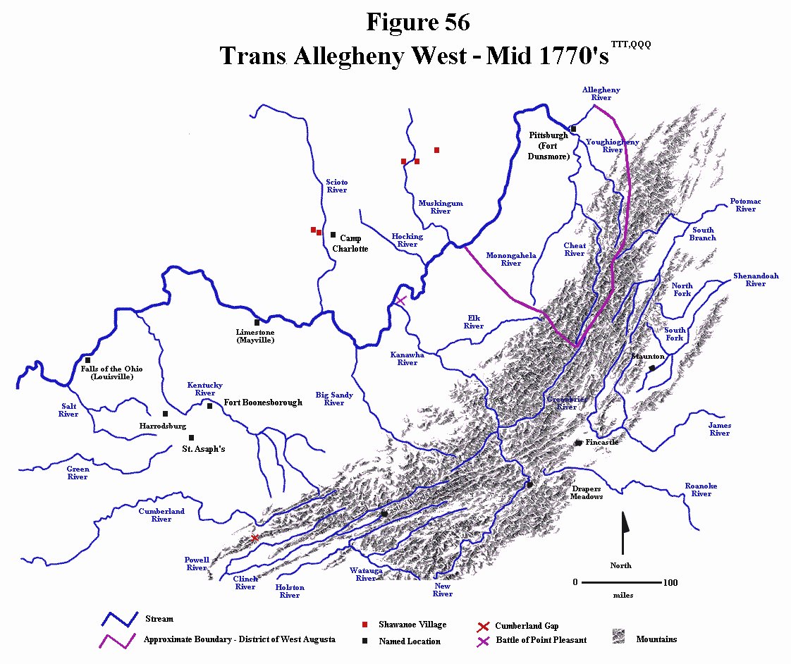
on both sides, but in 1774 events spun completely out of control. A massacre by the Anglos resulted in a Shawanoe retaliatory invasion of the Monongahela settlements in West Augusta, which then escalated and provoked a military response, all of which has become known as Dunmore's War. John Murray, also known as Lord Dunmore, the royal governor of Virginia, who had been recently been sending crews to Kentucky to survey land for Virginia war veterans, engineered a military expedition whose mission was not only to handle the Shawanoe problem, but also to support a land speculation scheme. A boundary dispute had been steaming for some time between the colonies of Pennsylvania and Virginia over the West Augusta District, and, although the effort was ultimately unsuccessful, at the time, Lord Dunmore hoped that Virginia troops in the area would tip the balance in favor of Virginia. He sent two bodies of Virginia militia against the Shawano in a giant pincers movement. The northern group, composed of militia from Frederick, Dunmore, Hampshire and Berkeley Counties (all of which were Virginia counties in the mountains along the Potomac River), made a show of Virginia power as they traveled up through the Monongahela valley to Pittsburgh, then down the Ohio River. The southern division, recruited from Augusta, Botetourt and Fincastle Counties, traveled down the Kanawha River to the Ohio River. Before the two armies could merge, the southern group was attacked by a Shawanoe coalition led by Cornstalk. The antagonists encountered each other at the mouth of the Kanawha River on the south bank of the Ohio, and after a day of fighting, known as the Battle of Point Pleasant, the Shawanoes withdrew across the river to protect their villages. The Virginia militia pursued and entered into negotiations at Camp Charlotte. Meanwhile, the northern militia group, which had not been engaged during the battle, destroyed a number of Shawanoe villages (along with the accumulated food supplies), and the combination of defeats drove the Shawanoe to the bargaining table. In the ensuing negotiations, the Shawanoe, Delaware and Mingo again ceded all claims to lands south of the Ohio, so for the next three years, at least, Anglo settlement of Kentucky was relatively free from any Native American opposition (Fig 56).157,160,161,191,375


   The first permanent Anglo American settlement in Kentucky was Fort Harrod, at the present site of Harrodsburg, founded in 1774 by a land surveyor. Several other settlements, such as St. Asaphs and Fort Boonesborough, soon followed (see Figures 55 and 56). The primary land activity in Kentucky at this time was surveying due to a new requirement by the English crown to survey any new grant lands. Being short on cash, but well endowed with newly legitimized lands south of the Ohio River, the colony of Virginia chose to reward military veterans from the recent war with land, rather than cash, through the issuance of military warrants. Non-veterans, such as wealthy speculators, could also acquire land through the purchase of a treasury warrant. Both land transfer vehicles required a land survey for validation, so, throughout the 1770s, surveying teams crisscrossed eastern Kentucky filling orders for military and treasury warrants.160,161,163,175,182,377


   In 1774, Richard Henderson, along with several other wealthy North Carolina land speculators, formed the Transylvania Company in an effort to create another British colony, as well as to develop lands west of the mountains by encouraging settlement. It was to be modeled after the Pennsylvania and Maryland proprietary colonies, where private landowners sold land to prospective settlers, and the Transylvania investors envisioned an opportunity for great profit. Using the backwoods expertise of veteran Long Hunter Daniel Boone, the Transylvania Company entered into negotiations with the Cherokee, and, in the spring of 1775, brokered what still stands as the largest private real estate transaction ever completed in the U. S. At the Treaty of Sycamore Shoals, negotiated on the banks of the Watauga River in what is now eastern Tennessee, the Transylvania Company acquired around 20 million acres of land between the Cumberland, Ohio and Kentucky Rivers in present day Kentucky and Tennessee for 2,000£ in cash and 8,000£ in trade goods. An additional 2,000£ was paid for rights to an access road from Sycamore Shoals through the Cumberland Gap. The total acquisition package amounted to only about $50,000 in today's economy. While not all tribal factions agreed with the sale, much of the Cherokee leadership was actually eager to complete the deal. The Cherokee tribes were in a weakened state after a recent war with the Shawanoes, so, by diverting Anglo settlement to the north, the treaty provided a buffer between them and the Shawanoes. Furthermore, they were also anxious to get their share of wealth from the recent tendency of the Anglos to purchase land from the natives with cash and trade goods. As soon as the sale was complete, Daniel Boone was sent to blaze what would soon become known as the Wilderness Trail through the Cumberland Gap and establish Fort Boonesborough - the field headquarters of the Transylvania Company. Opposition to the land sale surfaced immediately. In the first place, the British crown never recognized the treaty, and was somewhat uncomfortable with the entire notion of the private sale of lands technically owned by the British government.. More importantly, though, was resistance by the colonies of Virginia and North Carolina, whose sea to sea charters included all of the Transylvania Purchase. Virginia responded by organizing their portion of the Transylvania lands as Kentucky County, Virginia in late 1776 (Figure 21), and within a year or so, the active opposition of Virginia and North Carolina to any political recognition of Transylvania resulted in the invalidation of the Transylvania claims. Opposition also arose from potential settlers, who were seeking cheap or free land with little or no restrictions. Many of these new settlers were squatters, who merely took up residence on any suitable unoccupied land without regard to any formal legality such as establishing or even determining ownership. Inevitably, disputes eventually arose when the land grant companies and the recipients of the military warrants encountered these squatters. To handle the problem, the Virginia Land Office issued preemption warrants, which allowed settlers of Kentucky County the chance to buy lands adjacent to their original settlement if they could prove that they lived in the area prior to May 1779.175,185,186,187,195,216,217,230, 234,255,433,436


   Just as the first Kentucky settlements were being established, what would soon come to be known as the Revolutionary War began in the northern American colonies. The British response to initial actions was to send troops to the Massachusetts colony to quell the rebellion. Unexpectedly fierce colonial opposition at the battle of Bunker Hill in July 1775 resulted in high British casualties, and the use of captured British artillery soon forced the British to evacuate the Boston area. A new British strategy was devised to isolate the northern colonies by conquering the middle colonies, taking full advantage of widespread Loyalist sentiment and the active assistance of Native Americans. In 1776 the British invaded New York and nearly captured the American army, which retreated to New Jersey and Pennsylvania. In late 1776, however, Washington defeated a German mercenary army at Trenton, New Jersey in a surprise attack. In 1777, the British renewed their efforts to isolate the northern colonies with a pincers movement involving British troops moving south from Montreal and north from New York. Before the two wings could unite, though, the northern British army was soundly defeated at Saratoga, New York. The southern British army in the meantime had invaded Pennsylvania, defeated the Americans at Brandywine and captured the rebel capital of Philadelphia. Despite lagging morale in the American armies, from 1778 to 1780, a pivotal transformation in the direction of the war took place after the rebel victory at Saratoga. France, Spain and the Netherlands, all-powerful European rivals of England, officially recognized the American colonies, and entered the war on their side. England was now forced to distribute its military forces all over the world to protect other colonial interests rather than concentrate them against the American rebels. Perhaps of equal importance was the military and monetary support now available to the Americans. In June of 1778, American troops defeated the British at Monmouth, New Jersey, and the British army retreated to New York City where it remained cornered until the end of the war.378


   Frustrated by limited successes and outright failures to control the rebellion in the northern and middle colonies, the final British strategy called for an invasion of the southern colonies, where Loyalist sentiment was perceived to be quite high. Initial successes in early to mid 1780 in Georgia and South Carolina encouraged the British to move operations inland. After completely unexpected critical defeats at the hands of rebel forces at King's Mountain in October 1780, at the Cowpens in January 1781, as well as a costly British "victory" at Guilford Courthouse in March 1781, the British army retreated northward through Virginia to Yorktown to await reinforcements and supplies. Combined French and American troops immediately redeployed from New York to surround the British army on land. When the French fleet prevented supplies from reaching Yorktown, as well as blocking their escape, the British army was forced to surrender on 17 October 1781, effectively ending the war.378,441,442


   Except for their critical participation in the southern phase of the war, frontier settlers were, for the most part, insulated from any direct effects of the campaigns taking place on the eastern seaboard. Because of the pivotal role played by the Native Americans, however, they were far from isolated from the conflict. While the war east of the mountains was chiefly characterized by violent interactions between standing armies, the western campaigns consisted, predominantly, of guerrilla warfare. When the Revolutionary War first broke out in 1775, both sides encouraged the Native Americans to remain neutral, which, for the most part, they did. As soon as the eastern campaigns began going sour for the British, though, they changed their strategy to take full advantage of the generally pro-British Native American sentiments. With the settlers encroaching upon their lands, an accelerated British trade in high-valued arms, ammunition and household goods, not to mention a bounty placed on American scalps, it is not too surprising that Native American sentiment generally favored the British. As a result, by the summer of 1776, the Shawanoes began raiding Anglo American settlements south of the Ohio River. Dissident Cherokee began a similar campaign against settlers in present-day eastern Tennessee and southwestern Virginia, and, in 1777, the Iroquois joined in with a series of guerrilla raids in western New York and Pennsylvania. Thus, a general Native American uprising developed all along the frontier, which was very similar to the kind of warfare that had characterized the area during the preceding conflicts. The cycle of terror, murder, atrocities and revenge killings once again spun completely out of control all along the mountain borderlands from western Pennsylvania to present day eastern Tennessee. Forts were attacked, towns, villages, homes and crops were burned, isolated families were slaughtered, hostages and captives were taken, prisoners were tortured and killed, peace envoys were murdered and retaliatory raids ensured that the cycle of violence and terror continued.411,412


   The Iroquois raids soon led to a massive American counteroffensive, manifesting itself in the application of a scorched earth policy to Iroquois villages and crops, By the end of the war, Iroquois regional supremacy entered a period of decline from which it never recovered. Shawanoe attacks had nearly depopulated Kentucky by the summer of 1777, forcing those that remained to live in or near fortified towns, blockhouses or forts. George Rogers Clark petitioned the Virginia Assembly for funding to support a militia campaign to counter these British-led Shawanoe attacks by severing the British line of supply from New Orleans. Beginning in June of 1778, Clark led a group of about 200 Kentucky militiamen that easily overcame the thinly defended Mississippi River outposts at Kaskaskia, Prairie du Rocher and Cahokia, and, about a month later, he took the British outpost at Vincennes in present-day southern Indiana (Figure 53). The British commander in Detroit countered this move by retaking Vincennes in early October, but, in a daring winter raid, Clark reconquered the fort in February 1779. The next few years were characterized by bloody British-led Indian raids into Kentucky and western Pennsylvania followed by punitive counter raids by settlers into Indian territory that typically resulted in the burning of villages and crops. The violence and terror persisted for years, and, although the Revolutionary War ended in 1783, the war between the Anglo-Americans and the Ohio tribes persisted until 1795 when the British finally abandoned their efforts at acquiring territories north of the Ohio River and south of the Great Lakes.60,411,412,437,439,440,456


   At the time that Kentucky County, Virginia was formed in 1776, virtually all of the approximately 300 people comprising the Anglo population resided either in small, isolated, fortified family outposts or in the five tiny villages that composed the "urban" centers of the state at the time (Table X). Despite the continuation of the war and continuing Indian attacks, new settlers continued to pour into Kentucky through the rest of the 70's, traveling either down the Ohio River on flatboats or on foot and horseback along the recently established Wilderness Trail. Many of them were escaping the fighting in the east. By 1780, with the population sitting somewhere near 30,000, the Virginia legislature split Kentucky County into three new counties: Fayette, Jefferson and Lincoln (Figure 21 and Table X). As noted above, the end of the Revolutionary War did not immediately bring about a cessation of the terror and violence with the natives, but the center of Anglo-Native conflict shifted away from eastern Kentucky, and active opposition by Native-Americans to Anglo American expansion into the Kentucky had virtually ended by the late 1780s and early 1790s. In the absence of this final obstacle, Kentucky experienced a massive postwar influx of settlers, predominantly from Virginia. By 1790 the population had doubled to just over 60,000, and by 1800 it had more than doubled again to nearly 180,000 (Table X). In 1792, with the permission of Virginia, Kentucky was granted statehood.443,444,445,446,450,451,452,453,454,455


Table X

Trans-Appalachian Anglo-American Population Growth 467,468


Year

Kentucky

Tennessee

1776

300

7,000

1780

30,000

10,000

1790

60,000

36,000

1800

180,000

105,000


   In the area comprising the present-day state of Tennessee, Native American opposition had a somewhat different flavor, mostly, because, unlike the situation in Kentucky, both the Cherokee and Chickasaw had numerous villages in Tennessee. While most of the Cherokee abided by the terms of the Sycamore Shoals Treaty of 1775, the Chickamauga, a sizable dissident band of Cherokee, bitterly resented the sale, as well as the trend of relinquishing territory to the Anglo-Americans. The war between England and the colonies, thus, presented a unique opportunity for them to reverse the outcome of this and other treaties, so, spurred on by the British, the Chickamauga embarked upon a campaign of bloody raids on frontier settlements. Virginia and North Carolina militia, not differentiating between Chickamauga and friendly Cherokee, responded by burning a large number of villages and crops and killing any Cherokees they encountered. In 1777 the Cherokee sued for peace, and, through a treaty negotiated at the Long Island of the Holston River, they ceded territory and agreed to remain neutral during the war between the British and the colonists (Figure 55). The Chickamauga, however, continued raiding frontier settlements throughout the region, which triggered another massive Anglo-American response against their villages on the lower Tennessee River. It ultimately led to a second treaty at the Long Island of the Holston in 1781 that reaffirmed the earlier treaty. The Chickamauga were eventually forced from the area, and joined the Shawanoe, north of the Ohio River, although they soon returned to central Tennessee and northern Alabama. From this base they continued to attack Anglo American settlements throughout the rest of the 1780s and early 1790s, this time encouraged by the Spanish. After losing Spanish support in the mid 1790s, they moved west of the Mississippi, which, essentially, ended their opposition to the Anglo-American trans-Appalachian expansion.60,411,412,439,447,448,449


   By the end of the Revolutionary War, the only two areas under Anglo-American control in western North Carolina (i.e. present-day Tennessee) were an arc-shaped area comprising the Cumberland River drainage basin, and the northeastern corner of what would eventually become Tennessee - an area also known as upper east Tennessee (Figure 55). While there were Anglo settlements in both areas, the bulk of the trans-Appalachian North Carolina settlers had been living in the latter area since the late 1760's, and most of them were either Virginians or refugees of the North Carolina Regulator Movement. State and colony rivalries at this time were still quite common. Most Virginia natives felt no compunction to obey North Carolina authorities, and the Regulator refugees were down-right hostile to North Carolina. The Regulator Movement was, essentially, a conflict between the Carolina landed gentry of the tidewater region and poor subsistence farmers living in the eastern foothills of the Appalachian Mountains. Tax policies created by the wealthy and powerful easterners required payment-in-kind if a landowner had no cash to pay his taxes, and, in a cash-strapped barter-based society, such as was prevalent in the Carolina piedmont, the resulting confiscation of livestock and farm implements incensed the backwoodsmen and threatened their very existence. Conflict erupted as armed vigilante groups, known as the Regulators, openly defied North Carolina government officials and authority. The climax was the Battle of Alamance in 1771 in which the Regulator "army" was soundly defeated (Figure 31). Many of the Regulator refugees fled across the mountains to populate the upper east Tennessee settlements of the Ridge and Valley Province. Consequently, the bulk of the residents of the upper east Tennessee area were not particularly friendly toward North Carolina.377,461,462,465


   Finding the area difficult to manage and defend both during and after the Revolutionary War, the state of North Carolina ceded the western territories of their sea to sea charter to the Continental Congress in order to pay off debts generated during the war. A great percentage of these debts had been generated in the defense of these upper east Tennessee settlements against the British-allied natives. Objections arose immediately, mostly from the residents of this area, who feared that they would have no protection from the still-frequent Indian attacks. Their choices for governmental protection seemed to be a weak and ineffective central government or a despised state government. The cession offer was withdrawn by North Carolina in 1784, whereupon the settlers in the area formed a new state they called Franklin (in honor of Benjamin Franklin). Until North Carolina actually ratified the U.S. Constitution, the rather odd situation that prevailed in this part of the country was that of two "states" with overlapping territorial claims, both vying for statehood. The original intention of the Franklin state appears to have been the formation of a separate nation, independent of the United States, although they eventually appealed for recognition by the Continental Congress. National acceptance was not immediately forthcoming. Although North Carolina, at first, encouraged this development, acceptance soon turned to active opposition. Despite the fact that the state of Franklin had already elected their own governor and assembly, North Carolina organized the area as the Washington district with it's own government officials, so for a time, there were two rival governmental bodies in northeastern Tennessee. The ultimate dissolution of the state of Franklin came about as a result of severe internal divisions, active opposition by North Carolina, and a resurgence of Indian hostilities in which cooperation with North Carolina authorities became necessary for survival. The newly formed U.S. federal government refused to recognize Franklin's appeal for statehood, which, no doubt, was influenced by the action of at least some Franklin members to create a separate country allied with Spain. North Carolina eventually reestablished jurisdiction over its western territories during the late 1780s. In 1796, with the full permission of North Carolina, Tennessee was granted statehood.461,462,463,464,465,466


   After a nearly two centuries of bloody struggle that began with the establishment of the English Atlantic seaboard colonies in the 1600's, Anglo-Americans were finally successful in overcoming the political, military, cultural and geographic obstacles confining them east of the Appalachians. The history of this long struggle was characterized by successive cycles of violence and terror alternating with relatively quiescent periods of peace and prosperity, and once the European and Native American obstacles had been eliminated, an unbridled westward expansion of humanity ensued. As this long struggle developed, though, the identity of the settlers evolved from distinctly European to uniquely American. Over the next century, the human tide of mostly English speaking American settlers proceeded to occupy nearly every available niche between the Appalachians and the Pacific Ocean. 


Entry Page

Genealogy Report

Figures, Tables and Bibliography
Search this site


**WARNING**

These electronic pages may NOT be reproduced in any format for profit or presentation by any other organization or persons.  Persons or organizations desiring to use this material must obtain the written consent of the contributors, or the legal representative of the submitters

Last Revised:02/26/2009