This site has a sound background. Please adjust the sound or shut off the music to suit your tastes. Thank you. :)
|
Sooner or later, most people researching their genealogy come across Deeds of Ownership, Maps and other legal paperwork for our ancestors. In many cases, a few questions arise over some of the wording or even what maps to look for next to further help in showing where these properties lie. This page is not a complete explanation of all that a person will need to know in understanding these, sometimes confusing, documents.. but it will contain enough data to help you in understanding what you are seeing a little better. In addition to the more technical end of things, this page will also show information concerning Ireland Land Ownership. |
Ownership of Land in Ireland: Irish Land Question was name given in the 19th cent. to the problem of land ownership and agrarian distress in Ireland under British rule. The long-term result of conquest, confiscation, and colonization was the creation of a class of English and Scottish landlords and of an impoverished Irish peasantry with attenuated tenant rights. In the 18th cent., under the Penal Laws, Roman Catholics�the vast majority of the Irish population�were prevented from acquiring land. Tenants� improvements were discouraged because they led to higher rents. Eviction on short notice was also a problem. The securing (1829) of Catholic Emancipation brought into the British Parliament Irish Catholics who sympathized with the miserable tenantry, and the terrible Irish famine of the 1840s focused attention on the land question. In 1849, Parliament passed the Encumbered Estates Act, which provided for the sale of mortgaged estates. However, its liberal purpose was defeated by speculative purchasers who made the rents even more extortionate from the tenants� point of view. The Irish Tenant Right League, established in 1850, demanded the �three F�s��fair rent, fixity of tenure, and freedom of sale. The violence of the Fenian movement, the extension of the franchise by the Reform Act of 1867, the movement for Home Rule, and assistance from the Liberal party, headed by William Gladstone, furthered the cause of the tenant. Gladstone�s Land Act of 1870 protected the tenant from arbitrary eviction and provided some compensation for improvements. A major agricultural depression beginning in the 1870s brought a new crisis. The National Land League, founded under the leadership of Michael Davitt and Charles Stewart Parnell, conducted a campaign of boycott and violence that influenced the passage of the Land Act of 1881, called the �Magna Carta� of the Irish farmer. It recognized the three F�s and provided a land commission to fix a �fair rent.� Thereafter land purchase by the tenant became the predominant issue. The Ashbourne Act of 1885 and supplementary acts of 1887 and 1891 provided a loan fund of many millions of pounds for tenants who wished to purchase their lands. Difficulties remained because the Anglo-Irish magistracy, which favored the landlords, did not satisfactorily implement the new laws. The Irish National League, an outgrowth of the suppressed National Land League, advocated withholding of rents from extortionate landlords. Its activities, too, were suppressed. The Irish Agricultural Organization Society, fostered (1894) by Sir Horace Plunkett, began to encourage agricultural cooperation and improved farming methods; this led to the establishment (1899) of the Irish Dept. of Agriculture. The agitation of the United Irish League, under William O�Brien, demanding compulsory sales by landlords, led to the Wyndham Act of 1903 and the Amended Land Purchase Act of 1909. The Wyndham Act, which provided loans to tenants at reduced interest for the purchase of land and gave bonuses to landlords who sold, proved, in effect, a solution to the Irish Land Question. In 1907 the Evicted Tenants Act provided for the compulsory sale of land needed for evicted tenants. By 1921 two thirds of the land in Ireland had become the property of Irish tenants, and a compulsory law transferred the remaining portions soon after the establishment (1922) of the Irish Free State. |
|
These terms are sometimes found on maps, but mostly are found in deeds and property description. |
|
Aliquot | The description of fractional section ownership used in the U.S. public land states. A parcel is generally identified by its section, township, and range. The aliquot specifies its precise location within the section, for example, the northwest quarter of the southeast quarter. |
Benchmark | A survey mark made on a monument having a known location and elevation, serving as a reference point for surveying. |
Call | Any feature, landmark, or measurement called out in a survey. For example, "two white oaks next to the creek" is a call. |
Conditional line | An agreed line between neighbors that has not been surveyed, or which has been surveyed but not granted. |
Corner | The beginning or end point of any survey line. The term corner does not imply the property was in any way square. |
Declination | The difference between magnetic north and geographic (true) north. Surveyors used a compass to determine the direction of survey lines. Compasses point to magnetic north, rather than true north. This declination error is measured in degrees, and can range from a few degrees to ten degrees or more. Surveyors may have been instructed to correct their surveys by a particular declination value. The value of declination at any point on the earth is constantly changing because the location of magnetic north is drifting. |
Gore | A thin triangular piece of land, the boundaries of which are defined by surveys of adjacent properties. Loosely, an overlap or gap between properties. See also strip. |
Landmark | A survey mark made on a 'permanent' feature of the land such as a tree, pile of stones, etc. |
Line Tree | Any tree that is on a property line, specifically one that is also a corner to another property. |
Merestone | A stone that marks a boundary. See monument. |
Monument | A permanently placed survey marker such as a stone shaft sunk into the ground. |
Out | An 'out' was ten chains. When counting out long lines, the chain carriers would put a stake at the end of a chain, move the chain and put a stake at the end, and so on until they ran "out" of ten stakes. |
Point of Beginning | The starting point of the survey. Also known as the `First Station'. |
Plat | A drawing of a parcel of land. |
Range | In the U.S. public land surveying system, a north-south column of townships, identified as being east or west of a reference longitudinal meridian, for example, Range 3 West. See township. |
Searles Spiral | A surveying technique used by railroad surveyors in the the late 1800s and early 1900s whereby they approximate a spiral by use of multiple curved segments. |
Section | In the U.S. public land surveying system, an area about one mile square. The sections are organized in rows and colums and are labelled by numbers, for example, Section 36 of Township 13. See range and Township. See Aliquot. |
Strip | A rectangular piece of land adjoining a parcel, created when a resurvey turns up a tiny bit larger than the original survey. The difference is accounted for by temperature or other effects on measuring chains. See also gore. |
Township | In the U.S. public land surveying system, an area six miles square, containing 36 sections. The townships are organized in rows and are identified with respect to a reference latitudinal baseline, for example, Township 13 North. See range. |
Witness Tree | Generally used in the U.S. public land states, this refers to the trees close to a section corner. The surveyor blazed them and noted their position relative to the corner in his notebook. Witness trees are used as evidence for the corner location. |
This section is what I call aa "fun" section, for rarely will you see these most of these terms written on Official Documents.
|
The maps shown below are primarily intended to provide an example of what the map may look like. |
||
Click on map for a larger view | Typical Road Map | The Road Map is very useful for locating towns and cities. Since many modern roads follow old roads and trails, the Road Map can not only direct you to the places you want to go, but it can give an idea of the ways your ancestors may have travelled. |
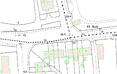
Click on the image for a larger View | Place Maps. | Details shown on these types of maps may include buildings, lots, streets, alley ways, and street furniture (such as telephone kiosks, lamp standards, fire hydrants). These maps may also be known by other names, depending on where you live. |
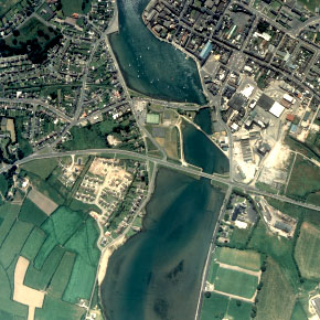
Click on map for a larger view | Aerial Photos | Aerial Photos are considered Maps, despite the fact that many find it hard to think of a photo as a map. :) These maps are at an approximate scale and measurements can be made on them with an accuracy good for that Close Enough job - and in addition you can actually see landmarks to help you outline a particular area. |
Click on the map for a larger view | Typical Ordnance Survey Map | This is a copy of original Ordnance Survey Map 76, containing the numbers and boundaries of holdings as cited in Griffith's Primary Valuation. You also may utilize similar style of maps, known as Survey Maps, which shows more specific areas or individual properites. |
No Map Available | Parcel Map | �Parcel map� means a map showing a division of land of four (4) or less parcels (with specific exceptions) as required by this ordinance, prepared in accordance with the provisions of this title and the Subdivision Map Act. |
No Map Available | Plot Plan | �Plot plan� means a plan graphically describing proposed and existing buildings, structures, lot lines, and other required information submitted in conjunction with an application for discretionary or ministerial review and approval. |
No Map Available | Tentative Map | �Tentative map� means a map made for the purpose of showing the design and improvements of a proposed subdivision and the existing conditions in and around it. You won't find many Tenative Maps in Genealogy. |
No Map Available | Final Map | �Final map� means a map showing a subdivision for which a tentative and final map are required by the California Subdivision Map Act or this title, prepared in accordance with the provisions of this title and the California Subdivision Map Act, and designed to be recorded in the office of the County Recorder. You may not find many Final Maps in Genealogy either. |