Maps of Mercer County, Illinois
Advertisement


Map Links
---------------------------


Mercer Home Page
Return to Maps West Page for Mercer
Return to Maps West Page for Woodward
Return to Resources Page


Mercer County Townships
Courtesy Kevin Martin (Note: It is copyrighted so is only for personal use)


Section Divisions Illustrations
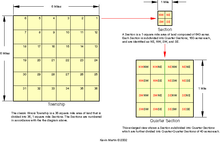
courtesy Kevin Martin


If you need further instruction there is a fine Tutorial Web Site Range Maps for Dummies on the survey system used today in the State of Illinois. The site also includes a link to a large map of Illinois with all the ranges and townships labeled for all the Counties. To find Illinois Land Records: Bureau of Land Management

Mercer County Cemetery Location Maps - on a USGS map base showing roads, etc. - courtesy Kevin Martin


Abraham Lincoln's Survey of the town of New Boston


1875 New Boston Township Plat (T14N R5W)


1875 Eliza Township Plat (T15N R5W)


1875 Eliza Township Plat (T15N R6W)


One of the finest historical Web Sites on the Internet is the Library of Congress - American Memories Web Site. One of their collections is Railroad Maps. It covers many regions and many time periods. The 1854 County Map below was cut out of one of its Illinois Railroad Maps. It takes time and patience and lots of memory to download one of their maps so we may not do many but it is a fun site to visit.

Railroads in Mercer and surrounding Counties - 1854


A map of Mercer County was published and sold in 1856 but we have been unable to locate a copy. According to the Illinois Regional Archives Depository the earliest map of Mercer County in existence is from 1864 and is currently located at the Mercer-Carnegie Library in Aledo. Maps at the Essley-Noble Museum include: 1864 by Thompson; 1875 by Brink; 1892 Plat Book; 1904 Hixson; 1923 Plat Book & Farm Ownership.


The Mercer County Historical Society has an old undated map on their web site that shows locations of the old towns as well as township lines.
(New web site pending 12/2009)


Illinois County Boundaries 1790 - 2000 - maps showing how county boundaries changed over time


The Illinois State Archives is digitizing Federal Township Plats of Illinois (1801-1899). They take an extremely long time to load but are very worthwhile when you do get them


Military Tract: A military tract was set up in Illinois in 1818 for Veterans of the War of 1812 (For description see Part I History Page) . New Boston and Eliza Townships were part of this tract being in the extreme northwest corner of Mercer County at Townships 14 & 15 North and Ranges 5 & 6 west just along the Mississippi River.

Illinois Military Tract Map - original


Illinois Military Tract Map - 1850


1895 U. S. Atlas + more links


For convenience Maps of Iowa has been included on this site as many, many New Boston and Eliza Township families had land on both sides of the River and many families eventually migrated to Iowa

Iowa Connections


The U. S. Geological Survey Maps are up on the Internet. Places can be located by town, township, or feature name. U. S. Geological Survey topographical maps are also on line. On the topographical maps your spelling of a feature must be exact. If it doesn't have what you want try alternate spellings. The easiest way to use it for Mercer County is to ask for New Boston in Illinois. When that comes up there are clickable arrows on the side of the map to move north south east and west from New Boston.

U. S. Geological Survey Maps


USGS Topographical Maps
(12/2009 available through a 14 day free membership to Trails.com)


Maps and links for researching your ancestors who moved West from Mercer County. Some of the links may also be useful for how your ancestors immigrated to Mercer County in the first place.


Advertisement