Historical Map of Kentucky and Her Counties, 1800-1806
| Home | Index of Maps | 1780-84 | 1785-86 | 1787-92 | 1794-96 | 1800-1806 | 1823-37 |
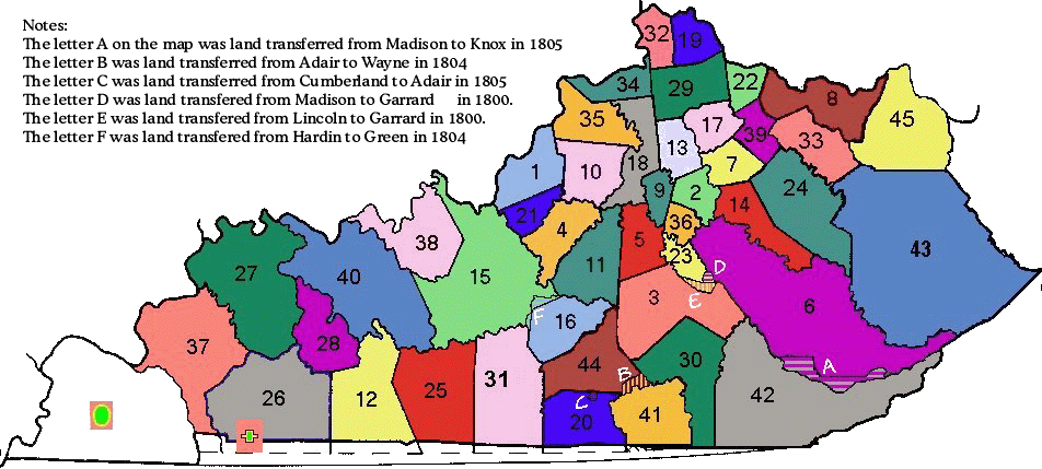
Kentucky had 45 counties by 1806; and a total of 25 of them were named for Virginians, 17 for natives of other states and nations, and 3 for geographical areas and rivers.
20
Cumberland
16 1796 21
Bullitt 1/4 1796 22
Bracken
19/8 1796
23
Garrard
6/3/5 1796
24
Montgomery
14 1796
25
Warren
12 26
Christian
12 1797
27
Henderson
26 1798
28
Muhlenberg
26/12 1798
Revolutionary War General, John Pete Gabriel Muhlenberg
29
Pendleton
22/19 1798
30
Pulaski
16/3 31
Barren
16/25 1798
32
Boone
19 1798
33
Fleming
8 1798
34
Gallatin
18/10 1798
35
Henry
10 36
Jessamine
2 1798
37
Livingston
26 1798
38
Breckinridge
15 1799
Att. Gen. John Breckinridge 39
Nicholas
7/8 1799
Colonel George Nicholas 40
Ohio
15 41
Wayne
30/20 1800
General Anthony Wayne 42
Knox
3 1800
General Henry Knox 43
Floyd
33/8/24 1800
Colonel John Floyd 44
Adair 16 1802
General-Governor John Adair 45
Greenup
8 Christopher Greenup, who served as a representative to Congress and then was elected Governor of Kentucky in 1804
Copyright 2000 by Travler Designs�
...a web page creation and consulting firm.
All rights reserved. ~ Revised September 6, 2000