Family Farms

RobbHaas Family Pages
Foulke - Haas - Robbins - Worthen  Families

index sitemap advanced
search engine by freefind

Page Update Log
Page Updates Notification

Family Farms
Hamilton County, Indiana

Home Places Index Hamilton County, Indiana   Map #1 Map #2 Map #3 Map #4   Sources
Foulke Family Farms Robbins Family Farms Tomlinson Family Farms Underwood Family Farms

 
Robbins Family Farms
My branch of the Robbins family (Isaac Robbins, ID0069 and Oscar Robbins, ID0014) never owned property in Hamilton County - They always rented land.

Oscar did own land in Henry, Randolph and Delaware Counties in Indiana.

Top of Page

Map #1
Tomlinson, Hiatt Family Farms (1880)
Washington Township, Northeast Corner
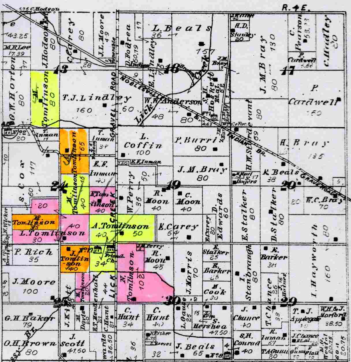


Source:  S1 between pages 134 and 135
Archive.org
Online - Color Map
Tomlinson: 
A. (Allen)Tomlinson, ID0764 - 124 acres
A. (Asenath) Tomlinson, ID0933 - 65 acres  - Sec 24, Top, north central -
E. (Esther) Tomlinson, ID0762 - 20 acres
J. (Jane)Tomlinson, ID0763 - 40 acres
L. (Levi)Tomlinson, ID0934 - 90 acres
M. (Milton) Tomlinson, ID0184 - 90 acres  
N. (Noah) Tomlinson, ID0765 - 142 acres


Note: These are the living children of Robert Tomlinson at the time of his death in 1875
Hiatt: 
E. (Enos) Hiatt, ID2129 - Section 26 - 78.75 acres  - 
J. (????) Hiatt, Section 14 - 78 acres  -
M. (???) Hiatt - Section 22 - 39 acres (Not on this map)  - 
S. (Solomon) Hiatt, ID0067 -  Section 14 -  80 acres  - 
 
Baker
G. H. (George Hayburn) Baker, ID1007 - 79 acres - Section 25
Chester Friends Meeting house, School (County School #17) and Cemetery - Lick Creek Gravel Road (Present day U.S. 31) on the property of Allen Tomlinson in the center of Sections 24, 19, 25 and 30
Sources
 

Top of  Page

Map #2
Underwood Family Farms (1880)
Adams Township, Southwest Corner


Source:  S1 between pages 102 and 103
Archive.org
Online Color Map

L. (Lewis) Underwood, ID0201    - 48 acres 
I. (Isaac) Underwood, ID3762?   - 160 acres
J. (John?) Underwood, ID3763? - 198.5 acres

Lewis Underwood Family Photos (1880)  - Link,
Lewis Underwood Farm (1880)  - Link,

Top of  Page

Map #3
Adams Township, Southeast Corner (1880)

Source:  S1 between pages 102 and 103
Archive.org
Online Color Map


J. B. (John Baker) Foulke ID0091 - 40 acres - Section 4

M. (Marvin?) Foulke ID0107 - 80 acres - Section 4
U. (Uri) Hodson ID0143 - 120 acres - Section 4
J. (John T.) Hodson  ID1624 - 160 acres - Section 4
Several Bakers listed on this map
 
Sources
Foulke Family Points of Interest, Hamilton County, Indiana  (Google Custom Map)

Top of  Page

Map #4
Foulke Family Farms (1880)
Jackson Township, Southwest  Corner

Source:  S1 between pages 120 and 121
Archive.org
Online Color Map

The original Jesse M. Foulke Farm consisting of 284 acres in 1866 is now divided between the Estate and the Children below in 1880
J. [Jesse M.] Foulke, ID0088 - 108.64 acres - Anthony Rd., south of 236th St. in Jackson Township
G. [George] Foulke, ID0076 -  73.32 acres - Southeast corner of 236th St. and Anthony Rd. in Jackson Township
J. B. [John Baker] Foulke, ID0091
   - Property:  73.32 acres - Anthony Rd., south of 236th St., east side of road in Jackson Township
   - Home Farm:  40 acres - Adams Township (Map 3)
S. [Sarah Foulke] McShane, ID0093 - (Daughter of Jesse M. Foulke) -  "S. McShane" on map - 36.96 acres - Anthony Rd., south of 236th St. in Jackson Township
 
Sources
Foulke Family Points of Interest, Hamilton County, Indiana  (Google Custom Map)
 

Top of  Page

Sources
 

Source Citation

Image
(Click for larger View)
(To Magnify larger image - use CTRL + )

S1 T.B. Helm, History of Hamilton County, Indiana, Reprint (Chicago: Kingman Brothers, 1880. Reprint: Evansville, Indiana: Unigraphic 1976, Bk1604).

Adams Township Archive.org

Jackson Township Archive.org

Washington Township Archive.org

Online, Color Maps
Archive.org
S2    
S3    
S4    
S5    


Top of  Page  

Email Me for More Information  -  Page updated:  21 April, 2016  -  ©Copyright - RobbHaas

Be notified of
page updates

it's private

powered by
ChangeDetection