The Land Use of the Bridgebrook Estate, Parson's Heath
My house is part of the Bridgebrook Estate in Parson's Heath, Colchester. Indeed, it is next to the evocatively-named Bridgebrook Green. The very name brings an image of rural idyll to the mind's eye: the brook babbling quietly in the background, the rustic bridge leading over the brook onto the old village green, where for centuries the inhabitants of Parson's Heath have danced round the maypole, or sat quaffing mead and puffing on their clay pipes.
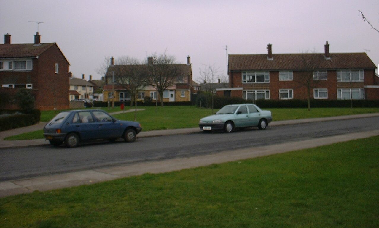
The truth is nothing like this. Actually, "Bridgebrook Green" is a triangle of grass between Hazelton Road and my house, with sides of 30, 30 and 45 metres. A larger-than-usual grass verge, but a grass verge nonetheless. This essay traces the land use of the Bridgebrook Estate, and in passing attempts to find what might have justified the name.
I refer to a number of maps and plans:-
- Present day, Streetmap.co.uk
- 1777, Chapman & Andre's map
- 1797, Map of the Estates of Lady Lucas
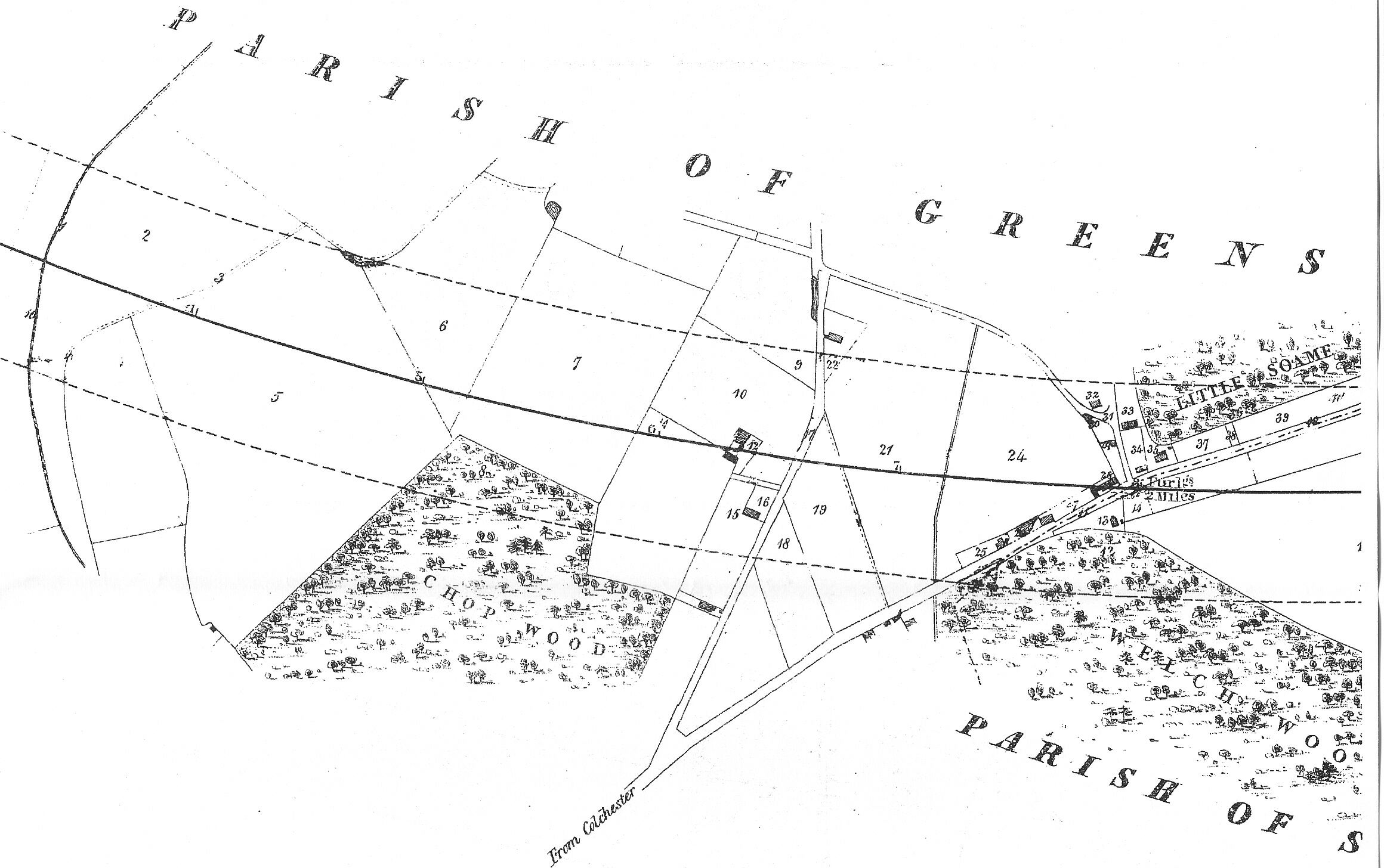
- 1797, Map of Parson's Heath Farm
- 1838, Greenstead Tithe Map
- 1844, Plan of the Colchester and Bury Railway
- 1845, Plan of the Eastern Counties Railway
- 1875, Ordnance Survey 6" map
- 1875, Ordnance Survey 25" map
- 1924, Ordnance Survey 6" map
- circa 1960, Barnett's street plan
(On maps,  marks the approximate location of the house.
Clicking on the map will bring up a larger version)
marks the approximate location of the house.
Clicking on the map will bring up a larger version)
Present Day

The 1:25000 map above, and 1:10000 aerial photograph below, give a good idea of Bridgebrook today: a mostly built-up area, though there are a few open spaces, with a railway line passing through.

1777

According to the Victoria County History,
As late as 1774 Colchester was surrounded by heaths which provided rough grazing. They included ... Parson's Heath.
This is only partially confirmed by the Chapman & Andre map of 1777 (above). This does not show Parson's Heath by name, but only the eastern part is shown as heathland, to the south of Soame Wood, and even part of that appears to have been cleared. The western part is shown as farmland to the east of Dilbridge Farm.
1797

By 1797, Parson's Heath had become part of the estates of Baroness Lucas (above). Parson's Heath Farm (below) was then occupied by John Angier.

As Parson's Heath was at least partially farmed by 1777, it seems likely that it was enclosed by non-parliamentary actions predating the Enclosure Acts. This is confirmed by Tate, 1978, which lists no relevant Enclosure Act.
1838

The Tithe Map of Greenstead (above), surveyed in 1838, shows Parson's Heath is now almost completely converted to farmland. The Tithe Award shows the various fields to be
| Plot No | Name & Description | Clt. | Quantity | Landowner | Occupier |
|---|---|---|---|---|---|
| a.r.p. | |||||
| 245 | Glaze Lights | W | 14.2.27 | De Grey, Earl | Blomfield, William |
| 246 | Glaze Lights | A | 7.0.04 | De Grey, Earl | Blomfield, William |
| 247 | Six Acres | A | 6.1.16 | De Grey, Earl | Blomfield, William |
| 248 | Upper Nine Acres | A | 8.1.21 | De Grey, Earl | Blomfield, William |
| 249 | Plum Tree Field | A | 6.3.12 | De Grey, Earl | Blomfield, William |
| 250 | Four Acres | A | 4.1.05 | De Grey, Earl | Blomfield, William |
| 251 | Hog Field | A | 6.2.39 | De Grey, Earl | Blomfield, William |
| 258 | Wood Field | A | 3.0.03 | Nash, James | Stanway, William |
1841
In the 1841 census, William Blomfield is listed as living in Parsons Heath
| Name | Age of | Rank, Profession or Occupation | Born in Essex? | |
|---|---|---|---|---|
| Male | Female | |||
| Wiliam Blomfield | 35 | y | ||
| Mary Walford | 25 | Housekeeper | y | |
| William Porter | 14 | Ag Lab | y | |
1844
There was a major change of land use in about 1846, when the Eastern Union Railway was built across Parson's Heath. In 1836, the Eastern Counties Railway had started to build a line from London to Ipswich, but had ran out of money, their line ending at Colchester. Extension of the line continued following the passing of the Enabling Act 9 Victoria xcvii on 26 June 1846. The line opened in 1847.
Section X of the Act states that a Plan and Book of Reference of the Railway, showing the Lands through which it was to pass, had been deposited with the Clerk of the Peace of the County of Essex.
In fact, two such deposits were made. The first referred to the Colchester and Bury Railways (above), and was deposited 30 November 1844. The relevant entries from the Book of Reference are:-
| Ref | Description | Owner | Occupier |
|---|---|---|---|
| 2 | Field, Footpath and Watercourse | Earl de Grey and the Eastern Counties Railway Company | William Blomfield and the Eastern Counties Railway Company |
| 4 | Field | Earl de Grey and the Eastern Counties Railway Company | William Blomfield and the Eastern Counties Railway Company |
| 5 | Field | Earl de Grey and the Eastern Counties Railway Company | William Blomfield and the Eastern Counties Railway Company |
| 6 | Field | Earl de Grey and the Eastern Counties Railway Company | William Blomfield and the Eastern Counties Railway Company |
| 7 | Field | Earl de Grey and the Eastern Counties Railway Company | William Blomfield and the Eastern Counties Railway Company |
| 8 | Wood | Earl de Grey and the Eastern Counties Railway Company | William Blomfield and the Eastern Counties Railway Company |
1845
The second deposited Plan and Book of Reference referred to Part of the Eastern Counties Railway (below), and was deposited 30 November 1845.

The relevant entries from the Book of Reference are now:-
| Ref | Description | Owner | Occupier |
|---|---|---|---|
| 4 | Footpath | Surveyors of Highways | |
| 5 | Footpath | Surveyors of Highways | |
| 6 | Footpath | Surveyors of Highways | |
| 7 | Field | Earl de Grey | William Bloomfield |
| 8 | Railway and Works | Earl de Grey and the Eastern Counties Railway Company | |
| 9 | Field | Earl de Grey | William Bloomfield |
| 10 | Field | Earl de Grey | William Bloomfield |
| 11 | Field | Earl de Grey | William Bloomfield |
| 12 | Field | Earl de Grey | William Bloomfield |
| 13 | Field | Earl de Grey | William Bloomfield |
1851
In the 1851 census, William Blomfield is listed as living in Parsons Heath
| Name | Relationship to Head of Family | Condition as to Marriage | Age of | Rank, Profession or Occupation | Where Born | |
|---|---|---|---|---|---|---|
| Male | Female | |||||
| William Blomfield | Head | U | 47 | Farmer of 100 acres employing 6 labourers | Dedham ESS | |
| Mary Walford | Housekeeper | U | 38 | Housekeeper | Maldon ESS | |
| Hannah Totman | Servant | U | 14 | House Servant | Boxted ESS | |
1861
In the 1861 census, William Blomfield, now married, is listed as living in Parsons Heath
| Name | Relationship to Head of Family | Condition as to Marriage | Age of | Rank, Profession or Occupation | Where Born | |
|---|---|---|---|---|---|---|
| Male | Female | |||||
| William Blomfield | Head | Mar | 57 | Farmer of 110 acres (employing 4 labourers and 1 boy) | Dedham ESS | |
| Mary Blomfield | Wife | Mar | 47 | Maldon ESS | ||
| William Blomfield | Son | Un | 7 | Greenstead ESS | ||
| Sarah E Merry | Servant | 18 | 18 | House Servant | Lexden ESS | |
1871
In the 1871 census, the farm is listed in St John's Lane, now being farmed by the widowed Mary Blomfield
| Name | Relationship to Head of Family | Condition as to Marriage | Age of | Rank, Profession or Occupation | Where Born | |
|---|---|---|---|---|---|---|
| Male | Female | |||||
| Mary Blomfield | Head | Wid | 57 | Farmer of 137 acres employing 5 men and 1 boy | Maldon ESS | |
| William Blomfield | Son | Unm | 17 | Farmer's son | Colchester ESS | |
| George Canham | Servant | Unm | 20 | Ag Lab | Colchester ESS | |
1875

The Ordnance Survey 6in map of 1875 (above) shows more woodland converted to arable. Having a railway cutting the farm in two would seem a major inconvenience, but there does appear to be a footpath passing underneath the railway line joining the two halves, which is confirmed from the 1:2500 Ordance Survey map (below).

The 1:2500 Ordnance Survey map also shows that the small fields of 1838 have been coalesced into larger ones more suitable for mechanised agriculture.
The boundary between St John's Road Farm and Downhill Farm, and that between St John's Road Farm and Dilbridge Farm, runs along a valley. Water draining off the valley forms what might be called a brook, but it is too insignificant to be given a name, even on the 1:2500 map.
1891
In the 1891 census, the farm is listed in St John's Road, now being farmed by William Wyncoll
| Name | Relationship to Head of Family | Condition as to Marriage | Age of | Rank, Profession or Occupation | Where Born | |
|---|---|---|---|---|---|---|
| Male | Female | |||||
| William Wyncoll | Head | S | 31 | Farmer | Colchester ESS | |
| George Wyncoll | Brother | S | 26 | Farmer | Colchester ESS | |
| Charlotte Griggs | Housekeeper | S | 54 | House Keeper Domestic | Colchester ESS | |
1901
In the 1901 census, the farm is listed as Bloomfield's Farm, still being farmed by William Wyncoll
| Name | Relationship to Head of Family | Condition as to Marriage | Age of | Rank, Profession or Occupation | Where Born | |
|---|---|---|---|---|---|---|
| Male | Female | |||||
| William W Wyncoll | Head | S | 41 | Farmer | Colchester ESS | |
| Charlotte S Griggs | Housekeeper | S; | 68 | Housekeeper | Belchamp St Paul ESS | |
1911
In the 1911 census, the farm is listed as St John's Road Farm, Ipswich Road. It is still being farmed by William Wyncoll, now married.
| Name and Surname | Relationship | Age and Sex | Particulars of Marriage | Profession or Occupation | Birthplace | Nationality | ||||||||
|---|---|---|---|---|---|---|---|---|---|---|---|---|---|---|
| Condition | Complete Years Married | Children of present marriage | Occupation | Industry | Employer, Worker, or Own Account? | At Home? | ||||||||
| Male | Female | Born | Living | Died | ||||||||||
| William Wrench Wyncoll | Head | 51 | married | Farmer | Employer | At Home | Mile End, Colchester ESS | British parentage | ||||||
| Fanny Wyncoll | Wife | 35 | married | 9 | 2 | 2 | - | Birch, Colchester ESS | British parentage | |||||
| Ernest William Wyncoll | Son | 8 | Colchester | British parentage | ||||||||||
| Hilda Frances Wyncoll | Daughter | 6 | Colchester | British parentage | ||||||||||
| Lilian Kate Wass | Servant | 25 | single | Colchester | British parentage | |||||||||
1924

The Ordnance Survey 6in map of 1924 (above) shows a remarkably similar landscape to that of 1875. The farm is now named as St John's Road Farm. The neighbouring "Downhill Farm" is now "Pondfield Farm", although the two are so close in pronunciation that one might be a mis-heard version of the other.
1939

The 1939 Survey shows that St Johns Road Farm had been taken over by William Wrench Wyncoll's son Ernest, while William, Fanny and Hilda lived in the adjacent house.
circa 1960
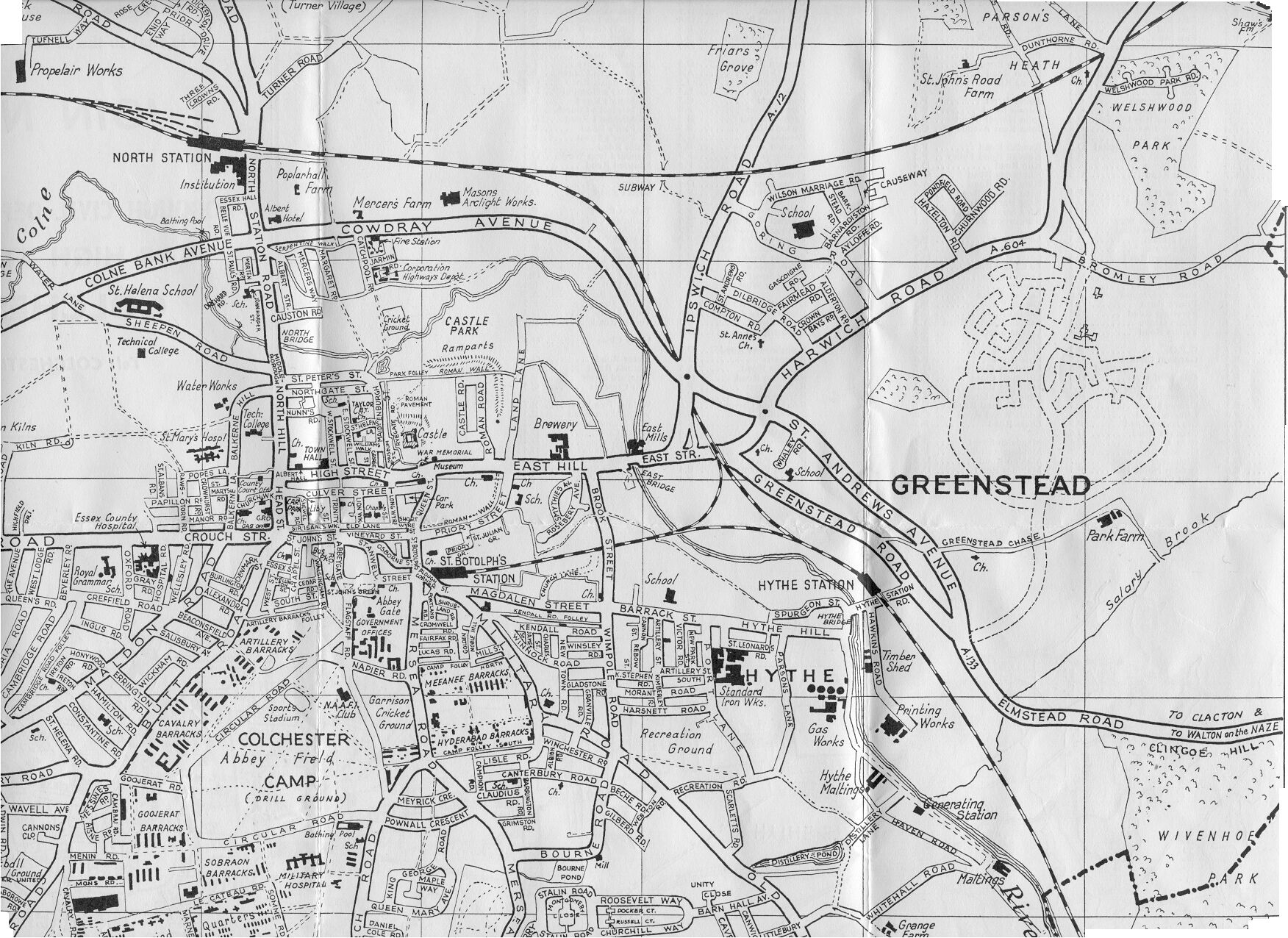
Barnett's Street Plan of Colchester (above), sadly undated, but dateable to 1960 or soon after (the planned layout of the Greenstead estate is shown, giving 1960 as the earliest date. But streets elsewhere, known to have existed in 1963, are not shown) shows development north of Harwich Road, Pondfield Road now marking the northern extent of development south of the railway. The name is presumably taken from the farm, although Pondfield Farm itself was some 400 metres to the South-West.
Non-map sources
Numerous documents in the Essex Record Office show that Parsons Heath, as part of the Manor of Greenstead, was held by the Lucas family at least as far back as 1577/8
Building Plans dated 1911 show that Parson's Heath Farm was then owned by Lord Lucas, and occupied by C.J.Argles.
Street Directories indicate that houses were built on the Bridgebrook Estate in the mid 1960s. Benham, 1964 shows none of the streets, while Benham, 1965 lists the streets, but no inhabitants. Kemp, 1968 shows occupied houses in the streets.
But WHY Bridgebrook Green?
Having traced the land use of Parson's Heath back to 1777, we are no nearer to understanding why it is now called Bridgebrook Green, although we can say it is most likely a recent invention. The earliest reference I can find is dated 12 November 1962, when a meeting of Colchester Council's Building Works Committee discussed Bridgebrook Estate ... formerly referred to as the Hazleton Road site. This is a development on a piece of land purchased following a decision by the Town Development Committee on 1 May 1959.
However, a long-standing resident of Parson's Heath tells me:-
"A series of natural springs which start at Myland Hall, Ipswich Road, run across St John's resurfacing to the rear of St Dominic Road. This brook is called Porters Brook after the farm. Porters Brook runs from St Dominic under the railway line through the Adventure Playground and parallel between Hazelton and Pondfield. It disappears under Tara Court and reappears at Greenstead Slopes. It then resurfaces again at the allotment site besides the Nursery Gardens Estate ie. Booth, Wellesley, Longcroft etc. Porters Brook runs the entire length behind Booth Avenue under and through the back gardens of St David's Close and Wagg's Willow across St Andrew's Avenue and on to The Hythe where it reappears as both a stream/brook and various natural springs on the allotments in that area.

"The original bridge over the brook ie Bridgebrook was the bridge across Harwich Road at Tara Court with a smaller wooden bridge situated at the rear of numbers 63 and 65 Hazelton Road (circled on map) which is a public footpath across to Ipswich Road via Pondfield, Wilson Marriage, Goring, Ipswich Road. The original bridgebrook was for horse and cart, stage coach etc. to take visitors to the coast having first stop at the Seahorse Coaching Inn where the old post office stood beside the natural history museum ie opposite Shepperd's Funeral Parlour. There are no original houses from the days of my grandfather's youth ie 1899 to 1914 evident today in either Hazelton Road or Bridgebrook Close. All of this area was my grandfather's roaming ground having been born at No; 3 Bromley Road prior to moving to Harwich Road in 1908."
This, I think, gives us the answer. Not the original bridge across Harwich Road, which is too far south. But the "smaller wooden bridge" behind 63 and 65 Hazleton Road. No bridge is there now, nor is one shown on any map I have seen, but had Porters Brook been crossed by a bridge at this point, this could well have been the inspiration of the name of the estate.
References
Benham's Colchester Directory, 1964
Benham's Colchester Directory, 1965
Colchester Council Minutes, 1962
Mike Hogg, 2004
private communication
Kemp's Colchester and District Directory, 1968
A Domesday of English enclosure acts and awards, 1978
W.E.Tate
Reading University
Victoria County History of Essex, Vol IX
Institute of Historial Research, 1994
Oxford University Press
Original Records Accessed
Essex Record Office, Chelmsford
- Q/RUm 2/11
- Deposited plan, section and book of reference: Colchester and Bury Railways [1844]
- Q/RUm 2/40
- Deposited plan, section and book of reference: Part of the Eastern Counties Railway east of the Colchester Station, proposed to be made by the Eastern Union Railway Company. [1845]
- Q/RUo 5
- An Act to empower the Eastern Union Railway Company to complete the Eastern Union Railway from the Junction thereof with the Line of the Eastern Counties Railway line at Ardleigh to Colchester [1846]
Essex Record Office, Colchester
- D/B 5/Cr140
- Court roll, 19-20 Elizabeth 1
"Michs. Lawhundred has presentment reflecting jurisdictional tussle between borough and Sir Thomas Lucas, Lord of the manor of Greenstead" [1577-1578] - D/B 6/Pb3/3042
- BUILDING PLANS: Cattle boxes and coal place Parsons Heath Farm Lord Lucas (O); C.J. Argles (A) [1911]
- D/CT 152A
- Greenstead-juxta-Colchester Tithe Award [1838]
- D/CT 152B
- Greenstead-juxta-Colchester Tithe Map [1838]
- D/P 525/28/4
- Map of Parsons Heath Farm in Greenstead and All Saints, Colchester, John Angier, Occupr. [1797]
- T/M 235/1
- Map of estate of Lady Lucas, Great Horkesley, Mile End, Greenstead-Juxta-Colchester, Fordham and Shenfield [1797]
Bridgebrook Today
|
| Bridgebrook Green |
 © 2005 Alan M Stanier (contact details) Last modified