|
|
top
|
|
||||||||||||||||||||
|
|
||||||||||||||||||||||
|
|
||||||||||||||||||||||
|
|
||||||||||||||||||||||
|
|
||||||||||||||||||||||
Introduction
|
||||||||||||||||||||||
|
The Appalachian Mountains, an older and smaller range than the Rockies, stretch nearly 1,500 miles from northeastern Alabama to northern Vermont and through which there are few natural passes. This natural barrier considerably hindered early migration into the interior of North America. By 1750, however, colonial fur traders, explorers, and land speculators had begun to cross over the Appalachians into Kentucky and Tennessee and return to eastern communities with tales of vast and rich lands to the west. The first migrants to cross the Appalachians soon discovered that the mountains were not the only obstacles to westward settlement. Other factors were the Native-American inhabitants and the ongoing dispute between the British and French governments as to who controlled this area. As such, the migrations of British colonists beyond the mountains was a principal cause of the French and Indian War (1754-1761). After the war, migrants crossed the mountains in increasing numbers despite the British government's 1763 proclamation prohibiting settlement beyond the Appalachians. The British knew if the colonials continued their unrestrained encroachment upon Indian territory another Indian war would ensue, a situation they hoped to avoid. However, neither government prohibitions nor army blockades could stop the deluge of settlers that poured west after 1765. Separated by mountain ranges and hundreds of miles from the center of political authority in the East, migrants such as Daniel Boone, and John Sevier followed their own designs and ignored government policies that they deemed to be inconsistent with their interests. Other routes through the Appalachians were also discovered during this time, including the Cumberland Gap, which afforded migrants access to eastern Kentucky and Tennessee. By 1775 the frontier had been pushed beyond the Appalachian Mountains, but renewed war with Indian tribes living in the Old Northwest and the western Carolinas, slowed the westward push into Tennessee. However, these conflicts as well as the American Revolutionary War did not completely curb westward migration. Migrants continued to come west during this time some to escape the ravages of war along the east coast, but most still seeking land and opportunity settled in the western Carolinas and Kentucky. At wars end in 1783, these migrants became the forerunners of American expansion into the Northwest Territory. Source: http://www.answers.com/topic/westward-migration
|
||||||||||||||||||||||
|
|
||||||||||||||||||||||
List of routes
Generally these routes are defined crossing the Appalachian Mountains and having their terminus in present day Kentucky, Tennessee, and West Virginia. |
|
|||||||||||||||||||||
|
LOOKING FOR A SPECIFIC Name, Place, or Keyword ?? |
||||||||||||||||||||||
|
|
Use the “Find” function in the Edit pull down menu. You can also access this function by holding down the Control key while pressing the F key (Ctrl+F) on your keyboard. |
|||||||||||||||||||||
|
|
|
|
|
|
|
|
|
|
|
|
|
|
|
|
||||||||
|
|
|
|
|
|
|
|
|
|
|
|
|
|
||||||||||
|
Road Trip= link to the “Road Trip” page of this route. Image Gallery= link to the “Image Gallery” for this route. Map = link to a map of this route. Info. Link = link to a webpage containing additional facts about this route |
||||||||||||||||||||||
|
FROM / TO |
DESCRIPTIVE INFORMATION |
|||||||||||||||||||||
|
Aurora and Terra Alta Turnpike Info. Link: (1); |
From: Aurora, WV To: Terra Alta, WV |
This 10 mile long route was originally a part of the Kingwood and West Union Turnpike that was later split into the Aurora and Terra Alta Turnpike, Kingwood and Terra Alta Turnpike, and Morgantown and Kingwood Turnpike. Today this route follows the Aurora Pike (Terra Alta Road). See also Morgantown, Kingwood and West Union Turnpike. |
||||||||||||||||||||
|
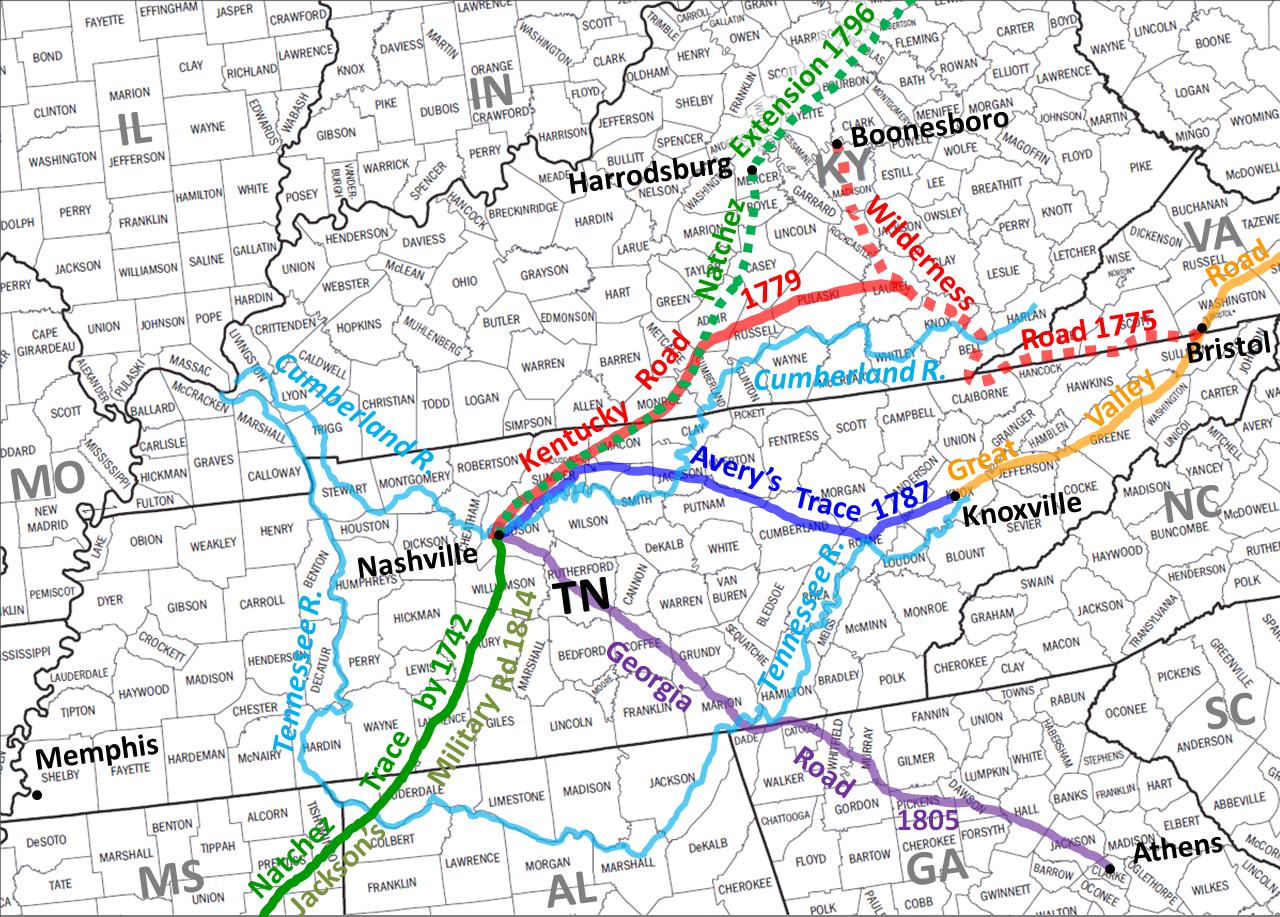
Avery’s Trace Info. Link: (1),(2),(3); Image Gallery: (1),(2);
|
From: Kingston, TN To: Nashville, TN |
A major route used by settlers to reach the Cumberland Settlements in Tennessee from 1788 to the mid-1830s. Named for Peter Avery who had the road laid out along trails used by the Cherokee Indians. Parts of this route became known as the: Nashville Road, North Carolina Military Trace, North Carolina Road, or Cumberland Trace (TN). |
||||||||||||||||||||
|
|
||||||||||||||||||||||
|
FROM / TO |
DESCRIPTIVE INFORMATION |
|||||||||||||||||||||
|
Berkeley and Hampshire Turnpike |
From: Martinsburg, WV To: Frenchburg, WV |
This toll-road was chartered by the State of Virginia in 1851. The route followed these roads from Martinsburg: Tuscarora Pike (CR15, CR18); Hampshire Grade Road (CR7/13, CR13/5); Blue Rock Road, Old Romney Grade (abandoned), WV Route 127, WV Route 29, and Old Martinsburg Road (CR45/9, CR50/10). This road connected with the Northwestern Turnpike (US Rt. 50) at Frenchburg. |
||||||||||||||||||||
|
Berryville and Charles Town Turnpike Info. Link: (1); Map: (1) |
From: Berryville, VA To: Charles Town, WV |
Chartered by the State of Virginia in 1847 this route runs from Berryville along U.S. Route 340 and St. Augustine Avenue into Charles Town. |
||||||||||||||||||||
|
Beverly and Fairmont Road
|
From: Beverly, WV To: Fairmont, WV |
This toll-road was chartered by the State of Virginia in 1852. Today the route follows U.S. Route 250 through the communities of Elkins, Belington, and Philippi, West Virginia. |
||||||||||||||||||||
|
Black Fox Trail
|
From: near Wetmore, TN To: Murfreesboro, TN |
Named for the Cherokee Chief Black Fox, the eastern section of this trail began at the Cherokee settlements along the Hiwassee River. It crossed the Hiwassee River near the mouth of Gunstock Creek and the Tennessee River just above Hiwassee Island. It ended at the mounds that mark an ancient Indian village in the Sequatchie Valley. The western portion continues on as far west as Murfreesboro, Tennessee where it intersects with the Cisca - St Augustine Trail. SOURCE: Meyer, William. E., Indian Trails of the Southeast, Trail 23, p.837. |
||||||||||||||||||||
|
Bolivar and Memphis Trail
|
From: Memphis, TN To: Bolivar, TN |
This Native-American path ran from the Chicksaw Bluffs, at Memphis, to the fortified Indian town in what is now Hardeman County, Tennessee where it connected with the West Tennessee Chickasaw Trail. SOURCE: Meyer, William. E., Indian Trails of the Southeast, Trail 11, p.821. |
||||||||||||||||||||
|
Boone’s Trail (Yadkin to Kentucky) |
From: near Ferguson, NC To: London, KY |
This trail was created by Daniel Boone in 1769 when he began a two-year hunting expedition in Kentucky from his home at Holman’s Ford along the Yadkin River in North Carolina. He probably used this trail when he returned to North Carolina in 1771, and again in the autumn of 1772. He followed the trail in 1773 when he and a group of about 50 emigrants, began the first attempt by British colonists to establish a settlement in Kentucky. This effort was abandoned because of Indian attacks. SOURCE: Meyer, William. E., Indian Trails of the Southeast, Trail 45, p.801. |
||||||||||||||||||||
|
Boone’s Trail to Boonesborough Info. Link: (1),(2),(3) (4); Road Trip: (1) Image Gallery: (1),(2); Map: (1)
|
From: London, KY |
In 1775 Boone blazed a trail that would become known as the Wilderness Road, which went through the Cumberland Gap to eastern Kentucky. Along with a party of about 30 workers, Boone marked a path to the Kentucky River, where he founded Boonesborough. Despite occasional Indian attacks, Boone returned bringing his family and other settlers to Boonesborough on September 8, 1775. See also Daniel Boone’s Trail. |
||||||||||||||||||||
|
Brandonville and Fishing Creek Turnpike Info. Link: (1),(2); Map: (1) |
From: Brandonville, WV To: Fairmont, WV |
This road follows WV Route 26 from the PA–WV state line through Brandonville and Bruceton Mills then along County Route 73 and Interstate 64 to Cheat Lake, WV and then County Route 857 to Morgantown. The final segment to Fairmont follows along U.S. Route 19. This route later became part of the Ohio River and Maryland Turnpike. |
||||||||||||||||||||
|
Brandonville, Kingwood and Evansville Turnpike Info. Link: (1),(2),(3); Map: (1)
|
From: Bruceton Mills, WV To: Fellowsville, WV |
Established by the legislature of Virginia in 1838, this road was later named the Kingwood and Brandonville Turnpike. The route follows current WV Route 26 ran through Kingwood and connected with the Northwestern Turnpike at Fellowsville. |
||||||||||||||||||||
|
Buckhannon and Little Kanawha Turnpike Info. Link: (1),(2): Map: (1) |
From: Buckhannon, WV To: Burnsville, WV |
This toll-road was chartered by the State of Virginia in 1849. It followed current WV Rt. 20 south to French Creek, from there it followed Hoovertown-Beachtown Road and Union Road to Walkersville, and County Rd. 44 to Jacksonville. It then followed along the present course of the Baltimore & Ohio RR through Orlando to Burnsville on the Little Kanawha River. |
||||||||||||||||||||
|
|
||||||||||||||||||||||
|
FROM / TO |
DESCRIPTIVE INFORMATION |
|||||||||||||||||||||
|
Cacapon & North Branch Turnpike |
|
Another name for the Capon and North Branch Turnpike. |
||||||||||||||||||||
|
Capon and North Branch Turnpike |
From: Cumberland, MD To: Capon Bridge, WV |
This 19th century turnpike was built in 1842. It ran from the North Branch Potomac River to the Cacapon River and connected with the Northwestern Turnpike (currently U.S. Route 50). The thoroughfare passed through Frankfort (currently Fort Ashby), Springfield, Millesons Mill, Higginsville, Slanesville, North River Mills, and Cold Stream. Today the original route is made up of segments of WV Route 28, Springfield Pike (Co.Rt. 3), Slanesville Pike (County Rt. 3), and Cold Stream Road (County Rts. 45/20 and 15). |
||||||||||||||||||||
|
Catawba Path |
From: Olean, NY To: Morgantown, WV |
The Catawba Path ran from Ichsua (Olean) on the Allegheny River in New York south through to Morgantown, WV, and on to the Carolinas, Kentucky and Tennessee. It was one of the most important paths in North America. It was known by many names and its extensions served from Florida to Canada and the Mississippi Valley. |
||||||||||||||||||||
|
Catawba Trail |
From: Greenville Co., SC To: Hancock Co., TN |
This route was actually a network of Native-American paths which connected lower and middle Cherokee settlements of the Carolinas with the Overhill Cherokee settlements of eastern Tennessee. American pioneer soldiers and settlers used the Catawba Trail to reach northeast Tennessee no later than 1777. SOURCE: Meyer, William. E., Indian Trails of the Southeast, Trail 33. |
||||||||||||||||||||
|
Charleston and Point Pleasant Turnpike Info. Link: (1); Map: (1) |
From: Charleston, WV To: Point Pleasant, WV |
This 19th century toll-road ran from near the confluence of the Elk and Kanawha Rivers along the north side of the Kanawha River to the Ohio River. Today the route is follows WV Route 25, and WV Route 62. |
||||||||||||||||||||
|
Charleston and Ravenswood Turnpike Info. Link: (1),(2); Map: (1) |
From: Charleston, WV To: Ravenswood, WV |
This road was constructed between 1856 and 1861. It ran from Charleston via Ripley to Sandyville where it connected with the existing Ravenswood and Spencer Turnpike. Most of the route was along current local roads known as of Old US Route 21, WV Rt. 622, County Rt. 21, all which parallel Interstate 77. |
||||||||||||||||||||
|
Info. Link: (1);
|
From: Chattanooga, TN To: Willstown, AL |
This route ran from the Native-American transportation hub at the old Cherokee town of Citico, located at the mouth of the Citico Creek at present Chattanooga, TN. It ended at the Cherokee village of Willstown located north of the present city of Ft. Payne, Alabama. SOURCE: Meyer, William. E., Indian Trails of the Southeast, Trail 72. |
||||||||||||||||||||
|
Cherokee Path
|
From: Charleston, SC To: Monroe Co., TN
|
This ancient Native-American pathway was the primary route from the Atlantic coast to present day Oconee County, SC where Keowee, the principal town of the Cherokee Lower settlements was located. From Keowee, the path branched out to Clayton, Georgia and up to Franklin and Murphy in North Carolina (the Middle settlements) and across to the Cherokee towns in Tennessee (the Overhill settlements). |
||||||||||||||||||||
|
Cisca Road |
From: St. Augustine, FL To: Nashville, TN |
A later name used by white settlers to identify the ancient Indian footpath known as the Cisca - St Augustine Trail. |
||||||||||||||||||||
|
Cisca - St Augustine Trail Info. Link: (1),(2); Image Gallery: (1); Map: (1)
|
From: St. Augustine, FL To: Nashville, TN |
A Native-American thoroughfare from Florida, via Augusta, Athens and Chickamauga crossed the Tennessee River at Running Water. In Georgia it generally follows US Routes 76, 129 and 78. The parts of this overall trail are called the Unicoi Road, Cisca Road, and Nickajack Trail. |
||||||||||||||||||||
|
Cisco and Middle Tennessee Trail Map: (1)
|
From: New Johnsonville, TN |
This trail ran from its intersection with the Lower Harpeth and West Tennessee Trail at Dixie Landing on the Tennessee River in Humphries Co., TN to an intersection with the Cisco and Savannah Trail and the West Tennessee Chickasaw Trail at the old Cisco Indian Village located at the Pinson Mounds State Archaeological Park near Jackson, Tennessee. SOURCE: Meyer, William. E., Indian Trails of the Southeast, Trail 14. |
||||||||||||||||||||
|
Clarksburg and Buckhannon Turnpike Info. Link: (1); Map: (1) |
From: Clarksburg, WV To: Buckhannon, WV |
This 19th century thoroughfare ran from Clarksville, on the West Fork River and Elk Creek, to Buckhannon on the Buckhannon River. Today the route is designated as WV Route 20. |
||||||||||||||||||||
|
Clarksburg and Philippi Turnpike |
From: Clarksburg, WV To: Philippi, WV |
Most of this turnpike followed what is known the “Old Philippi Pike” and “Cherry Hill Road”. In Harrison County it is officially designated as County Rt. 23/9 (Old Philippi Pike), and in Barbour County as County Route 7 (Cherry Hill Road). |
||||||||||||||||||||
|
Clarksburg and Wheeling Turnpike |
From: Clarksburg, WV To: Mannington, WV |
In 1839 the Virginia General Assembly passed an act which incorporated the Clarksburg and Wheeling Turnpike Company to construct a road from Clarksburg in the direction of Wheeling and to connect with the Middletown and Wheeling Turnpike. This connection may have been at Mannington, WV. The route from Clarksburg was about 20.5 miles long and may have run through Lumberport, WV. |
||||||||||||||||||||
|
Cobblestone
Path
|
Built in 1785, this historic pathway runs along the east side of the Bardstown Historic District. Cobblestone Path was placed on the National Register of Historic Places in 1989, due to its importance in the history of transportation to Kentucky. |
|||||||||||||||||||||
|
Cross Roads and Summit Point Turnpike Info. Link: (1); Map: (1) |
From: near Berryville, VA To: Summit Point, WV |
This 19th century toll-road was chartered by the State of Virginia in 1851. Its route ran north from the existing Berryville and Charles Town Turnpike along VA Route 611 (Summit Point Road) into West Virginia where it is called Leetown Road. |
||||||||||||||||||||
|
Cumberland and Great Lakes Trail |
From: Nashville, TN To: Burkesville, KY To: Stanford, KY |
The main trunk (#25) of this pioneer trail was called the Nashville-Lexington Road, (see entry herein under that name). A spur (#25A) of the main route connected with the Tennessee River, Ohio and Great Lakes Trail south of the aforementioned Nashville-Lexington Road. A second prong separated from the main route at Pitman’s Station and proceeded to the Cumberland River, at Burkeville on Cumberland County, Kentucky. SOURCE: Meyer, William. E., Indian Trails of the Southeast, Trail 25, 25A, 25B, p.802. |
||||||||||||||||||||
|
Cumberland and Ohio Falls Trail Info. Link: (1); |
From: Nashville, TN To: Louisville , KY |
The old pioneer road from Nashville to the Falls of the Ohio at Louisville, Kentucky. SOURCE: Meyer, William. E., Indian Trails of the Southeast, Trail 24, p.804. |
||||||||||||||||||||
|
Cumberland Road |
From: Cumberland, MD To: Wheeling, WV |
The Cumberland Road is the name of the first segment of the National Road. This route would replace the Braddock’s Road following roughly the same alignment until just east of Uniontown, Pennsylvania. From there, where Braddock’s Road turned north to Pittsburgh, the Cumberland Road would continue west to Wheeling, West Virginia (then part of Virginia). |
||||||||||||||||||||
|
Cumberland Trace (KY) |
From: Stanford, KY To: Nashville, TN |
As early as 1779 and 1780, many settlers traveled over this pathway turning west from the Wilderness Road (aka. Logan’s Trace) at Logan's Station, (Stanford, KY), to the site that is now Nashville. See also Logan’s Trace and Kentucky Road. |
||||||||||||||||||||
|
Cumberland Trace (TN)
|
From: Rockwood, TN To: Nashville, TN |
This trail, which owes its name to early white settlers, branched from the Tennessee River, Great Lakes, and Ohio Trail in Roane County, TN. The route was much used by the Cherokee in going from the region around the junction of the Clinch and Tennessee Rivers to the central portions of the Cumberland Valley. See also Avery’s Trace. SOURCE: Meyer, William. E., Indian Trails of the Southeast, Trail 26, p.833. |
||||||||||||||||||||
|
Cumberland Turnpike |
From: Kingston, TN To: Carthage, TN |
The Cumberland Turnpike Company operated the Walton Road as a toll road from 1802 to 1811 under charter from the Tennessee General Assembly, but the State resumed control of the road in 1811. |
||||||||||||||||||||
|
|
||||||||||||||||||||||
|
FROM / TO |
DESCRIPTIVE INFORMATION |
|||||||||||||||||||||
|
Daniel Boone’s Trail Info. Link: (1); Road Trip: (1)
|
From: London, KY |
This eastern spur of the Wilderness Road went from near London, KY to Boonesborough on the Kentucky River, a distance of about 45 miles. It was created by Daniel Boone in 1775 upon separating with Benjamin Logan near Hazel Patch, KY. See also Boone’s Trail to Boonesborough. |
||||||||||||||||||||
|
Dunkard Creek Turnpike |
From: Morgantown, WV To: Burton, WV |
This 19th-century toll-road ran from Morgantown on WV Route 100 (Dunkard Avenue) then WV Route 7 west through Blacksville to Burton. |
||||||||||||||||||||
|
|
||||||||||||||||||||||
|
FROM / TO |
DESCRIPTIVE INFORMATION |
|||||||||||||||||||||
|
Emery Road Info. Link: (1);
|
From: Knoxville, TN To: Nashville, TN |
This route followed closely some sections a Native-American path known as Tollunteeskee’s Trail. This road was the first "cut and clear" for a trace as a direct route to the Cumberland settlements occurred in 1785. The system of roads came to be known as the Emery Road and served travelers exclusively for ten years from 1785 to 1795. |
||||||||||||||||||||
|
|
||||||||||||||||||||||
|
FROM / TO |
DESCRIPTIVE INFORMATION |
|||||||||||||||||||||
|
Fairmont and Wheeling Turnpike |
From: Fairmont, WV To: Wheeling, WV To: Moundsville, WV |
This 19th century toll-road ran, in a north-south direction, through the West Virginia communities of, Hundred, and Cameron. The route ran along the south side of Buffalo Creek on current U.S. Route 250 from Fairmont to Mannington, and WV Route 88. The entire route was 71.5 miles between Fairmont and Wheeling, and 6.75 miles for the spur to Moundsville. |
||||||||||||||||||||
|
Federal Road (Cherokee lands) Info. Link: (1); |
From: Savannah, GA To: Knoxville, TN |
Originally called Georgia Road, this route was a federal toll highway passing through the Cherokee Nation in the northern part of of Georgia. From 1805 to the 1840s, the road linked Savannah, Georgia with Knoxville, Tennessee. The road also opened Cherokee lands to settlement. See Georgia Road. |
||||||||||||||||||||
|
Fort Washington-Tennessee Road |
From: Cincinnati, OH To: Barbourville, KY
|
This pioneer route was a part of an Native-American path with an unknown name. As such Meyer named it the Old Road from Fort Washington to Tennessee. The route started at the Indian villages around Sandusky, OH on Lake Eire. It crossed the Ohio River at Fort Washington, near the mouth of the Scioto River, and made its way south across Eastern Kentucky to the Cumberland River where it joined the Wilderness Road. See also Lexington Spur. SOURCE: Meyer, William. E., Indian Trails of the Southeast, Trail 6. |
||||||||||||||||||||
|
|
||||||||||||||||||||||
|
FROM / TO |
DESCRIPTIVE INFORMATION |
|||||||||||||||||||||
|
Georgia Road
|
From: Savannah, GA To: Knoxville, TN To: Nashville, TN
|
The Georgia Road, also called the Federal Road, was a toll road opened in 1805 from Savannah, Georgia across Cherokee Indian lands to Knoxville, Tennessee. Branches also extended to Nashville, Tennessee and Huntsville, Alabama. After improvements in 1819 it was renamed the Federal Road. See Federal Road (Cherokee Lands). |
||||||||||||||||||||
|
Giles, Fayette & Kanawha Turnpike |
From: Pearisburg, VA |
Begun in 1838, the Giles, Fayette & Kanawha Turnpike was completed in 1848. Starting at Pearisburg, in Giles Co., VA, it ran through Peterstown, Red Sulphur Springs, Pack’s Ferry (near present Hinton), Raleigh Court House (present Beckley), and Fayetteville. Then it crossed Cotton Hill and New River, joining the James River & Kanawha Turnpike, (present U.S. 60), at Kanawha Falls. Approximate distance end-to-end 90 miles. |
||||||||||||||||||||
|
Glenville, Ripley & Ohio Turnpike |
From: Weston, WV |
This 100 mile long road was built between 1848 and 1853. It passed through the communities of Linn, Glenville, Arnoldsburg, Spencer, Ripley, ending at the Ohio River. Today this route is U.S. Route 33 |
||||||||||||||||||||
|
Great Indian War & Trading Path (TN) Info. Link: (1),(2); Map: (1) Image Gallery: (1);
|
From: Bridgeport, AL To: Bristol, TN |
The GIW&TP crossed into Tennessee at the Nickajack area, located east of Bridgeport, Alabama. From Chattanooga the route approximates present day US Route 11 to Knoxville. The reminder of the trail in Tennessee is near US Route 11E which became the Knoxville Road in the late 18th century. |
||||||||||||||||||||
|
Great Indian War & Trading Path (WV) Info. Link: (1); Map: (1) Image Gallery: (1); |
From: Peterstown, WV To: Elkins, WV |
139 miles of the GIWP is approximated by US Route 219 from Peterstown to Elkins then a 41 mile section, known as the Seneca Trail to the Maryland border. A branch trail, known as the Shawnee Trail stems from Elkins to Green Spring a distance of about 105 miles. |
||||||||||||||||||||
|
Great Stage Road |
From: Washington, D.C. To: Nashville, TN |
A name used for a 19th century for the transportation route from Washington D.C. south to Knoxville and west to Nashville. The route incorporated several established routes such as the Great Valley Road, the Knoxville Road, as well as the Nashville Road and Old Walton Road, (and later the Cumberland Turnpike). The road south followed much of today’s U.S. Route 11. From Knoxville west the route roughly paralleled modern US Route 70. |
||||||||||||||||||||
|
Guyandotte & Charleston Turnpike |
From: Charleston, WV To: Guyandotte, WV |
This turnpike was constructed in 1854. It ran along the south side of Kanawha River by way of Saint Albans, through Teays Valley to the Ohio River. Today the original road is approximated by U.S. Route 60. |
||||||||||||||||||||
|
|
||||||||||||||||||||||
|
FROM / TO |
DESCRIPTIVE INFORMATION |
|||||||||||||||||||||
|
Hardy and Winchester Turnpike |
From: Hayfield, VA To: Moorefield, WV |
This 19th century toll-road was chartered by the State of Virginia in 1846. It starter about 8 miles west of Winchester where it connected with the Northwestern Turnpike. The route ran for about 50 miles through Wardensville to Moorefield. A 3 mile long branch also ran to Capon Springs. |
||||||||||||||||||||
|
Huntersville and Warm Springs Turnpike Info. Link: (1),(2); Map: (1) |
From: Warm Springs, VA To: Huntersville, WV |
The road from Warm Springs to Huntersville and Warm Springs was constructed around 1835 and is about 25 miles long. Today it is designated as WV Route 39 and VA Route 39. |
||||||||||||||||||||
|
Huttonsville and Huntersville Road |
From: Huttonsville, WV To: Huntersville, WV |
This turnpike was chartered by the State of Virginia in 1850. It is approximately 52 miles in length and approximates current U.S. Route 219, and WV Route 39. |
||||||||||||||||||||
|
|
|
|
||||||||||||||||||||
|
|
||||||||||||||||||||||
|
FROM / TO |
DESCRIPTIVE INFORMATION |
|||||||||||||||||||||
|
|
|
|
||||||||||||||||||||
|
|
||||||||||||||||||||||
|
FROM / TO |
DESCRIPTIVE INFORMATION |
|||||||||||||||||||||
|
James River-Kanawha Turnpike |
From: Buchanan, VA |
In 1825, by act of the Virginia Assembly the trail also known as the Kanawha Turnpike was named the James River and Kanawha Turnpike, soon afterwards the road was completed, along present day U.S. Route 60, as far west as present-day Charleston. It was built to facilitate portage of passenger and freight shipments between the western reaches of the James River via the James River and Kanawha Canal and the eastern reaches of the Kanawha River. |
||||||||||||||||||||
|
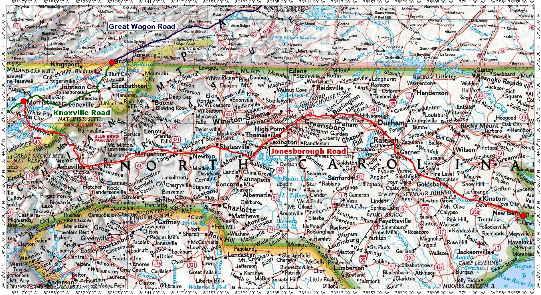
From: New Bern, NC To: Jonesborough, TN |
An early migration route that primarily follows present day US Route 70 from New Bern on the coast of North Carolina through Raleigh and Greensboro and across the Appalachian Mountains to eastern Tennessee where it linked with the Knoxville Road. |
|||||||||||||||||||||
|
|
||||||||||||||||||||||
|
FROM / TO |
DESCRIPTIVE INFORMATION |
|||||||||||||||||||||
|
Kanawha Trace |
From: Fort Chiswell, VA |
This ancient Native-American footpath was a branch of the Great Indian War and Trading Path. The route had been in use by European settlers as early as 1754. It followed the New and Kanawha Rivers to get to and from the Ohio and Shenandoah Valleys. The route enters West Virginia near the town of Peterstown. It mainly follows along the course of the New River to the Falls of New River (where the Kanawha River Dam is now located). At this point the river becomes navigable and some settlers would build flatboats to float down to the Ohio River. |
||||||||||||||||||||
|
Kanawha Turnpike Info. Link: (1); |
From: near White Sulphur Springs, WV
|
In 1785 the Virginia Assembly authorized bidding on a wagon road to from Lewisburg, WV to the lower falls of the Kanawha. In 1790 the road was completed to the Kanawha River along what is now U.S. Route 60. By 1800 the turnpike extended to the Ohio River. The route from Charleston may have been over the thoroughfare later utilized by the Charleston and Point Pleasant Turnpike. By the early-1900s, this road would become commonly known as the "Old State Road." |
||||||||||||||||||||
|
Kentucky Road |
From: Stanford, KY To: Nashville, TN |
Another name for the Cumberland Trace in Kentucky. For additional information see Cumberland Trace (KY). |
||||||||||||||||||||
|
Kingston Pike |
From: Knoxville, TN To: Kingston, TN |
A Native-American trail that became the primary route from downtown Knoxville, formerly James White's Fort, to the western edge of Knox County. It then became a bridle path, going to Sinking Creek. In 1792, Charles McClung surveyed the road from Knoxville to Campbell’s Station. |
||||||||||||||||||||
|
Kingwood & Brandonville Turnpike Info. Link: (1) |
|
The official name of this road is the Brandonville, Kingwood and Evansville Turnpike. |
||||||||||||||||||||
|
Kingwood and Terra Alta Turnpike |
From: Kingwood, WV To: Terra Alta, WV |
The Kingwood and Terra Alta Turnpike is a portion of a road that was formerly known as the "Morgantown, Kingwood and West Union (Aurora) Turnpike". It crossed the Cheat River at Fairfax Ferry and ascended the Briery mountains by an easy grade. Present-day WV Route 7 follows the original route. See also Morgantown, Kingwood and West Union Turnpike. |
||||||||||||||||||||
|
Kingwood & West Union Turnpike |
From: Aurora, WV To: Morgantown, WV |
This is the name under which the original turnpike company was established prior to 1851. After 1851 the name was changed to the Morgantown, Kingwood and West Union Turnpike and was eventually split into the Aurora and Terra Alta Turnpike, the Kingwood and Terra Alta Turnpike, as well as the Morgantown and Kingwood Turnpike. It is not known whether the route ever extended as far west as as the community of West Union. |
||||||||||||||||||||
|
Knoxville Road |
From: Bristol, TN To: Knoxville, TN
|
Developed as a more direct path from the Clinch River to Knoxville by 1792, this road follows much of present day U.S. Route 11E, a distance of about 120 miles. |
||||||||||||||||||||
|
|
|
|
||||||||||||||||||||
|
|
||||||||||||||||||||||
|
FROM / TO |
DESCRIPTIVE INFORMATION |
|||||||||||||||||||||
|
Leading Creek & Buffalo Turnpike |
From: Elkins, WV To: near Macomber, WV |
The Leading Creek & Buffalo Turnpike Company was chartered by the state of Virginia around 1850. In 1860 it reported that the road was 41.5 miles long. The route began at the mouth of the Leading Creek and travelled too Gilman, WV primarily on County Rt. 1. From there the road then ran from up present day US Route 219 to Parsons, WV. From Parsons it proceeded up current WV Route 72 to the mouth of the Buffalo Creek where it connected with the Northwestern Turnpike (US Rt. 50). |
||||||||||||||||||||
|
Lexington-Limestone Road Info. Link: (1);
|
From: Maysville, KY To: Lexington, KY |
This route was originally an Indian-buffalo trail that ran through Lower Blue Licks, KY. The first wagon was taken over it in 1783. It came into prominence after 1792 as an immigrant road to central Kentucky. At Lexington began a road to Nashville. |
||||||||||||||||||||
|
Lexington Spur
|
From: Richmond, KY To: Lexington, KY |
A segment of the eastern spur of the Wilderness Road that branched off of Daniel Boone’s Trail at Richmond, Kentucky and traveled about 25 miles along a Native-American path that would become known as the Fort Washington-Tennessee Road. |
||||||||||||||||||||
|
Logan’s Trace |
From: Mt. Vernon, KY To: Harrodsburg, KY |
The western spur of the Wilderness Road initially created by Colonel Benjamin Logan in 1775. Later a northwest extension ran to the Falls of the Ohio (Louisville). |
||||||||||||||||||||
|
Lower Harpeth and West Tennessee Trail |
From: Nashville, TN To: near New Johnsonville, TN
|
This footpath allowed travel between the Native-American settlements along the Harpeth River as well as those near Nashville in the east and to the Tennessee River in the west. Here several branches of the path connected with routes going west and south. SOURCE: Meyer, William. E., Indian Trails of the Southeast, Trail 17, p.852. |
||||||||||||||||||||
|
|
||||||||||||||||||||||
|
FROM / TO |
DESCRIPTIVE INFORMATION |
|||||||||||||||||||||
|
Maysville Turnpike Maysville–Lexington Turnpike |
From: Maysville, KY To: Lexington, KY |
Originally known as the Lexington-Limestone Road this improved route opened in 1835 as a 64 mile road from Maysville to Lexington built along an old route to New Orleans. AKA Maysville-Lexington Turnpike |
||||||||||||||||||||
|
Martinsburg and Potomac Turnpike |
From: Williamspot, MD To: Martinsburg, WV |
This toll-road was chartered in 1849 opened in 1850. It ran along present day U.S. Route 11 from the Court House Square in Martinsburg to the Potomac River border with Maryland for a distance of about 13 miles.. |
||||||||||||||||||||
|
Martinsburg & Winchester Turnpike |
From: Winchester, VA To: Martinsburg, WV |
The turnpike between Winchester and Martinsburg was established by the state of Virginia in 1848. It ran between both towns on present-day U.S. Route 11. |
||||||||||||||||||||
|
McCulloch’s New Path |
From: Fort Pendleton, MD |
McCulloch's Path was an early 18th Century route utilized by settlers from Colonial Virginia to make their way over the Backbone Mountain ridge of the Allegheny Mountains and on into Western Maryland. Apparently there were two paths with this name. The Old Path, and The New Path. |
||||||||||||||||||||
|
McCulloch’s Old Path |
From: Bloomington, MD To: Ice’s Ferry, WV |
The "Old Path " led from Ice's ferry, which in earliest days was known as "McCullough's Landing," to Bruceton then by way of “Castle Hill” on Backbone Mountain to the North Branch of the Potomac River at Bloomington, MD. |
||||||||||||||||||||
|
Middletown and Wheeling Turnpike |
From: Grafton, WV To: Wheeling, WV |
In 1838 the Virginia General Assembly passed an act which incorporated the Middletown and Wheeling Turnpike Company to construct a road from the Northwestern Turnpike at the Tygart's Valley Bridge, to Middletown in Monongalia County (present-day Fairmont in Marion County), and then to Wheeling. The probable route ran from near present day Grafton, WV up WV Rt. 310 up to Fairmont. Here it would connect with the Fairmont and Wheeling Turnpike. |
||||||||||||||||||||
|
Mississippi and Tennessee River Trail Map: (1) |
From: Camden, TN To: near Eaton, TN |
This Native-American path was utilized by white settlers as a migration route from the Tennessee River further west into what is now Benton, Carroll, and Gibson counties in Tennessee. SOURCE: Meyer, William. E., Indian Trails of the Southeast, Trail 16, p.854. |
||||||||||||||||||||
|
Moorefield and North Branch Turnpike Info. Link: (1) |
From; Green Spring, WV To: Moorefield, WV |
This turnpike was chartered in 1838 by the state of Virginia. It was built to facilitate travel and commerce between the Baltimore and Ohio Railroad at Green Spring on the North Branch Potomac River and Moorefield. Today, Green Spring Road (County Route 1), Harriott-Wappocomo Road (County Route 28/15), and West Virginia Route 28 encompass most of the turnpike's original route. |
||||||||||||||||||||
|
Morgantown and Beverly Road |
From: near Point Marion, PA To: Belington, WV |
This 19th century toll-road started at the PA-WV state line and travelled down U.S. Route 119 through Morgantown. From Browns Chapel it proceeded along several local roads to Evansville where it intersected with the Northwestern Turnpike (US Rt. 50). It then followed WV Route 92 to Belington where it intersected with the Beverly and Fairmount Road. |
||||||||||||||||||||
|
Morgantown and Bridgeport Turnpike Info. Link: (1),(2),(3); Map: (1) |
From: near Cheat Neck, WV To: Bridgeport, WV |
This turnpike was authorized by the state of Virginia in 1849. It started at the PA-WV state line and travelled along County Route 857 to Morgantown. From there it followed along County Route 73 past Fairmont to Bridgeport where it intersected with the Northwestern Turnpike (U.S. Route 50). |
||||||||||||||||||||
|
Morgantown & Kingwood Turnpike |
From: Morgantown, WV To: Kingwood, WV |
This route was established in 1851 as a part of a road that was originally authorized by the State of Virginia between Morgantown, in Monongalia county, and Aurora, in Preston county, via Reedsville, Kingwood and Terra Alta. The original route is approximated by the current Old Kingwood Pike, WV Route 7, and Aurora Pike. See also Morgantown, Kingwood and West Union Turnpike. |
||||||||||||||||||||
|
Morgantown, Kingwood and West Union Turnpike |
From: Aurora, WV To: Morgantown, WV |
In 1851 the name of the Kingwood and West Union Turnpike was changed to the Morgantown, Kingwood and West Union Turnpike and it was eventually split into the Aurora and Terra Alta Turnpike, the Kingwood and Terra Alta Turnpike, as well as the Morgantown and Kingwood Turnpike. The road travelled along present day Old Kingwood Pike, WV Route 7, Aurora Pike and ran through the communities of Reedsville, Kingwood, and Terra Alta. |
||||||||||||||||||||
|
|
||||||||||||||||||||||
|
FROM / TO |
DESCRIPTIVE INFORMATION |
|||||||||||||||||||||
|
Nashville Road |
From: Knoxville, TN To: Nashville, TN |
An early migration route through Tennessee that linked with the Natchez Trace. Segments of this route are also known as Avery’s Trace, Cumberland Trace (Turnpike), and Walton Road. |
||||||||||||||||||||
|
Nashville-Lexington Road |
From: Nashville, TN To: Stanford, KY |
A pioneer trail that is the main trunk of the Cumberland and Great Lakes Trail. This route ran from the vicinity of the settlements around the salt springs at the present site of Nashville to Stanford, KY where it connected with the Tennessee River, Ohio and Great Lakes Trail. SOURCE: Meyer, William. E., Indian Trails of the Southeast, Trail 25, p.802. |
||||||||||||||||||||
|
New River and Southern Trail |
From: Wilkes County, NC |
This route connected the Yadkin River settlements of North Carolina to the Great Valley Road in Virginia and to the New River Gorge into West Virginia. In Mercer County, West Virginia it connected with Kanawha Branch of the Great Indian War and Trading Path also known as the Kanawha Trace / Trail. |
||||||||||||||||||||
|
Nickajack Trail |
From: Bridgeport, AL To: Manchester, TN |
This ancient foot-path started east of Bridgeport, Alabama at Tecallassee, a former Cherokee town located near the border with Georgia, and runs about 50 miles north to Manchester, TN. The Nickajack Trail is a segment of the Cisca-St. Augustine Trail that ran from Florida to Tennessee. |
||||||||||||||||||||
|
North Carolina Military Trace |
From: near Blaine, TN To: Nashville, TN |
This road was built by the military in 1787-1788. It started from the western terminus of Avery’s Trace near the southern end of Clinch Mountain, in what is now Grainger County, Tennessee. The route ran by way of Flynns Creek, the upper crossing of Cumberland River and Dixon Springs, to Nashville. The road officially opened to the public on September 25, 1788. This route is also called, The North Carolina Military Trace of 1788, North Carolina Road, Avery’s Trace, and Cumberland Trace. |
||||||||||||||||||||
|
North Carolina Road |
From: near Blaine, TN To: Crossville, TN |
A part of the Avery’s Trace, this road intersected with the Old Walton Road at Crossville, TN. This route is also called, The North Carolina Military Trace, Avery’s Trace, and Cumberland Trace. For more information see our entry for Avery’s Trace. |
||||||||||||||||||||
|
Northwestern Turnpike Info. Link: (1),(2),(3); Map: (1) Image Gallery: (1);
|
From: Winchester, VA To: Parkersburg, WV |
Originally created in the 1780’s as a route to the Ohio River that would run wholly through Virginia. The road was upgraded to a turnpike in the early 1830’s. It was important for being historically one of the major roads crossing the Appalachians. Today this historical thorofare generally follows U.S. Route 50 across West Virginia. |
||||||||||||||||||||
|
|
||||||||||||||||||||||
|
FROM / TO |
DESCRIPTIVE INFORMATION |
|||||||||||||||||||||
|
Ohio River and Maryland Turnpike |
From: near Glade Farms, WV |
This route began at the PA-WV state line and travelled on current WV Route 26 thorough Brandonville to Bruceton Mills where it connects with old WV Route 73 then Interstate 68 to the intersection with the Morgantown and Bridgeport Turnpike at WV Route 857 and the Cheat River. Then along U.S. Route 119 to Morgantown where it connects with U.S. Route 19 to Fairmont. This segment of was formerly known as the Brandonville and Fishing Creek Turnpike. From Fairmont it runs along the north side of Buffalo Creek for 11 miles to near Mannington. Then follows County Rts. 7 and 21 to WV Route 20 at Smithville. The entire length covers about 103 miles. |
||||||||||||||||||||
|
Ohio River Connection Trail |
From: Harrodsburg, KY To: Louisville, KY |
Also known as the Pioneer Road from Harrodsburg to Falls of the Ohio, this 130 mile route was a part of the Wilderness Road. It started at Harrodsburg, KY then to Brashear's Station at the mouth of Floyds Fork on Salt River, then to the salt works at Bullitt’s Licks, three miles west of Shepherdsville, and finally, to the Falls of the Ohio, now Louisville, where it stopped. |
||||||||||||||||||||
|
Old Walton Road |
From: Kingston, TN To: Carthage, TN |
A name commonly used for the Walton Road. See Walton Road for more information. |
||||||||||||||||||||
|
|
||||||||||||||||||||||
|
FROM / TO |
DESCRIPTIVE INFORMATION |
|||||||||||||||||||||
|
Pamunkey-New River Trail |
From: Orange, VA |
This Native-American trail ran from the Pamunkey River in Virginia to Charlottesville, and Staunton. It then turned in a southwestern direction probably via Clifton Forge and Covington into West Virginia where it met the Kanawha Trace. Much of this route was later followed by the Virginia Turnpike. SOURCE: Meyer, Wm. E., Indian Trails of the Southeast, www.gustavslibrary.com, Trail 48 |
||||||||||||||||||||
|
Pioneer Road: Harrodsburg - Falls of the Ohio Map: (1) |
From: Harrodsburg, KY To: Louisville, KY |
Name used by Meyer for the segment of the Wilderness Road that lead from Harrodsburg, KY to Louisville, KY. See the Ohio River Connection Trail for more information. SOURCE: Meyer, William. E., Indian Trails of the Southeast, Trail 8. |
||||||||||||||||||||
|
Pioneer Road: Lexington - Falls of the Ohio Map: (1) |
From: Lexington, KY To: Louisville, KY |
This route probably ran in a northwesterly direction out of Lexington to present-day Frankfort, KY then into Henry County, KY and via Oldman County, Ky to the Falls of the Ohio now present-day Lousiville, KY. SOURCE: Meyer, William. E., Indian Trails of the Southeast, Trail 9. |
||||||||||||||||||||
|
Princeton & Red Sulphur Turnpike |
From: Princeton, WV |
The routing of this 19th century road followed WV Route 20 to Athens. Then along the Red Sulphur Turnpike (CR 18) to Hill Top. From here it ran down along Island Creek to the New River and crossed at Shanklins Ferry (now abandoned segment) and connected with Shanklins Ferry Crossing Road (CR 23/6). From here to it ran along CR 24/3 & 24 and WV Rt. 12 through Ballard to Red Sulphur Springs. |
||||||||||||||||||||
|
|
||||||||||||||||||||||
|
FROM / TO |
DESCRIPTIVE INFORMATION |
|||||||||||||||||||||
|
|
|
|
||||||||||||||||||||
|
|
||||||||||||||||||||||
|
FROM / TO |
DESCRIPTIVE INFORMATION |
|||||||||||||||||||||
|
Ravenswood & Spencer Turnpike |
From: Spencer, WV To: Ravenswood, WV |
This turnpike was first built in 1851 or 1852, and put under toll in 1853. It ran from Spencer north along WV Route 14 to Reedy. Then west along County Route 1 to Liverpool. Then from Liverpool Road (CR 13) to Sandyville. From here to Silverton it followed several local roads (probably CR 33/12 and 56/1). Then U.S. Route 33 ans CR 2/19 into Ravenswood. The entire route is about 32 miles long. |
||||||||||||||||||||
|
Red and Blue Sulphur Springs Turnpike Info. Link: (1),(2); Map: (1) |
This 19th century turnpike was chartered in 1836 by the State of Virginia. From Red Sulphur Springs the road ran north along WV Route 12 to Alderson. At Palestine it branched onto CR 25 to Blue Sulphur Springs. The entire route is between 35 and 40 miles long. |
|||||||||||||||||||||
|
Russellville-Shawneetown Trail |
From: Shawneetown, IL To: Russellville, KY |
An ancient Indian trail that ran south from Illinois to Logan County, KY where it connected with paths coming from near present-day Nashville and Clarksville, TN, as well as from other parts of the mid-Cumberland Valley. SOURCE: Meyer, William. E., Indian Trails of the Southeast, Trail 41, p.804. |
||||||||||||||||||||
|
|
||||||||||||||||||||||
|
FROM / TO |
DESCRIPTIVE INFORMATION |
|||||||||||||||||||||
|
Salt River Road Info. Link: (1);
|
At: Danville, KY |
Located along the Salt River in Boyle County, KY this road was an important transportation route from 1750 through the 19th century. It was placed on the National Register of Historical Places in 1997. |
||||||||||||||||||||
|
Seneca Trail |
From: Elkins, WV To: Silver Lake, WV |
A 41 mile section of the Great Indian War Path that runs through Tucker County, WV near US Route 219. |
||||||||||||||||||||
|
Shawnee Trail (WV) |
From: Elkins, WV To: Green Spring, WV |
A 105 mile section of the Great Indian War Path that runs through the Seneca Rocks National Recreation Area then north along the South Branch Potomac River. |
||||||||||||||||||||
|
Shepherdstown and Smithfield Turnpike Info. Link: (1),(2); Map: (1) |
From: Shepardstown, WV To: Middleway, WV |
This early turnpike was authorized by the State of Virginia in 1815. From Shepardstown it followed WV Route 480 to Kearneysville then CR 1 through Leetown to Middleway, (then known as Smithfield).
|
||||||||||||||||||||
|
Skaggs Trace Image Gallery: (1);
|
From: Flat Lick, KY To: Stanford, KY |
This was originally a hunters' trail leading from Flat Lick to the Dick's (now Dix River in Lincoln County). It was named for Henry or Richard Skaggs, who hunted in Kentucky as early as 1769. This route later became the western spur of the Wilderness Road initially created by Colonel Benjamin Logan in 1775. See also Logan’s Trace. |
||||||||||||||||||||
|
Smithfield, Charles Town and Harper's Ferry Turnpike |
From: Middleway, WV |
This 19th century toll-road ran from Smithfield, (now Middleway) through Charlestown to Harpers Ferry along the following thoroughfares: Old Middleway Pike, Middleway Pike, Washington Street, Sommerset Boulevard, Halltown Road, Shipley School Road, Allstadts Hill Road, Columbia Street. Today the route approximates WV 51 to Charlestown, and US Route 340 to Harpers Ferry. |
||||||||||||||||||||
|
Staunton - Parkersburg Turnpike |
From: Staunton, VA To: Parkersburg, WV |
A 225 mile road built during the first quarter of the 19th century. It follows much of today’s U.S. Route 250. |
||||||||||||||||||||
|
Sweet Springs and Price's Mountain Turnpike |
From: Fincastle, VA |
This 34 mile long route leaves Fincastle via Main Street and Grove Hill Road (VA Rt. 606) to VA Rt. 615. At Barbours Creek it intersects with VA Rt. 611. Turns right turn at VA Rt. 617 and left onto Sweet Springs Turnpike which becomes Potts Mill Rd. then Mill Branch Rd. to Potts Creek. Turns left onto Potts Creek Road (VA Rt. 18) then right onto Kanawha Trail (abandoned segment) to McDaniel Road (CR 81/1) which intersects with WV Rt. 311. |
||||||||||||||||||||
|
|
||||||||||||||||||||||
|
FROM / TO |
DESCRIPTIVE INFORMATION |
|||||||||||||||||||||
|
Tennessee River, Ohio and Great Lakes Trail Info. Link: (1); Map: (1),(2),(3),(4); |
From: Chattanooga, TN To: Paris, KY |
This Native-American footpath ran north-south through eastern Tennessee and Kentucky. Much of the trail was later followed as the route of the Cincinnati, New Orleans, & Texas Pacific Railway. At the Licking River it connected with the Licking Route and other thoroughfares that continued on to Ohio via Cincinnati. SOURCE: Meyer, William. E., Indian Trails of the Southeast, Trail 29, p.839. |
||||||||||||||||||||
|
|
||||||||||||||||||||||
|
FROM / TO |
DESCRIPTIVE INFORMATION |
|||||||||||||||||||||
|
Unicoi Road Info. Links: (1),(2); Image Gallery: (1); Map: (1)
|
From: Augusta, GA To: Maryville, TN |
Originally a Native-American trading path, known as the Cisca-St. Augustine Trail, this route starts at the highest point of navigation on the Savannah River. It began use in the later 18th century by migrants wanting to reach settlements near Maryville, TN. |
||||||||||||||||||||
|
|
||||||||||||||||||||||
|
FROM / TO |
DESCRIPTIVE INFORMATION |
|||||||||||||||||||||
|
Virginia Turnpike Info. Link: (1); |
From: Richmond, VA |
This road was probably an improved version of the old Richmond Road that joined the Great Wagon Road at Lexington, VA. The route follows present day US highway 60 for its entire length and ends at the source of the Kanawha River in West Virginia where it is known as the Kanawha Turnpike. |
||||||||||||||||||||
|
|
||||||||||||||||||||||
|
FROM / TO |
DESCRIPTIVE INFORMATION |
|||||||||||||||||||||
|
Walton Road Info. Link: (1); Road Trip: (1)
|
From: Kingston, TN To: Carthage, TN |
This migration route to the Cumberland Settlements was created by William Walton in 1795 as an alternative route of Nashville Road. It soon became known as the, Great Stage Road and later the Cumberland Turnpike with markers set every three miles. Portions of this route were known at various times as Avery's Trace, the old North Carolina Road, and Emery Road. |
||||||||||||||||||||
|
Wellsburg and Bethany Turnpike |
From: Wellsburg, WV To: Bethany, WV |
The Wellsburg and Bethany Turnpike was authorized by the State of Virginia in 1849. It ran from Wellsburg, on the Ohio River, along WV Route 67, for about 8 miles to Bethany where it connected with the Wheeling, West Liberty and Bethany Turnpike. |
||||||||||||||||||||
|
Wellsburg & Washington Turnpike |
From: Wellsburg, WV To: near Brooke Hills Park, WV |
This turnpike was authorized by the State of Virginia, in 1834, to run from Wellsburg on current WV Route 27 to the WV-PA state line where it connected with the road to Washington, Pennsylvania now PA Route 844. |
||||||||||||||||||||
|
Weston and Fairmont Turnpike |
From: Weston, WV To: Fairmont, WV |
A toll-road between Weston and Fairmont was authorized by the Virginia Assembly in 1848. Today this route follows U.S. Route 19 via Clarksburg. The entire route is about 46 miles long. |
||||||||||||||||||||
|
Weston & Gauley Bridge Turnpike |
From: Weston, WV To: Burnsville, WV |
This historic road was authorized by the State of Virginia in 1848. The turnpike began in Weston, passed through the salt works at Bulltown, crossed the Elk River at Sutton, then traveled to Summersville, and ended on the Kanawha River. A 10 mile long section of the route between Stonewell Jackson Lake and Burnsville Lake is listed on the National Register of Historic Places. |
||||||||||||||||||||
|
Wheeling, West Liberty and Bethany Turnpike |
From: Wheeling, WV To: Bethany, WV |
This 19th century toll-road was about 16 miles long. It traveled in a north-south direction along WV Route 88 from Wheeling through West Liberty to Bethany where it connected with the Wellsburg and Bethany Turnpike. |
||||||||||||||||||||
|
White and Salt Sulphur Springs Turnpike Info. Link: (1),(2),(3),(4); Map: (1)
|
From: Caldwell , WV |
This turnpike was authorized by the State of Virginia in 1834. The road was 20.5 miles long, commencing near the Greenbrier bridge on the Kanawha Turnpike, and terminating at the Salt Sulphur Springs in Monroe County. It travelled south along current WV Rt. 63 and joined with U.S. Rt. 219 at Organ Cave. From that point this road went through Union to its terminus. |
||||||||||||||||||||
|
Wilderness Road Info. Links: (1); Road Trip: (1) Image Gallery: (1); Map: (1)
|
From: Fort Chiswell, VA To: Louisville, KY To: Lexington, KY |
In 1775, Daniel Boone blazed a trail from Fort Chiswell in Virginia through the Cumberland Gap. The main spur of the trail into Kentucky was widened into a wagon road by 1792 this early migration route through the Cumberland Gap links the Shenandoah and Ohio River Valleys. SOURCE: Meyer, William. E., Indian Trails of the Southeast, Trail #5, p.793. |
||||||||||||||||||||
|
|
||||||||||||||||||||||
|
FROM / TO |
DESCRIPTIVE INFORMATION |
|||||||||||||||||||||
|
|
|
|
||||||||||||||||||||
|
|
||||||||||||||||||||||
|
FROM / TO |
DESCRIPTIVE INFORMATION |
|||||||||||||||||||||
|
|
|
|
||||||||||||||||||||
|
|
||||||||||||||||||||||
|
FROM / TO |
DESCRIPTIVE INFORMATION |
|||||||||||||||||||||
|
|
|
|
||||||||||||||||||||
|
|
||||||||||||||||||||||
|
|
||||||||||||||||||||||
Image
Gallery
During our research we have collected images and photographs that are of general interest to a variety of historic American roads, trails and migration routes. Some of them are presented on this website because we believe they tend to provide the reader with additional information which may aid in the understanding of this topic as well as our ancestors past lives. |
Migration Routes to Kentucky and Tennessee 1779-1796 Click on image to enlarge |
|||||||||||||||||||||
|
Use this LINK to see the “Image |
|
Gallery” that pertain to this topic. |
||||||||||||||||||||
|
|
||||||||||||||||||||||
|
|
|
|
||||||||||||||||||||
|
Use the power of Google™ to find more interesting images about this topic. This button will link you to the Google Images Search page. Enter the topic |
|
you are searching in the box and click “Search Images”. At the “Images” display page you will see the image, as well as the website of which it is associated. |
||||||||||||||||||||
|
|
||||||||||||||||||||||
|
|
Inyernet resources
|
|
||||||||||||||||||||
|
The Google search engine button and following web sites may provide |
|
you with additional information to assist your research about this topic. |
||||||||||||||||||||
|
|
||||||||||||||||||||||
|
· Migration Routes, Roads & Trails · Historical U.S. roads and trails - Wikipedia · U.S. Historical Maps - Perry-Castañeda Collection · Early American Roads and Trails · US Migration Trails and Roads – Family Search Wiki · American Migration Trails: Eastern United States · Historic trails & roads in the U.S.A. by state - Wikipedia |
· American Migration Fact Sheets · Map guide to American migration routes,1735-1815 · Westward Expansion: Trails West · Migration Message Boards – Ancestry.com · The African-American Migration Experience · Migration Trails – map of many U.S. trails · Migration Information & Maps By Ethnic Group · United States Research Wiki – Family Search |
|||||||||||||||||||||
|
|
||||||||||||||||||||||
|
· Tennessee Migration Routes - Family Search Wiki · Kentucky Migration Routes - Family Search Wiki · West Virginia Migration Routes - Family Search Wiki · Historic trails and roads in Tennessee - Wikipedia · Historic trails and roads in Kentucky - Wikipedia · Historic trails and roads in West Virginia - Wikipedia |
· List of turnpikes in Virginia and West Virginia · From Trail to Railway Through the Appalachians · Transportation in Early Middle Tennessee · History Of Fayette Co,, WV, Beginning of Public Highways · Wilderness Road to Kentucky, by William A. Pusey |
|||||||||||||||||||||
|
Download a free 2-page Fact Sheet |
|
about American migration routes. |
||||||||||||||||||||
|
|
|
|
||||||||||||||||||||
|
The following Link will take you to our library of genealogy reference books. Here you will find books about historic American roads, trails, and paths. In addition, there are texts that pertain to ethnic and religion groups, history, geography as well as other books that will assist you with your research. |
||||||||||||||||||||||
|
This Link will take you to our |
|
collections of reference books. |
||||||||||||||||||||
|
|
||||||||||||||||||||||
About this webpage
|
||||||||||||||||||||||
|
CONTACT INFORMATION
We do like to hear from others who are researching the same people and surnames. We
need your help to keep growing! So please Email
photos, stories, and other appropriate information about this topic.
RULES OF USE We only ask that if you have a personal website please create a link to our Home Page. -- This webpage was last updated on -- 01 March 2013 |
||||||||||||||||||||||
|
|
|
|
||||||||||||||||||||


.JPG)
%20Part%201.JPG)
%20Part%202.JPG)
.JPG)
.JPG)
.JPG)
.JPG)
.JPG)
.JPG)
.JPG)
.JPG)
.JPG)
.JPG)
.JPG)
.JPG)
.JPG)
.JPG)
.JPG)
.JPG)
.JPG)
.JPG)
.JPG)
.png)