A.2.1.e. William Berry
|
William Berry was born about 1743 or 1744 on his parent’s farm, which was situated in the upper reaches of a tributary of the North Fork of the James River within the Borden Tract in Augusta County, Virginia. No documentation exists for any specific events that may have occurred to him during his childhood, but indirect evidence makes it clear that he grew up in a rural frontier environment on the outer fringes of British colonization in the mountains of Virginia. Things were quickly changing for these English colonists, though, and during the late 60s and early 70s (the 1760s and 1770s) political winds favored westward expansion of these frontier English settlements that had previously been geographically confined by French North American colonial claims. William’s father, Thomas Berry Senior, had been born in Northern Ireland in 1718 and migrated to the American colonies, probably through Pennsylvania with his father, the elder James Berry, during the 30s and 40s. During the 60s, after the passing of his father, the elder James Berry, and in response to the ever changing geopolitical climate, Thomas Sr. gradually divested himself of his Augusta County land holdings and moved again. By 1770 he had moved his family to the Holston River valley in southwestern Virginia, and the direct documentary evidence for his son William Berry begins during this period. |
|
|
Timeline of William Berry and Mary ? (Unknown Last Name)
|
~175212 |
Esther
(Berry) McCord
Family Record |
||||||||||||||||||
|
The Cummings
Petition, Location of the Homes of the Signers |
|||||||||||||||||||
|
Washington
County, Virginia Will Book 1, page 34 |
|||||||||||||||||||
|
~1776525 |
Washington
County, Virginia Will Book 1, page 34 |
||||||||||||||||||
|
~1778525 |
Washington
County, Virginia Will Book 1, page 34 |
||||||||||||||||||
|
19 May 177856 |
Annals of
Southwest Virginia 1769-1800 |
||||||||||||||||||
|
22 Nov. 178056 |
Annals of
Southwest Virginia 1769-1800 |
||||||||||||||||||
|
5 Feb. 1781525 |
Washington
County, Virginia Will Book 1, page 35 |
||||||||||||||||||
|
19 June 1781525 |
Washington
County, Virginia Will Book 1, page 35 |
||||||||||||||||||
|
Washington
County, Virginia Will Book 1, page 35 |
|||||||||||||||||||
|
30 Aug. 178169 |
Washington
County, Virginia Survey Record Book 1, page 171
12th Apl. 1782 |
||||||||||||||||||
|
1782491 |
Washington
County, Virginia Personal Property Tax Lists |
||||||||||||||||||
|
12 April 178269 |
Washington County, Virginia Survey Record Book 1, page 179
12th April 1782 |
||||||||||||||||||
|
13 April 178269 |
Washington County, Virginia Survey Record Book 1, page 39
13th April 1782 |
||||||||||||||||||
|
11 May 178269 |
Washington County, Virginia Survey Record Book 1
11 May 1782 |
||||||||||||||||||
|
1783491 |
Washington
County, Virginia Personal Property Tax Lists |
||||||||||||||||||
|
Washington County, Virginia Will Book 1, page 59
David Cowan |
|||||||||||||||||||
|
1784491 |
Washington
County, Virginia Personal Property Tax Lists |
||||||||||||||||||
|
11 Aug 1787491 |
Washington
County, Virginia Personal Property Tax Lists |
||||||||||||||||||
|
20 Oct 1788491 |
Washington
County, Virginia Personal Property Tax Lists |
||||||||||||||||||
|
4 July 1789491 |
Washington
County, Virginia Personal Property Tax Lists |
||||||||||||||||||
|
4 Aug. 1790491 |
Washington
County, Virginia Personal Property Tax Lists |
||||||||||||||||||
|
25 July 1791491 |
Washington
County, Virginia Personal Property Tax Lists |
||||||||||||||||||
|
8 June 1792491 |
Washington
County, Virginia Personal Property Tax Lists |
||||||||||||||||||
|
9 May 1793491 |
Washington
County, Virginia Personal Property Tax Lists |
||||||||||||||||||
|
1794491 |
Washington
County, Virginia Personal Property Tax Lists |
||||||||||||||||||
|
30 April 1795491 |
Washington
County, Virginia Personal Property Tax Lists |
||||||||||||||||||
|
1797491 |
Washington
County, Virginia Personal Property Tax Lists |
||||||||||||||||||
|
1798491 |
Washington County, Virginia Personal
Property Tax Lists |
||||||||||||||||||
|
16 Dec. 1798120 |
Washington
County, Virginia Will Book 2 |
||||||||||||||||||
|
1799491 |
Washington
County, Virginia Personal Property Tax Lists |
||||||||||||||||||
|
1801491 |
Washington
County, Virginia Personal Property Tax Lists |
||||||||||||||||||
|
29 Mar. 1802575 |
Washington
County, Virginia Deed Book A, page 379 |
||||||||||||||||||
|
21 March 1804491 |
Washington
County, Virginia Personal Property Tax Lists |
||||||||||||||||||
|
17 May 1805491 |
Washington
County, Virginia Personal Property Tax Lists |
||||||||||||||||||
|
1806530 |
Washington
County, Virginia Personal Property Tax Lists |
||||||||||||||||||
|
1807530 |
Washington
County, Virginia Personal Property Tax Lists |
||||||||||||||||||
|
1809530 |
Washington
County, Virginia Personal Property Tax Lists |
||||||||||||||||||
|
1810538 |
Federal Census,
Washington County, Virginia, page 206 |
||||||||||||||||||
|
1810530 |
Washington
County, Virginia Personal Property Tax Lists |
||||||||||||||||||
|
29 Sept. 1832494 |
Revolutionary
War Pension & Bounty Land Warrant Application Files |
Analysis of the Timeline
|
There is no primary source material documenting William Berry’s life until the mid 1770s, when he was already a young man. Consequently, information identifying the date and place of William Berry’s birth must be discerned indirectly from limited evidence. Based on the birth of his first child around 1775 and calculations based on a family history record from one of his sisters, William Berry’s birth is estimated to have taken place between 1743 and 1744. A late 19th family history record that ultimately can be sourced to Barbara Berry’s youngest sister, Esther (Berry) McCord, provides the birth date of Barbara’s father (Thomas Berry, Sr.), the identity of both of his wives and all of the children from both marriages, as well as their birth order. This record identified James Berry as Thomas Berry’s oldest child, followed, in order, by Barbara Berry and Thomas Berry. Although no birth dates were given, an analysis of a 1763 Augusta County, Virginia deed record can be used to accurately approximate the birth dates of the first three children. In this land transfer, Thomas Berry Sr. sold a recently purchased parcel of land to his oldest son James on 21 June 1763, and the conveyance was legally witnessed by James’ younger brother Thomas Berry. The importance of this record lies in the fact that, in order to legally serve as a witness in a sanctioned county government proceeding such as this, the younger Thomas Berry must have been at least 21 years of age. Consequently, since Thomas was at least 21, his brother James Berry had to have been several years older, and the date of the land sale can be used to calculate a close approximation of not only their birth dates, but also that of their sister, Barbara Berry, who was born between them. Basic biology requires an absolute minimum time of nine months between the births of James and Barbara, as well as between Barbara and Thomas, so, at a bare minimum, the least amount of time between the birth of James Berry and his younger brother Thomas, was 18 months. From a practical point of view, however, new pregnancies probably did not commence immediately after a birth. Some time, perhaps a few months, most likely separated the birth of a child and the onset of pregnancy for the next child. Assuming a minimum interval between pregnancies of three months, which might be an underestimate, the time between the birth of James and Thomas Berry can be extended from 18 months to a bit more reasonable time span of 24 months. Given this assumption, the younger Thomas Berry, in order to have been at least 21 years old in 1763, could have been born no later than 1742, his older brother James could have been born no later than 1740, and, within this logical construct, Barbara Berry must have been born in 1741. If the interval between pregnancies was more than three months, then the birth dates of each of these children could be pushed back in time another year to 1739, 1740 and 1741, respectively. The totality of the indirect evidence, thus, provides a logical framework for concluding that James Berry was probably born about 1739, his next youngest sibling, Barbara Berry, in 1740 and his next oldest first brother, Thomas Berry, in 1741. From the time they got married, it appears that Thomas Berry, Sr. and his first wife had children at regular intervals, almost on an annual basis. If they continued this regular succession of births after their first three children, then their next child, Mollie, would have been born about 1742 or 1743 and William would have been born in 1743 or 1744. His mother passed away sometime between 1744 and the early 1750s, so his father remarried and started a second family.12,256
|
|
Given this estimated birth date, his birth place is still a bit of a mystery. Since his father appears to have moved from southeastern Pennsylvania to Augusta County, Virginia sometime between 1742 and 1748, the only conclusion that can reached about William Berry’s birth place is that it occurred in Pennsylvania or Virginia. What is known with certainty, though, is that William Berry grew up on his parent’s farm in the upper reaches of a tributary of the North Fork of the James River within the Borden Tract in Augusta County Virginia.1074,1076
|
|
The next milestone in William’s life was his marriage, but, unfortunately, no records have been found that document this occasion. The birth date of William’s oldest son, Thomas Berry, who was clearly named after William’s father, is the only firm chronological reference point, but even that date is not known with absolute certainty. The young Thomas Berry’s birth is estimated to have taken place about 1775 based on his first appearance in Washington Personal Property Tax records in the “white males above the age of 16” category bracket in 1791 – ten years after his father’s death. The Virginia tithable lists recorded free white males at least sixteen years of age, basically documenting men who were potentially part of the colonial work force. This Thomas Berry does not appear in that category in the eight previous tax years, but nearly every year after that until his apparent age is about 22, at which time he appears in the tithable records on his own. While not definitive in nature, it is logical to assume that young Thomas Berry Jr. probably turned 16 in the year of his first appearance in the county tax records. Based on the typical marriage practices of the day, it can be safely assumed that William Berry had probably gotten married a year or two before that birth, placing his marriage in 1773 or 1774.491
|
|
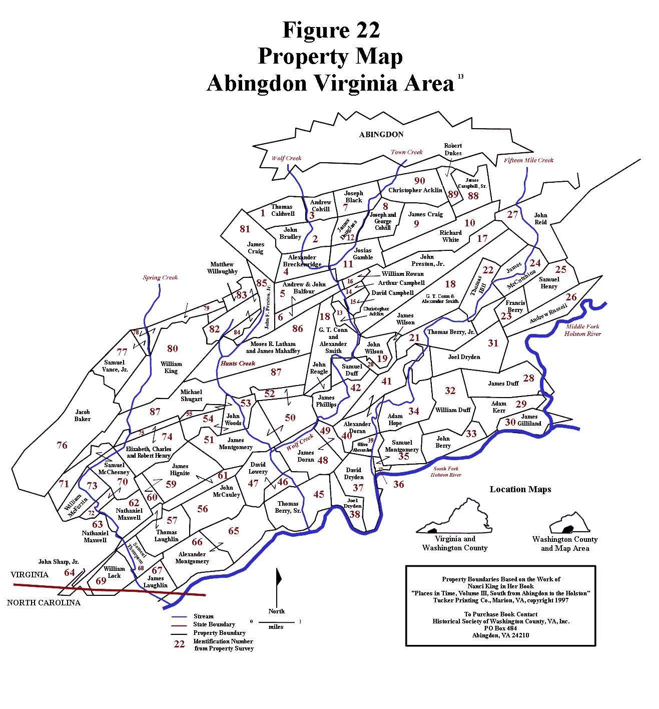
As the map progression in Figure 65 clearly demonstrates, the southern part of Augusta County was split off to form Botetourt County in 1770. Sometime during that year, Thomas Berry, Sr., William’s father, met the legal requirements for settlement on his new property located along Wolf Creek, a tributary of the South Fork of the Holston River (Figure 22), in the part of Botetourt County that lay within the confines of modern day southwestern Virginia. Based on William Berry’s estimated birth date of 1743/1744, William would have been about 25 or 26 years old at the time, so it does not seem unlikely that he would have made the move to southwestern Virginia independently from his parents. The first definitive trace of William Berry can be found in the 1772 Botetourt County tithables, where he appears on Robert Doak’s list in Captain Campbell’s militia company. Robert Doak had two tithable lists that year, one that covered the areas of responsibility for Captain David Looney and Captain Anthony Bledsoe’s militia companies, and the other for Captain Campbell’s militia company. An examination of these tithable lists and the associated militia companies is necessary at this point in order to understand where William Berry was living at that time. |
Military & Civil Organization and the Botetourt County Tithable Lists
|
During the early 1770s, taxes and tax data for the English settlers living within Botetourt County, Virginia were collected and recorded, and, although not all of the records have survived to the twenty first century, a number of them have. These particular taxes, called tithables, were levied upon qualifying individuals (primarily, free white males at least 16 years of age) who lived within a defined geographic area, here referred to as a tithable (or tax) district. General descriptions of the areal extents of these tithable districts and the men charged with the responsibility of maintaining the lists of people living within the confines of these areas are also available from colonial records. A prominent person within each district was assigned the responsibility by the county legislative body to identify all potential tax payers, and, presumably, to collect the taxes. Rather than affecting only land and property owners, as a property tax does, the tithables functioned as a tax imposed upon individuals who actually lived within a specified area, whether they owned the land on which they lived or not. Basically, this was a “head tax” – a tax on whatever qualifying individual was living in a specific area, so absentee landowners were not included on tithable lists.
|
|
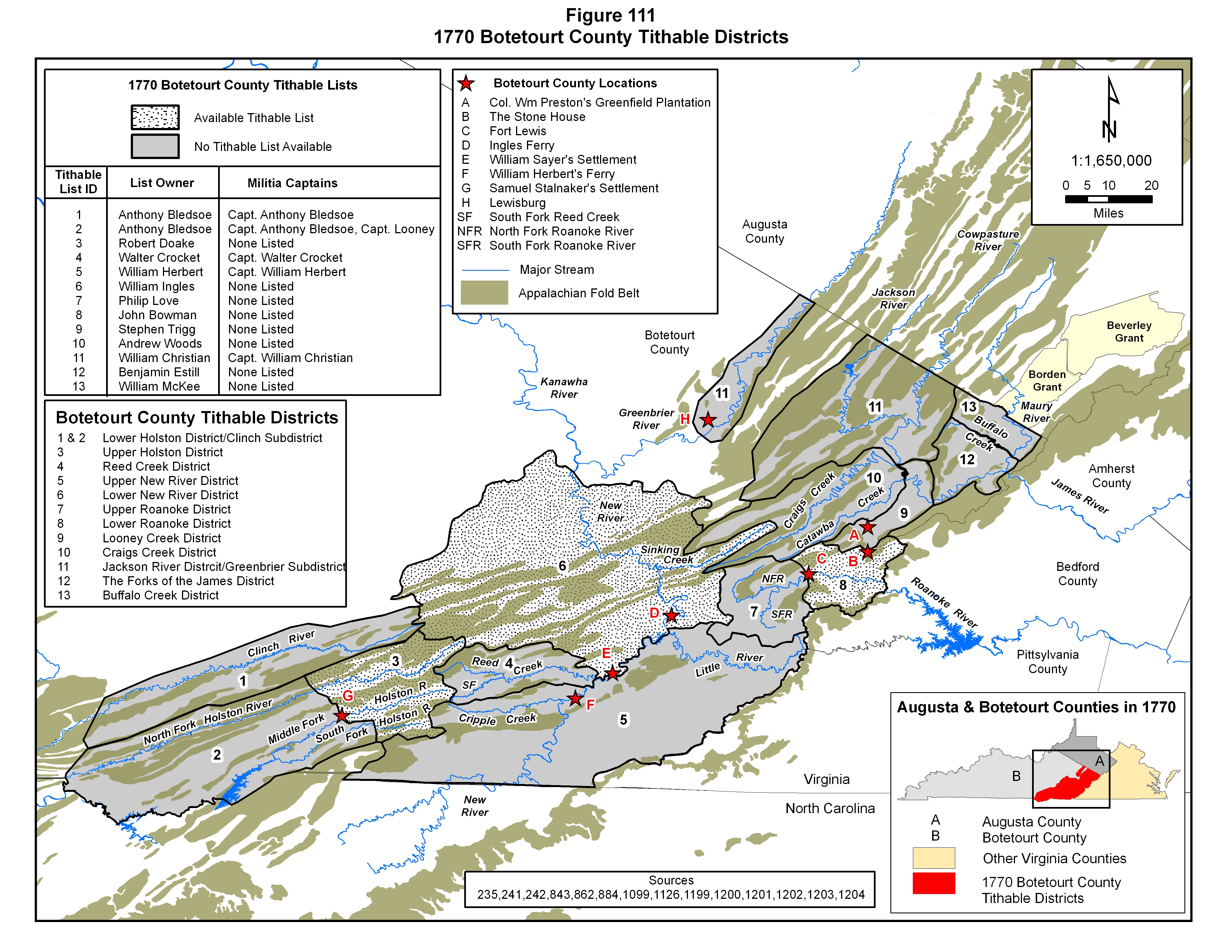
When Botetourt County was created in 1770, one of the first orders of business for the county court was to establish taxation districts with the ultimate purpose of generating income from the county residents to fund various government services. Unfortunately, the Botetourt County tithable records from only three of the twelve tithable districts established that year have survived to the present day, although most of the tithable records for 1771 and 1772 are still extant. (Figure 111) Another critical level of organization within each county was the militia company. Since the colonial frontier was a dangerous place, by provincial government decree, all able bodied males were required to join the militia, and while militia units were organized on a county basis, overall command and control was in the hands of the royal provincial executive and legislative bodies, and, in particular, the royal governor. On the local level, militia units were organized into companies composed of settlers living within loosely-defined geographic areas within each tax district. Each company was commanded by a militia captain operating within a strict chain of command. In the early 1770s, depending on its size, area extent and population density, each tithable district possessed one or more militia companies within its boundaries. The militia captains commanding these companies provided their political and military leaders with a list of the taxable males, and, in most cases, heads of families, who lived within their assigned areas. Without a doubt, the county court designated tithable lists were intimately interwoven with the state-operated militia organizations. The records from these civil and military organizations serendipitously provided succeeding generations with valuable information on the families moving into and through these areas during this era of mass migration.56,241,242,864,1151,1152
|
|
During the colonial period, topographic elements were critically important in the creation of political boundaries. Perhaps the most striking of these elements were the mountain uplifts of the Appalachian fold belt that characterized the western part of the Virginia colony. The Holston, New, Staunton and James Rivers, the principal streams forming the hydrologic framework of Botetourt County, are found within a region characterized by a markedly parallel series of northeast/southwest aligned ridges and valleys. This distinctive area falls within the Ridge and Valley Physiographic Province of the Appalachian Fold Belt Mountains. So, superimposed upon the mountainous topographic infrastructure can be found a hydrologic framework of stream drainage basins and the drainage divides separating them. The boundaries, locations and geographic extent of these natural hydrologic features, the drainage basins and divides, can easily be recognized on the ground, as long as the streams themselves can be correctly identified, and are unmistakable to anyone conducting any kind of ground movement. The unique combination and easily understood characteristics of naturally occurring, topographic and hydrographic terrain elements, consequently, provided a firm basis for the establishment of legal boundaries, basic landmarks and directional elements for the human occupants of this region, and this particularly true of the Botetourt County court when it established the boundaries and extents of the tithable districts.311
|
|
On the 10th of May in 1770, at one of the first meetings of the court for the newly established Botetourt County, the boundaries of the tithable districts were defined and list “owners” were assigned to each district. Based on the legal descriptions provided by the court, and a comparison to the basic hydrology of the area, shown in Figure 111, the district boundaries conformed to the major drainage basins of the region. The tithable districts of Stephen Trigg, Andrew Woods, William Christian, Benjamin Estill and William McKee were defined within the James River drainage basin, except for an inclusion of the settlements along the Greenbrier River in Botetourt County which were placed within William Christian’s list. John Bowman and Philip Love’s districts were located within the Staunton River drainage basin. The districts of Walter Crocket, William Herbert and William Ingles were defined as being within the New River drainage basin, and Anthony Bledsoe and Robert Doak’s districts were situated within the Holston River drainage basin. The two tithable districts within the Holston basin, covering the various forks of the Holston River drainage basin (the North, Middle and South Forks, as well as the Clinch River), are the focus of this part of the report. Robert Doak was assigned responsibility for the area that extended from the head of Reed Creek to a place called Stalnakers, and Anthony Bledsoe was assigned the area from there to the lower end of the territory generally perceived to belong to the Royal Colony of Virginia.241,242
|
|
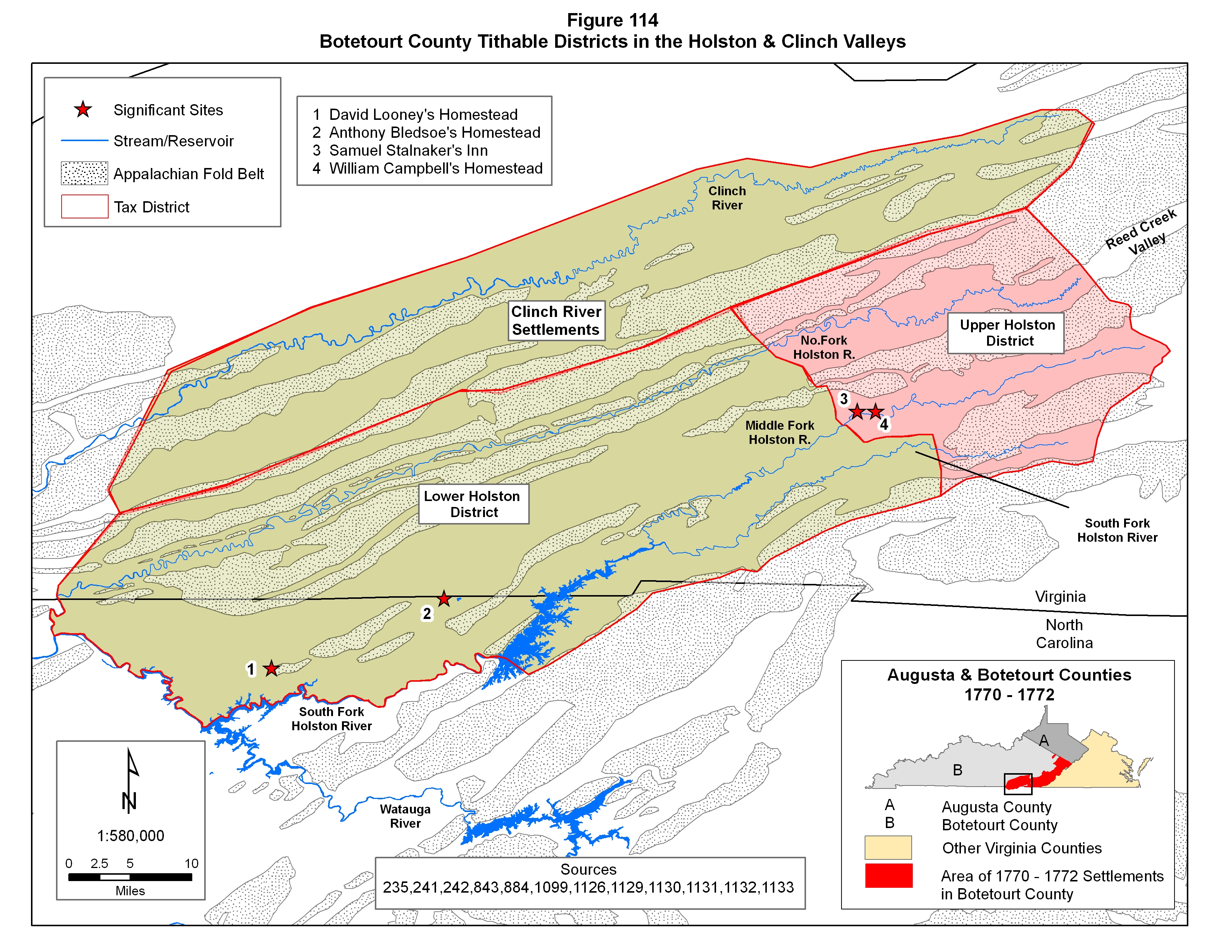
Robert Doak’s tithable district, here referred to as the Upper Holston District, started at the headwaters of the three forks of the Holston River drainage system (the North Middle and South Forks), and corresponded to one of the major corridors of migration during this time period. The headwaters of the Middle Fork of the Holston River lie on the opposite side of the drainage divide from Reed Creek, an upper tributary of the New River drainage basin, and it is this area that the Botetourt Court defined as the upper limit of Robert Doak’s area of responsibility. It then extended downstream approximately to 7 Mile Ford, a prominent river crossing on the Middle Fork as shown in Figures 111, 114 and 115 and it was in this vicinity that Samuel Stalnaker had established his residence long before Botetourt County came into existence. In 1752 Samuel Stalnaker began operating a government-sanctioned tavern at his home which was located on this major river crossing near the present day town of Chilowie. The location of this cultural feature was widely known to travelers and residents of the area, and, obviously, to the Botetourt County court. Captain William Campbell, one of the political and military leaders of the county, also settled nearby this area, a short distance upstream from the ford, and according to the 1771 and 1772 Botetourt County militia lists, he served as the captain of the local militia company for the residents of this tithable district. His militia district, thus, extended from the upper reaches of the Holston drainage basin to the vicinity of 7 Mile Ford.56,241,242,843,989,1074,1075,1076,1129,1130,1133
|
|
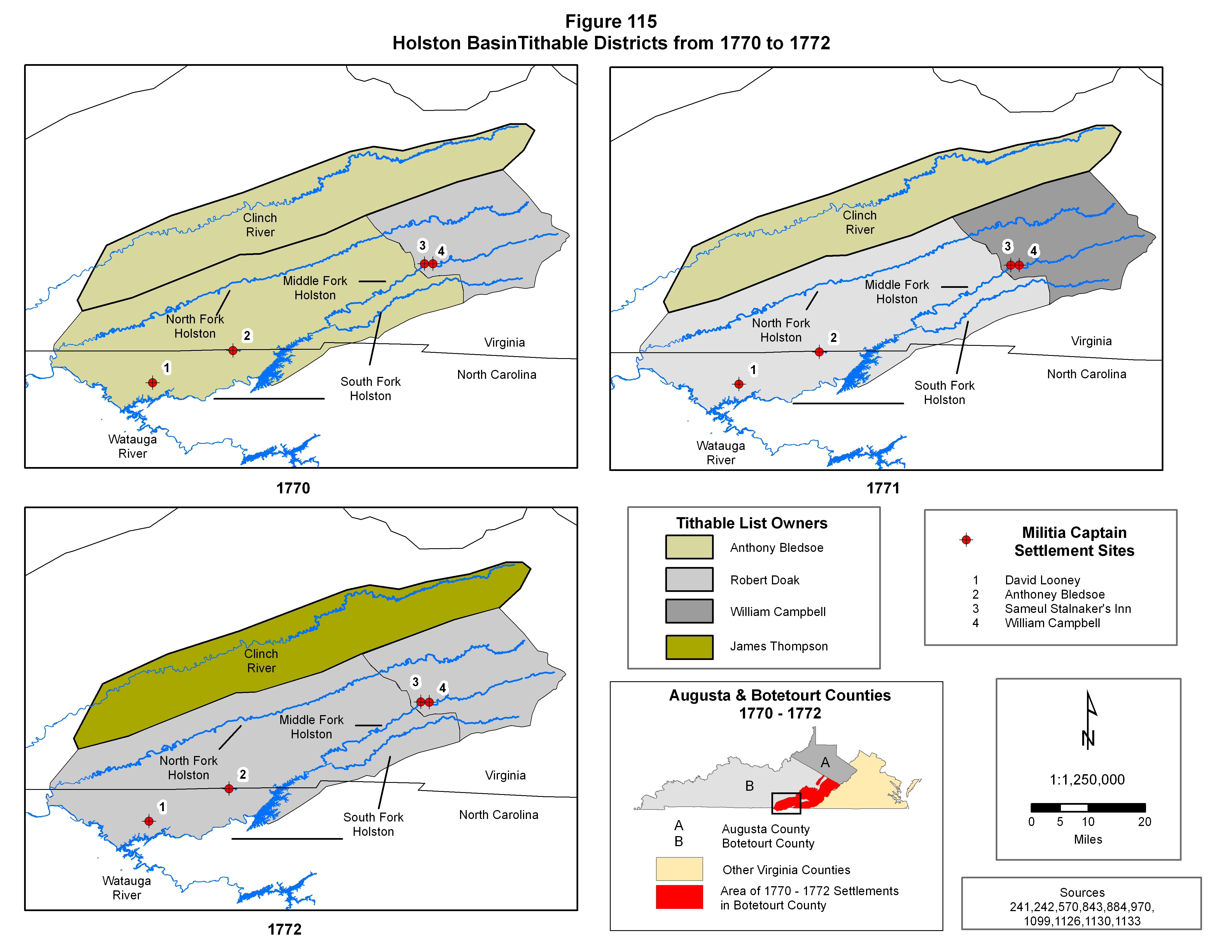
The other tithable district in the Holston valley was assigned to Anthony Bledsoe and extended from Stalnakers southwestward to the lowest Virginia settlements. This area is here referred to as the Lower Holston Valley tithable district, and is shown in Figures 111, 114 and 115. In 1770 it also included the Clinch River settlements, which were scattered and few at the time. It wasn’t until 1772 that enough settlers had moved into the Clinch River valley to justify the creation of a separate tithable district to cover that area. The early settlers that moved into the lower Holston Valley district considered the “natural boundary” between North Carolina and Virginia to be the convergence of the South Fork of the Holston River with the Watauga River and the northwestward extension of this river boundary to the point where the North and South Forks of the Holston River converged. (Figures 111, 114 and 115) This river boundary was an easily recognizable terrain feature, and this is where the Botetourt County court assumed the Virginia/North Carolina boundary to be. When the actual boundary was eventually defined farther north a few years later, along a rather straight east/west-oriented surveyed line that had no relationship to the terrain, many settlers who had long considered themselves to be Virginians, instantly became North Carolinians. In 1770, though, the hydrographic and topographic elements were still the deterministic elements in defining the southern extent of this tithable district in Botetourt County. Captain Anthony Bledsoe was selected to manage the tithable lists from this area because of his military and political connections as much as the fact that he lived within this district. His home was located near Evan Shelby’s Sapling Grove settlement site at present day Bristol, Tennessee. As the 1771 and 1772 Botetourt County tithable lists show, he also served as a militia captain for one of the two militia companies that fell within the Lower Holston Valley tithable district. Captain David Looney, who also lived in the area, was the commander of the other militia company in this district, and his homestead was located along Muddy Creek, a few miles upstream from where that stream empties into the South Fork of the Holston River in present day Sullivan County, Tennessee. Figures 114 and 115 shows the various terrain elements of the Holston Valley area and their relationships to the legal boundaries established by the county courts, the boundaries and extents of the tithbale districts as well as all of the notable sites mentioned in the various Botetourt County court tithable list and district descriptions from 1770 through 1772. From an examination of the tithable records it appears that Captain David Looney’s militia company covered the area that eventually became Tennessee, while Captain Bledsoe’s company covered the rest of the Lower Holston District. After 1772, Fincastle County was formed from part of Botetourt County (see Figure 65), and the entire Holston valley, particularly the Lower Holston District, where many Berry family members had recently migrated from the Augusta County area, fell within the new county, which meant, of course, that they no longer appeared in Botetourt County records. Unfortunately, few, if any, of the Fincastle County tithable records have survived to the present day.56,311,864,989,1129,1130,1131,1132,1135,1136 |
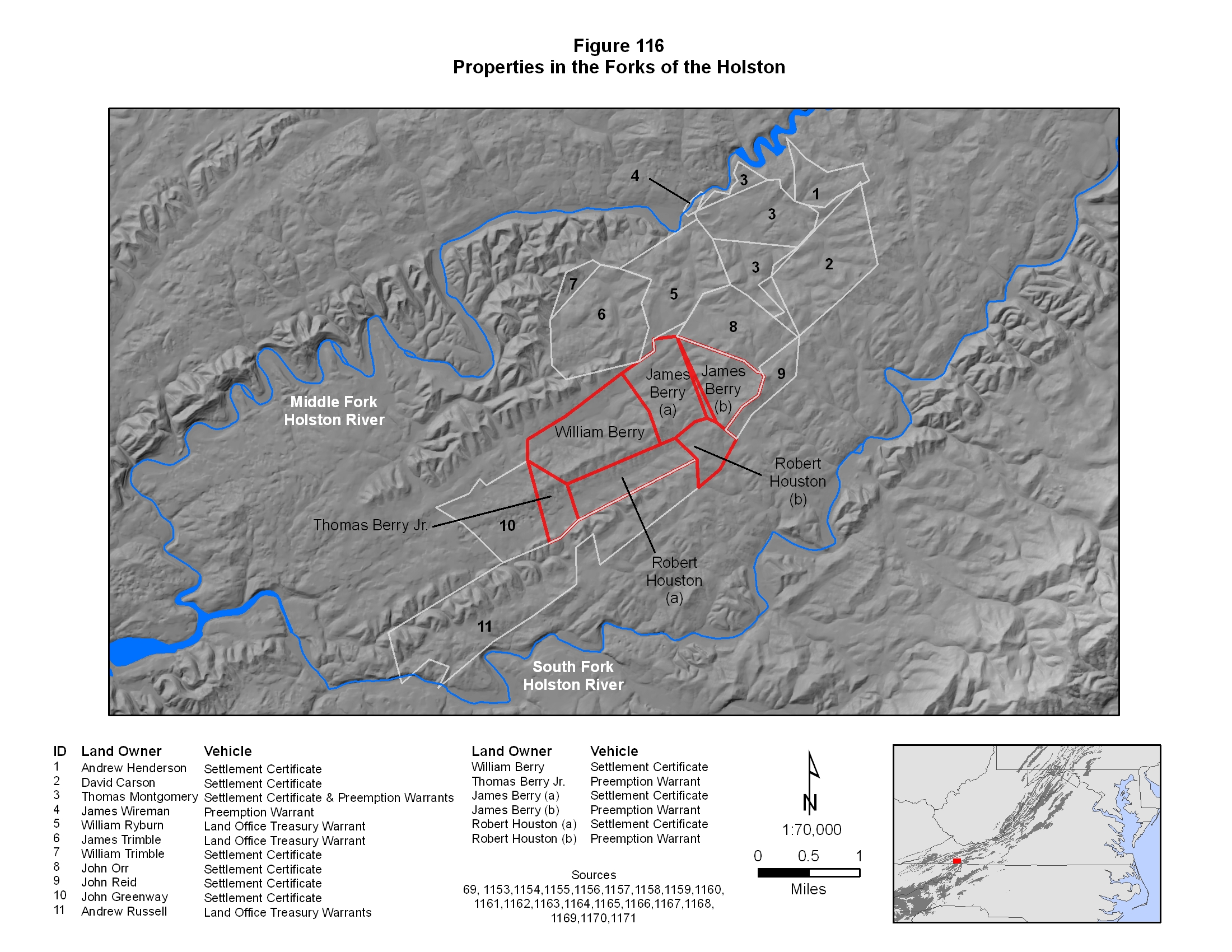
William Berry's Property
|
When the tithable district boundaries are combined with tithable list membership, then early Botetourt County tithable records can be utilized to ascertain which part of the Holston valley William Berry lived in at a certain time, and a fairly accurate determination of the timing of his arrival in the area can be made. Furthermore, Washington County land survey records can be used to provide additional clarity. While the 1770 tithable list records for Anthony Bledsoe’s Lower Holston Valley District are missing, Robert Doak’s list for the Upper Holston Valley has survived, and there are no entries for a William Berry, which probably means he had not yet arrived in the area. The 1771 tithable lists for Captain Campbell, Captain Bledsoe and Robert Doak have survived, and the absence of William Berry in any of these extant lists, which cover both the Upper and Lower Holston Districts, also suggest that William Berry was not yet living in southwestern Virginia. Washington County land survey records, on the other hand, show that William Berry staked out 400 acres of land sometime in 1771 on the Middle Fork of the Holston not far from the confluence of the Middle and South Forks, which is well within the boundaries of the Lower Holston Valley tithable district. From this data it can be concluded that, while William Berry was definitely in the area marking his territory, he was not yet living there.
|
|
The 1772 tithable lists for both tithable districts of the Holston Valley are covered by lists from Captains Looney, Bledsoe and Campbell, and two individuals named William Berry, as well as a James Berry appear in Captain Campbell’s militia list of the Upper Holston Valley District in that year. Since William Berry originated in Augusta County, staked out his property in the Lower Holston district in 1771, was recorded as living in the Upper Holston District in 1772, and soon settled permanently near the rest of the Berry cluster of settlements in the Lower Holston district, his appearance in the 1772 tithables record, in a location between his starting and ending points, strongly indicates that his first arrival in the area was in 1772, and that he probably used that area as a home base before making his final move to the land that he had selected in 1771. Apparently, William Berry made a stop on his journey from Augusta County, and remained in the upper Holston district long enough to be enumerated during the annual generation of the tithable list for the district. Sometime during his stay in the upper Holston Valley District he must have traveled into the Lower Holston Valley District to locate, mark and execute all of the legal settlement requirements for ownership of the land that he selected.
|
|
Of particular interest is the fine difference of meaning in the term “settlement”. The land survey data for the property that William Berry eventually owned shows that in 1771 he made the necessary improvements to meet the settlement requirements for his property on the Middle Fork of the Holston located within the Lower Holston Valley Tithable District. The tithable data, however, indicates that he was not actually living in that area yet, despite the fact that he met the “settlement requirements”. This clearly underscores the significant differences in the meaning of the term “settlement” - one being the meeting of a legal requirement and the other indicating an actual place of residence. To deal with the flood of settlers streaming into southwestern Virginia and squatting on any lands of their own choosing, the Virginia General Assembly in Williamsburg, the colonial capital of Virginia, developed a land patenting process that sanctioned land ownership for the many families who were claiming what they perceived to be open lands. Squatters who could prove that they had made an improvement and planted a crop on or before a certain date were classified as having settled the land and were allowed to purchase 400 acres around their “settlement” site by means of a Certificate of Settlement, which merely required marking the land and growing a crop, which could easily be accomplished on an exploration trip through the area. In addition, through what was called a Preemption Warrant, they were also entitled to an additional 1,000 acres of adjoining land, if it was available. In this case, William Berry clearly lived at a different location at the time that he selected his land and made his improvements. If he had actually been living in the area at the time, he would have been recorded in the head count tallies of the Lower Holston Valley tithable lists.69,968,976,991,997
|
|
Another critical source of information on William Berry and the other two Berry men he was associated with in the early 1770s is the Cummings Petition. In late 1772 and early 1773 a group of Presbyterian settlers in southwestern Virginia, most likely all of them being Scotch-Irish in ethnic origin, submitted a petition to church leaders back in Augusta County, where most of these settlers had recently emigrated from, requesting the services of a local Presbyterian minister, Charles Cummings. Among the 135 signers of the petition were two William Berrys and a James Berry, presumably the same men who were enumerated in Captain Campbell’s tithable list in 1772. Their presence on this list further fixes their location in the Holston Valley in late 1772 and early 1773. By this time, though, the county boundaries had changed again, and the area fell within Fincastle County. Most likely, all three of them were squatting on Virginia land, although the land records indicate that all of them had fulfilled their settlement requirements for selected tracts of land in the vicinity of the confluence of the Middle and South Forks of the Holston River, which is located well within the Lower Holston Valley Tithable District.69
|
|
A comparison of the Cummings Petition with the other population data sets covering the area, the Botetourt tithable records from 1770, 1771 and 1772, the 1774 Fincastle militia listings, and the Washington County Survey Records, reveals some interesting information about the timing of the migration of the settlers into the area, the general location of their homesteads and the areal distribution of the people who signed the petition. The bulk of the Cummings petition signers also appear in these other population data sets. A small number of the Cummings Petition were from the Upper Holston District, but, by far, the bulk of them were from the Lower Holston District, although there is a small group who can be identified as eventually living in the Clinch River valley. Being a wide expanse of farmable land between the fold belt mountainous uplifts of the Appalachian Mountains, the Holston valley was the first to be encountered by settlers traveling along this migration pathway from the Virginia settlements farther north. It was the most densely settled region, mostly because it was quite large and right along the main movement corridor. The North Fork of the Holston and the Clinch valleys were off the main migration pathway and much smaller, and so could not accommodate as many settlers as the much larger valley of the Middle and South forks of the Holston River. Other than the isolated hunting cabins of the occasional Long Hunter, the Holston valley was being settled as early as 1769 by farmers, with the bulk of the influx arriving in the early part of the 1770s, which is right when William Berry arrived. While a few settlers ventured into the Clinch valley, that area wasn’t seriously settled until around 1772, 1773 and 1774. Even then, it did not receive the volume of settlers that had moved into the Holston valley. The Holston valley, therefore, was the prime target for the bulk of the settlers who arrived in southwestern Virginia. |
Multiple William Berrys
|
Two individuals named William Berry appear in these early Botetourt County data sets. One of two William Berrys found in Captain Campbell’s 1772 tithable list is identified as William Berry, while the other is identified as William Berry, Jr. While the “junior” moniker certainly could mean that William Berry Junior had a father named William Berry, it could also refer to the fact that the William Berry identified as junior was merely the younger of these two individuals with the same name. The latter is the most likely scenario, since the use of the junior designation was a common practice of county clerks during colonial times for differentiating between two individuals with the same name.
|
|
In an effort to identify these two William Berrys, it is important to understand various elements of the known Berry family presence in southwestern Virginia during this time. Assuming that both men originated from this Scotch-Irish Berry clan there are several candidates. The fact that only two William Berrys occur in any of these early Botetourt County records, particularly the Cummings Petition, strongly suggests that both William Berrys were Presbyterians, and thus of Scotch-Irish stock. Consequently, chances are quite strong that they were related to each other. At this early time period, the early 1770s, all individuals with the surname of Berry appearing in southwestern Virginia records have been attributed to this Scotch-Irish Berry lineage, so, based purely on this string of circumstantial evidence, both William Berrys certainly were probably members of this Berry clan.
|
|
Since this Augusta/Washington County Scotch-Irish Berry clan tended to use the same given names, multiple, related individuals with the same given name and surname are quite common, and numerous William Berrys can be positively identified in the various documented lineages. Of course, the same is also true for numerous Thomas, James and John Berrys. Table LVI provides a list of the known individuals named William Berry from this family group, as identified through the various elements of documentation in this Berry family report. When the individuals who are too young to have been the William Berrys represented in these records are eliminated, only four possibilities remain. One of these four William Berrys was a member of what is here referred to as the second generation of this Berry clan, and the rest are from the third generation. Of these four possibilities, however, none of them had a son named William Berry who was old enough to appear on a tithable list in 1772, which certainly seems to discount the theory that the William Berry and William Berry junior from the 1772 tithable list are father and son. The William Berry who born about 1720 is from the second generation and is known to have lived in Augusta County and Rockbridge County for his entire life, so he can be eliminated, leaving only the third generation William Berrys. From this list, the William Berry born in 1755 served in the Augusta County militia throughout the Revolutionary War. His life is well documented and he does not appear to have ever lived in Botetourt County. His elimination from consideration leaves only two possibilities from this Berry clan – one being a grandson of the elder John Berry and the other a grandson of the elder James Berry. The elder James Berry descendant, born about 1744, is a son of Thomas Berry Sr. (1718 – 1799) and the subject of this segment of the Berry report. The other, a descendant of the elder John Berry, was born about 1738, and is one of the mysterious orphans of James Berry (~1716 – 1749) as identified in the Augusta County court records from the early 1750s.
|
|
Unfortunately, at this point it is impossible to further differentiate these two individuals, but at least these two can be identified. The two William Berrys in the Botetourt County tithables could easily and most likely do represent both of these individuals. If the junior moniker merely denotes two same-named individuals of different ages, and not father and son, and these two individuals are from the same Berry clan (and thus related), as the Cummings Petition suggests, then it seems logical to assign these two tithable entries to these two William Berrys with the orphaned William Berry being the older of the two men. The correlation is strongly circumstantial rather than definitive, and given the absence of other evidence, seems to be the most logical assessment at the present time. An alternative theory is that one of the William Berrys was not a member of this Scotch-Irish Berry clan. |
Table LVI
William Berry Occurrences in the First Four Berry Generations
| Generation | Life Span | Candidate Status | Berry Lineage |
| I | |||
| II | (~1720 - 1791/1793) | possible | son of the elder John Berry |
| III | (1755 - 1838) | possible | grandson of the elder James Berry |
| III | (~1744 - 1781) | possible | grandson of the elder James Berry |
| III | (~1738 - ?) | possible | grandson of the elder John Berry |
| III | (1763 - 1842) | too young | grandson of the elder John Berry |
| IV | (1796 - 1850) | too young | great grandson of the elder James Berry |
| IV | (~1768 - after 1809) | too young | great grandson of the elder James Berry |
| IV | (~1767 - 1810) | too young | great grandson of the elder James Berry |
| IV | (1781 - ?) | too young | great grandson of the elder James Berry |
| IV | (1766 - 1850) | too young | great grandson of the elder John Berry |
| IV | (1765 - 1822) | too young | great grandson of the elder John Berry |
| IV | (1789 - 1864) | too young | great grandson of the elder John Berry |
|
William Berry was killed in action on the 6th of March 1781 while serving in the Virginia militia during the Revolutionary War. In early February of 1781, just prior to his deployment, he had made out his will, which was exhibited in Washington County court in mid June of 1781, just over three months after his death. In that will, William Berry left his Washington County property to his young son Thomas, who was about five years old at the time, and noted that his wife, Mary, would have the right to remain on the property for the rest of her natural life. He also noted the existence of, but failed to identify by name, his two daughters, and indicated that his wife was pregnant. Although he specifically identified Thomas Berry Sr., and James Berry, his father and brother, respectively, and named them as witnesses to his last will and testament, the family connections were not specified. James Berry also served as a testamentary in the recording of the document.
|
|
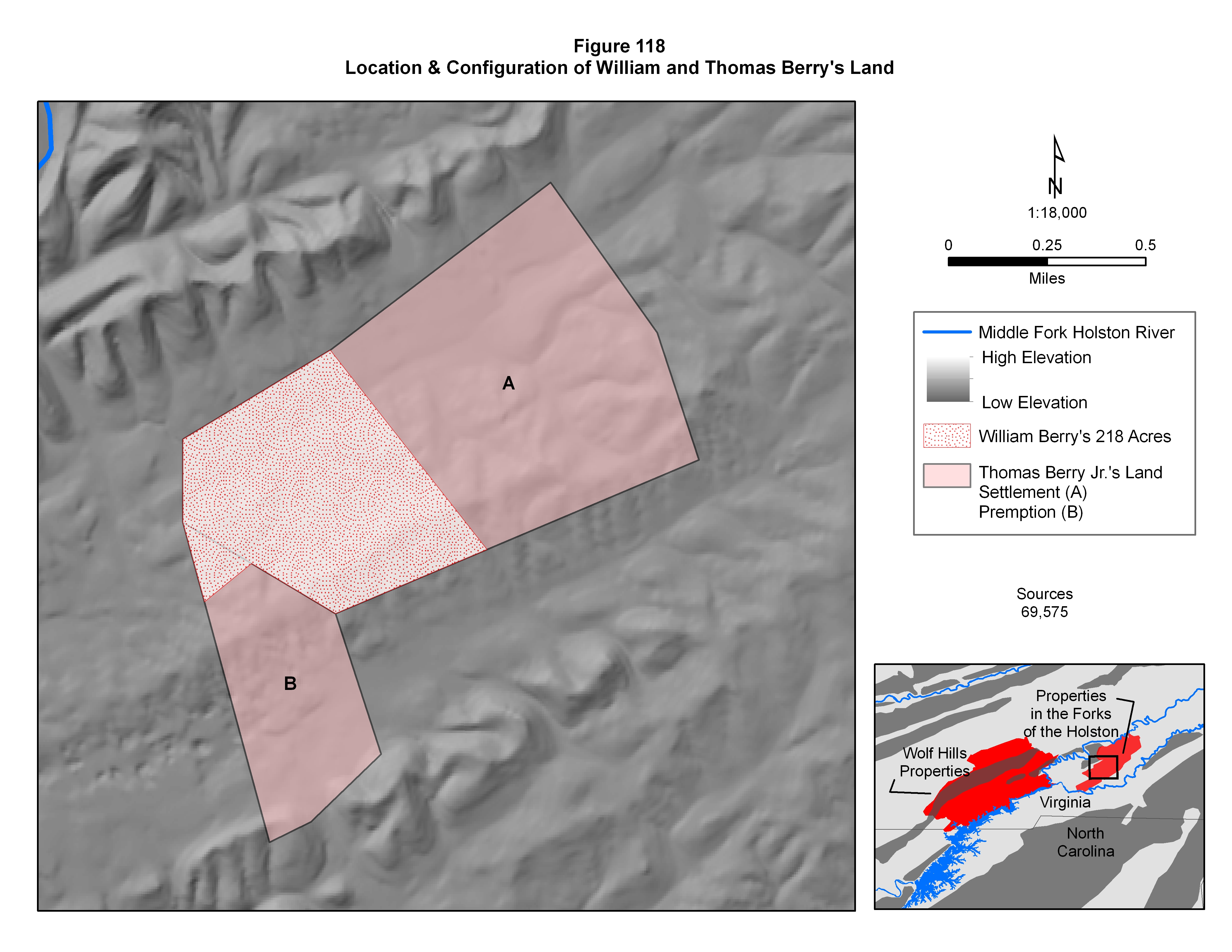
On the 30th of August 1781, 400 acres of land on a branch of the Middle Fork of the Holston River was surveyed for Thomas Berry Jr., who was identified as a legatee of the deceased William Berry. The grant was issued as a Settlement Certificate, which was predicated on the documented successful completion of the settlement requirements in 1771, obviously by the deceased William Berry prior to his death. By definition a legatee is a person who receives personal property through a will, so this document is conclusive proof that this acreage along a tributary of the Middle Fork of the Holston River was being passed down to Thomas Berry Jr. from his deceased father, William Berry. Quite clearly, then, this was the land that was being staked by William Berry back in 1771 when he first arrived in the area. About eight months later, in late 1781, an additional 134 acres was surveyed on land adjacent to the original settlement by virtue of a Preemption Warrant for the legatee, Thomas Berry Jr. By Virginia law, William Berry, and therefore his legatee, was entitled to an additional thousand acres adjacent to the original 400 acre claim, although, as documented here, a lesser acreage was actually purchased. Reference to Figure 116 shows that much of the adjacent farmable land had already been claimed, so one thousand contiguous acres of farmable land was not available. Since Thomas Berry Jr. was only five or six years old at the time, it is quite clear that he was a minor living with his mother, Mary Berry, who was the actual head of the household, the latter being firmly documented not only through Washington County tax records from 1782 through 1801, which describe her as the head of household, but also through the land descriptions of the adjacent property owners. The property of the deceased William Berry was adjacent to that of James Berry and Robert Houston, both, of whom were also listed on Captain Campbell’s militia company in Robert Doak’s 1772 Botetourt County tithable list, which confirms their presence in the area at the time all of them were staking out their property claims. In addition, the property descriptions for both James Berry and Robert Houston show that they shared a property boundary with Mary Berry. A comparison of the surveyor’s land descriptions demonstrates that the shared boundaries exactly correspond to the land technically owned by Thomas Berry, legatee of William Berry, which firmly connects Thomas Berry as being the son of a deceased William Berry and the widow Mary Berry. Firmly supporting the Berry family connection to this property ownership is the 1799 will of William Berry’s father, Thomas Berry, Sr., in which he notes that his son William had passed away and that the name of William’s widow was Mary.56,120,491
|
|
Consequently, through the combination of tithable, land survey, court and tax records it can clearly be demonstrated that one of the William Berrys in the early Botetourt County records represents a son of Thomas Berry, Sr. The remaining question, however, is the identity of the other William Berry. The latter man apparently purchased rights to some land not far from William Berry, on the other side of the river along the South Fork of the Holston River, but later sold his interest to another Berry family member - John Berry, who was one of the Augusta County orphans from the early 1750s. As outlined in Table LVII, this land parcel, in fact, was originally “settled” by John Harris, who sold out to William Berry, who, in turn, transferred ownership to John Berry. The original settlement date was listed as being in 1770, which is, clearly, a result of the actions of John Harris, who acquired the original rights to the land rather than any of the subsequent owners. John Harris appears in Robert Doak’s 1771 tithable list, confirming his presence within the Lower Holston district, and that is exactly the location of the property that ultimately came to be owned by John Berry. Based on this land history and association, and, in particular, the intimate association with the Cummins Petition, it appears that the William Berry who originally purchased the rights to the land could have been John Berry’s brother, and, therefore, one of the Augusta County Berry orphans.69,843 |
Table LVII
Land Acquisitions in the Lower Holston Valley by William & James Berry
|
Name |
Acres |
Settlement Date |
Watercourse |
|
James Berry |
400 |
1771 |
Middle Fork of Holston |
|
William Berry |
400 |
1771 |
Middle Fork of Holston |
|
John Berry assignee of William Berry assignee of John Harris |
400 |
1770 |
near confluence of Middle and South Forks of the Holston |
|
One more subject that needs to be covered is the relationship between William and James Berry. Analysis of Botetourt County Tithable records, the Cummings Petition, Washington County survey records, the Fincastle and Washington County court records and a federal pension application reveals a curious geographic association between one of the William Berrys, presumably the above identified son of Thomas Berry Sr., and a James Berry from 1772 through 1781, faintly suggestive of some kind of kinship. Since only one individual named James Berry appears in these records, thus eliminating the necessity of differentiating between same-named individuals, and information on the structure of Thomas Berry Sr.’s family clearly demonstrates that he had sons named James and William, the possibilities are narrowed down enough to support an interpretation that James Berry was a brother of one of the William Berrys that appears in these records.12,410,545,596,685
|
|
In the Botetourt County tithable records, only one individual by the name of James Berry appears in any of the Holston Valley tithable districts, and that would be the 1772 list of Captain Campbell’s militia company in the upper Holston valley. Likewise, only one James Berry is listed in the Cummings Petition, which strongly associates James Berry with a Scotch-Irish ancestry. The names of William and James Berry are found in each of these data sets. Survey records from Washington County clearly show that both William and James Berry completed the legal requirements for settlement on lands located along the Middle Fork of the Holston River in the Lower Holston Valley tithable district. In fact, these records further confirm that they established their claims the same year and on adjacent plots of land. Both men can also be traced through appearances in Washington County court records when they served on juries. In his application for a federal pension, Thomas McSpadden noted that he had served in the same company as both William and James Berry on different occasions, which, if nothing else, strongly suggests that they lived fairly close to each other. Perhaps the strongest correlation of James Berry to William Berry comprises the will and subsequent court records related to the distribution of William Berry’s estate. William named his brother and his father as the executors of his estate, an assignment one would expect to be given to a close family member.
|
|
In summary, it appears that these two sons of Thomas Berry, Sr. left their boyhood home in Augusta County in the early 1770s and followed both their father and the tide of settlers streaming into southwestern Virginia. They established a temporary living space somewhere in the upper Holston Valley while they scouted the area farther south in the vicinity of modern day Abingdon for settlement sites. Their brother Thomas Berry and their father, Thomas Berry Sr. also scouted for land in the area at the same time, so it seems very likely that there was some coordination in their efforts. William and James settled on land near the mouth of the Middle Fork of the Holston, and soon became involved in local government and, in all likelihood, were members of the local militia during times of emergency. |
Back to the Timeline
|
With an estimated marriage date of 1773 or 1774, William Berry was probably still single and could even have been living in his parents’ household at the time the family moved to the Holston Valley from their home in Augusta County. Since the entire area came under the jurisdiction of Fincastle County in early 1773, it can be safely assessed that his marriage took place in Fincastle County, Virginia. The identity of his wife is not known with certainty, other than her first name, which was Mary. There is, however, an abundant body of secondary sources assigning a surname of McSpadden to her, although without documentation. The closest connection, which is tenuous at best, is the fact that Thomas McSpadden served in the Virginia militia with William Berry and was with him when he was killed. Since he made a special mention in his 1832 pension application about William Berry’s death in a skirmish at Whitsell’s Mill in North Carolina, it has appeared to some researchers to represent the concern of a family member. According to this interpretation, then, Thomas McSpadden would have been Mary McSpadden’s brother. While this interpretation may very well be true, there is absolutely no documentary evidence to support it. Unfortunately, without the necessary evidence, the interpretation must be considered only as circumstantial evidence, so her surname must be stated as being unknown, but possibly McSpadden, albeit unproven.1136,1137,1138,1139,1140
|
|
William and Mary’s first child, a son they named Thomas Berry, most likely after William’s father, was born about 1775 in Fincastle County, Virginia. Between 1776 and 1778 two more daughters were born, but by that time, the area where they lived had been reorganized again and now fell within the boundaries of Washington County. Their last child, William Berry was born a few months after William’s death. William Berry appears in several Washington County court records, serving jury duty in 1778 and 1780, with the last occurrence being in late November of that year. In early February his militia unit must have been called up because he made out his last will and testament just before being deployed.
|
|
While there is no documentation, in all likelihood, William Berry participated in some of the military campaigns that affected the frontier settlements of North Carolina and Virginia during the Revolutionary War. Extensive documentation of the participants in the Battle of Point Pleasant which took place in the fall of 1774 indicate that William Berry definitely did not serve in any of the militia units involved in that battle, but he certainly could have served in Battle of Long Island Flats in the summer of 1776, the subsequent punitive campaign against the Cherokee tribes led by Col. Christian later that year, and other militia deployments against the Cherokee and Shawnee and the King’s Mountain battle in the fall of 1780. The only definitive information about his military service comes from a Revolutionary War pension application made by a fellow soldier, Thomas McSpadden, who served in the same militia company as William in early 1781. In the application Thomas McSpadden noted that his militia company, under the overall command of Col. Campbell and the same unit he had served with in the King’s Mountain Campaign where he served with William’s brother James Berry (although the relationship between William and James was not stated), was called up again a few months later in the spring of 1781. By that time the company was led by Captain James Montgomery, replacing Capt. Edmondson who had been killed the previous fall at the King’s Mountain battle. Since Thomas McSpadden had served in the same company in the fall of 1780 and William Berry was a member of his 1781 company a few months later, it seems logical to presume that William Berry could also have served in the King’s Mountain battle the previous fall. Unfortuantely, there is no documentation to support this theory. In his pension statement Thomas McSpadden noted that the company was involved in a skirmish at Whitsell’s Mill on the Haw River in North Carolina, while pursuing General Cornwallis’ troops, and William Berry was killed as the men retreated in the face of superior firepower. |
War in the Carolinas
Events Leading up to the Deadly Skirmish at Whitsell's Mill
|
After an initial unsuccessful British assault on the southern American colonies in 1776, British forces withdrew, temporarily abandoning the southern campaign for the next few years. In February of 1780, however, they returned, capturing Charleston, South Carolina. They quickly expanding inland to occupy the backcountry of South Carolina and Georgia, overrunning the towns of Camden, Ninety Six and Augusta by the end of June 1780, where they established forward operating bases and supply depots. In the middle of August, a Patriot army made up of militia and regular forces (continentals) was soundly defeated at Camden (partially because the militia turned and ran when confronted), making it appear that the British now had firm control of the south. Patriot soldiers who surrendered or captured at Camden were executed, generating a great deal of resentment on the part of the Americans, and probably providing a great motivating force for subsequent atrocities committed by Patriot forces. In a series of battles that followed, the tide of the southern campaign, and the course of the war itself, was completely reversed. First, Patriot militia, mostly from North Carolina and Virginia, soundly defeated the British-run Loyalist militia at the Battle of King's Mountain in early October 1780. After that, General Nathaniel Greene was placed in command of all Patriot forces in the southern colonies. The American forces were not strong enough to directly face the British, nor was there enough food and supplies to concentrate them, so he divided his outnumbered army, sending half with Brigadier General Daniel Morgan, and dispersing them into small units operating throughout the South Carolina back country, quite often terrorizing and plundering Loyalists in the process of supplying themselves in their foraging activities. The militia forces acted as a protective layer between the main British and American forces, while hampering communications and supply lines. Supplies could easily reach the Americans by being floated downstream, but British supplies had to move upriver or along roads, both, of which, were easily subject to guerilla actions. As the Patriot military threat grew, General Cornwallis, the overall British commander, feared an attack against his supply outpost at the town of Ninety Six, so he sent his fast-moving light troops under the command of Lieutenant Colonel Banastre Tarleton in search of Morgan. (Figure 62)786,787,788,789
|
|
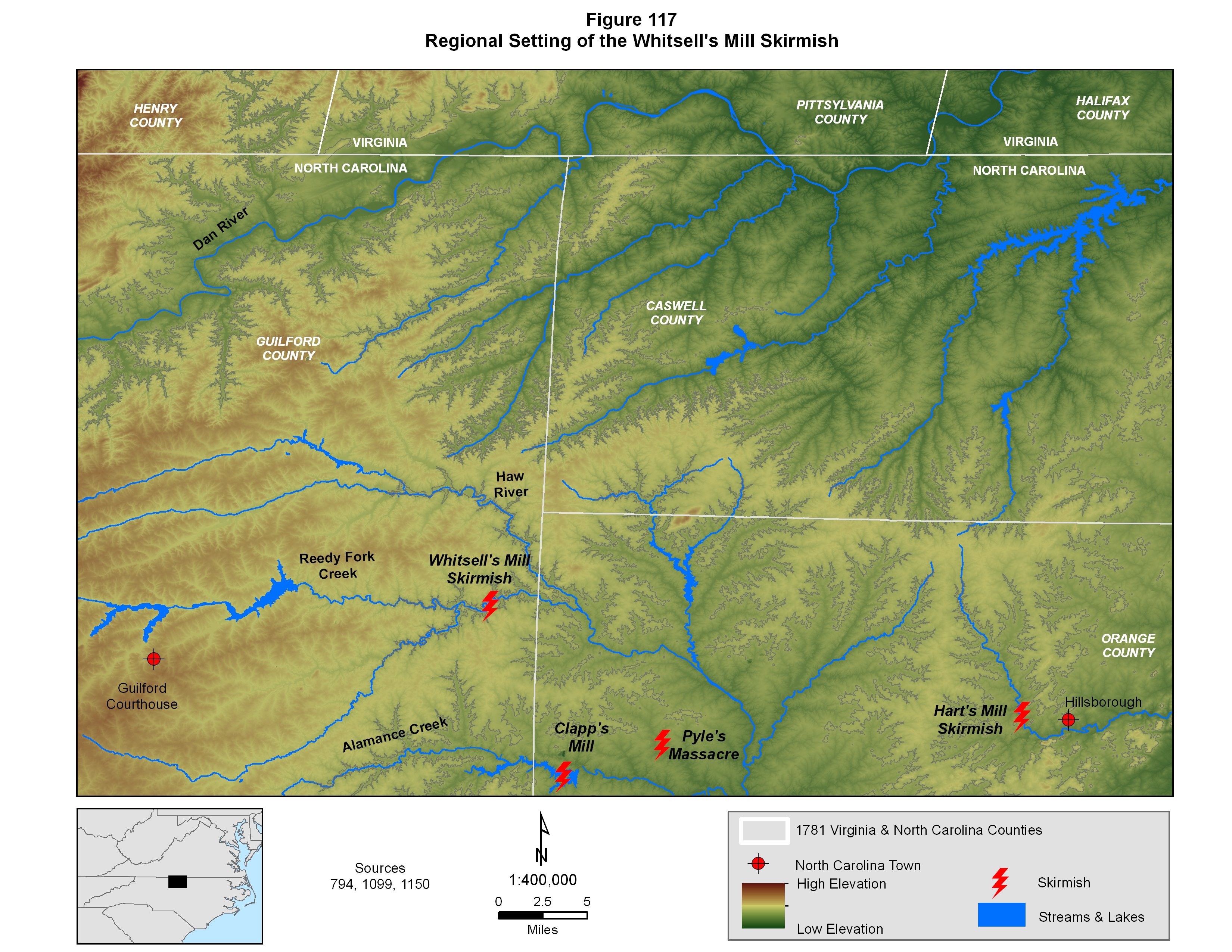
The resulting Battle of Cowpens, a significant victory by the Americans over the British, was fought in northwestern South Carolina on 17 January 1781. After the battle, General Greene, the commander of the American forces opted to quickly withdraw to wait for reinforcements, protect his army from destruction and resupply so he could continue the resistance effort. To that end he quickly moved his troops northward to the relative safety of Virginia in what soon became known as the “race for the Dan”. The Dan River formed the boundary between North Carolina and Virginia in this area, and it was running high. Cornwallis seized the fords in the upper part of the river, and seemed to have cut off Greene and his entire army, but, anticipating this, Greene had previously requisitioned all of the boats throughout the region and placed them downstream. Based on this military foresight, he was able to safely move his army out of harm’s way and put the swollen river between him and Cornwallis’ menacing army. For the next several weeks Greene kept Cornwallis at arms length by a series of skirmishes and raids while receiving a steady stream of reinforcements. This tactic allowed him to avoid a general engagement until he was sufficiently reinforced and resupplied to the point where he could directly challenge the British army. By early March, enough Continental troops and Virginia and North Carolina militia units had arrived that Greene felt he was strong enough to go on the offensive. With his army now numbering just over 4,000 strong, more than double the size of Cornwallis’ command, he recrossed the Dan River and chose the ground upon which to openly present a challenge. The battleground he selected was an isolated backwoods town called Guilford Courthouse, in the middle of modern day Greensborough, North Carolina, and by 11 March, his troops were in place. Unfortunately, by that time, William Berry of Washington County had been killed in one of the skirmishes leading up to that engagement. (Figure 117)786,787,788,789
|
|
As he was in the process of conducting a strategic withdrawal toward the Dan River, General Greene urgently called for reinforcements, and, immediately upon receiving the order from Virginia Governor Thomas Jefferson, Col. Arthur Campbell, the Washington County Lieutenant, ordered new militia call-ups. Virginia Governor Thomas Jefferson’s militia draft order called for riflemen from Washington, Montgomery and Bedford Counties and over a thousand men from various Virginia counties east of the mountains. Very soon afterwards, a considerable number of short term militia units began flooding into General Greene’s camps in south central Virginia to oppose Cornwallis’ advance. Obviously receiving intelligence on this military buildup, Cornwallis retreated a safe distance from the Dan River where he could safely resupply his troops and gather Loyalist reinforcements to bolster his ranks. The Washington County militia company to which William Berry and Thomas McSpadden belonged was drafted in early February and was clearly part of General Greene’s reinforcement effort. As William Berry wrote his will in the basin of the Middle Fork of the Holston River back in Washington County on the fifth of February, the desperate “Race to the Dan” was underway nearly 200 miles to the east. Several weeks later, on the 25th of February, 100 recruits from Washington County under the command of Col. William Campbell marched out of Abingdon, arriving on the second of March to join hundreds of other citizen soldiers swelling the ranks of Greene’s army.1142,1144,1149
|
|
On the 21st of February Cornwallis established his headquarters in Hillsborough, North Carolina, and within a day, North Carolina militia units fought a skirmish at Hart’s Mill, just outside of that town. This engagement was, essentially, the beginning of Green’s offensive campaign against Cornwallis’ army. Several days later, on February 24th, Lt. Col. Light Horse Harry Lee’s unit of Virginia Continental cavalry, Maryland infantry and South Carolina militia crossed the Dan River to monitor British activity. By the end of the day, near modern day Burlington, North Carolina, in an encounter referred to as Pyle’s Massacre, they soundly defeated a large group of Loyalists who were responding to Cornwallis’ call for volunteers. Virginia militia elements do not appear to have been involved in either of these skirmishes, and William Berry’s unit was not yet in the field. On the 28th the British Army moved out of Hillsborough to a point just south of Clapp’s Mill on Alamance Creek, and the next day, March 1st, after receiving intelligence on Cornwallis’ movements, General Greene brought his now numerically superior army forward to draw Cornwallis into a major, decisive engagement. The plan called for Lt. Col. Light Horse Harry Lee to lead an assault on the British camp near Clapp’s Mill, then fall back under fire to a second line where continental and militia units waited in ambush. Unfortunately, the militia elements in the initial assault, mostly from Botetourt County, broke and ran under the heavy fire. Choosing not to pursue, the British withdrew in order, but not before suffering about twenty casualties. William Berry’s company was not involved in this skirmish either, since they had not yet arrived, but they would arrive soon and were immediately deployed into a forward position. (Figure 117)1141,1142,1143,1144,1145,1146
|
|
As soon as William Berry’s unit arrived, General Greene ordered his second in command, Col. Otho Williams, to take seven hundred men, which included William Berry’s newly arrived Washington County company of infantry riflemen, on a reconnaissance mission to keep tabs on Cornwallis’ position. The American force then ventured into the dangerous territory between the two armies. On the 4th of March Cornwallis received intelligence that Col. William’s force was encamped on the South side of Reedy Fork Creek and isolated from Greene’s main army by the creek, so Cornwallis ordered Col. Banastre Tarleton to lead a force of approximately one thousand infantry and cavalry to destroy the American force. On the morning of 6 March 1781, under the cover of a thick fog, the British crossed the Alamance River and headed northward toward Reedy Fork Creek. Around 8 am, as they approached the road to Whitsell’s/Weitzel’s Mill, the British force was discovered by mounted patrols, and Lt. Col. Light Horse Harry Lee’s cavalry directly challenged them as the main body of the American militia along with their horses, baggage, supply and ammunition wagons were hastily withdrawn to safety on the north side of Reedy Creek. Once in place they drew up into a defensive line. Their mission was not only to move their camp and gear out of harm’s way, but also to gather as much flour and meal from the mill as possible to feed their own soldiers, and, of equal importance, to prevent these food supplies from falling into British hands. Along with the cavalry, one hundred and fifty Virginia militia riflemen were left on the south side of the creek to cover the movement and delay British forces. Without a doubt, William Berry was among the group of soldiers executing this delaying action. The American forces made contact with the lead elements of the British force and gradually withdrew in a leap frog manner, keeping up a constant fire against the pressing British forces steadily advancing toward the creek. British troops kept driving forward and soon overran the original camp on the south side of the creek, which clearly indicates that the Americans had left in a hurry and were not able to retrieve all of their equipment. The defensive line of riflemen on the north side of the creek provided heavy covering fire as the militia units withdrew across the creek and eventually joined the main body of troops. Eventually, though, the British brought up several artillery pieces, and since the American force had no artillery, in the face of superior fire, they were finally forced to withdraw toward the main army. The British were able to cross the creek and make their way up hill, but they eventually broke off without offering a serious pursuit, which ended the engagement. While the British lost around thirty killed or wounded, the American side suffered eight killed and twelve wounded, one of those killed in action being William Berry. It is not known exactly where William Berry fell - in the delaying action on the south side of the creek or on the north side, but it IS known that the practice of Cornwallis’ troops was to bury their own dead from such engagements, and to leave the bodies of killed Americans un-interred. Consequently, either William Berry was buried near the American camp when Col. Williams force made it back to Greene’s main army, or he was not buried at all. Either way, William Berry heroically gave up his life for his country on the 6th of March 1781, about two hundred miles from home. Col. Williams rejoined Green’s main army, now preparing for the pivotal battle of this campaign, the Battle of Guilford Courthouse, which took place nine days later.1147,1148,1149 |
Estate Appraisal and Tax Records
|
In mid August of 1783, about a year and a half after his death, William Berry’s estate was appraised at just over £2300 as shown in Table LVIII The bulk of the value of his estate lay in money that was owed the estate, with just over a thousand pounds from a posted bond and an additional thousand from what appears to be money owed to William from an unnamed source. The rest can be divided into three broad categories: livestock, household items and miscellaneous. By far, the most valuable element of the remaining estate lay in the livestock, which consisted of cattle and some horses and sheep, clearly defining an agrarian lifestyle. Some kitchen and bedroom furniture constituted the household items, none, of which, was particularly valuable. William Berry died quite young, before he had a chance to do much with his life, and the materials in his estate clearly show him to have been a farmer. |
Table LVIII
William Berry's Estate Appraisal
|
Livestock |
Value |
Household Items |
Value |
Misc. |
Value |
|
4 ewes |
0.10/2 |
trunk |
0.12 |
weaving cloths |
£5 |
|
2 wethers |
0.12/4 |
small trunk |
0.5 |
bible & religious books |
0.18 |
|
lambs |
0.6 |
feather bed & bedding |
£7.12 |
bonds |
£1197.7 |
|
? |
0.1 |
bedstead |
£2.36 |
book due |
£1000 |
|
cows |
£2.13 |
bed tick & bedding |
0.5 |
sales due |
£3.10 |
|
cows |
£3.10 |
? |
0.5 |
saddle |
0.2 |
|
brindle heifer |
£2.15 |
pewter dishes |
0.85 |
|
|
|
heifer |
£2.7.6 |
pewter dishes |
0.9 |
|
|
|
steer |
0.52 |
plates |
0.16 |
|
|
|
yearling |
£1.5 |
basin |
0.4 |
|
|
|
yearling heifer |
?? |
basin |
0.6 |
|
|
|
yearling heifer |
0.15 |
basin |
0.7 |
|
|
|
yearling heifer |
£2 |
pot |
0.12 |
|
|
|
cow |
£3 |
pot |
0.1 |
|
|
|
cow |
£3.10 |
dutch oven |
0.8 |
|
|
|
cow |
£3 |
large pail |
0.1 |
|
|
|
calves |
£1.10 |
large pail |
0.1 |
|
|
|
cow & calf |
£3.10 |
dresser furniture |
0.11 |
|
|
|
cow & calf |
£3 |
table |
0.12/6 |
|
|
|
white mare |
£25 |
|
|
|
|
|
horse |
£9 |
|
|
|
|
|
chestnut mare |
£15 |
|
|
|
|
|
year old filly |
£10 |
|
|
|
|
|
mare & colt |
£20 |
|
|
|
|
|
In addition to the revitalization of the Land Office, the Virginia revenue office was also reinvigorated after the war. Personal property taxes began to be regularly collected and Mary Berry, William’s widow, first appears on the rolls in 1782, as did nearly everyone else in the county. The few occurrences of women in these early tax records nearly always identify widowed heads of household who had not remarried, which was clearly the case with Mary Berry. She was usually listed as a widow in the tax records. There are no males old enough to be taxed in her household during the 1780s, since they were still quite young, but she was taxed on some cattle and horses, which not only strongly underlines the agrarian nature of her life, but also reconfirms the evidence provided by her deceased husband’s estate. In fact as long as she was recorded in the tax records, she was listed as owning taxable livestock. From 1782 through 1799 Mary Berry was listed as the head of her household in these tax records. Beginning in 1791 her oldest son Thomas began appearing as a male between the ages of 16 and 21, and finally in 1800, just after he reached the age of about 22, he began appearing independently. For several years after Thomas “left” the household, his younger brother William appeared in his mother’s household as the underage male. Beginning in 1802, though, Mary was no longer listed as the head of the household. Instead, her youngest son William filled that role. (Table LVIV) Mary Berry must have continued living there, since the 1810 federal census lists her as the household head in the house along with a male born sometime between 1765 and 1784. Since her youngest son, William, was born in 1781 he definitely fits into this age category. In the 1781 will of Mary’s husband, William Senior had stated that his wife/widow would have the right to live out her life on the original property, and the combination of Washington County tax records and federal census records clearly documents this is exactly what happened.
|
|
William Berry (son of William who died in 1781) was listed in the tax records with the descriptor of “forks”, indicating that there were two William Berrys in the tax district, and this one lived near a river fork. In this case, the forks designation clearly refers to the point where the Middle Fork of the Holston River merges with the South Fork. In the federal census records, as well as in the county tax records, Thomas Berry is listed next to Mary Berry. This strongly suggests that these Berry households remained neighbors, most likely adjacent neighbors, for years. So, Mary Berry, in her old age, lived with her youngest son William and next door to her oldest son, Thomas. Unfortunately, the identity and location of her daughters is not known. The date and location of Mary’s death is not known at all either. She does not appear to have remarried after her husband’s untimely death, and lived her remaining years either with her son, William, or with one or more of her daughters. William Berry continued to be recorded in the Washington County tax records until 1816, when he sold his property and moved elsewhere. No definitive trace and no descendants from her daughters have yet been identified. |
Table LVIV
Washington County Personal Property Tax Records for the Survivors of William Berry
|
Year |
White Tithables |
Underage Males |
Taxee |
|
1782 |
|
|
Mary Berry |
|
1783 |
0 |
|
Mary Berry |
|
1784 |
0 |
|
Mary Berry |
|
1785 |
ND |
|
|
|
1786 |
ND |
|
|
|
1787 |
0 |
|
Mary Berry |
|
1788 |
0 |
|
Mary Berry |
|
1789 |
0 |
|
Mary Berry |
|
1790 |
0 |
|
Mary Berry |
|
1791 |
1 male 16 - 21 |
Thomas |
Mary Berry |
|
1792 |
|
|
Mary Berry |
|
1793 |
1 male 16 - 21 |
Thomas |
Mary Berry |
|
1794 |
1 male 16 - 21 |
Thomas |
Mary Berry |
|
1795 |
1 male 16 - 21 |
Thomas |
Mary Berry |
|
1796 |
ND |
|
|
|
1797 |
1 male 16 - 21 |
Thomas |
Mary Berry |
|
1798 |
1 male 16 - 21 |
Thomas |
Mary Berry |
|
1799 |
0 |
William |
Mary Berry & son |
|
1800 |
ND |
|
|
|
1801 |
2 |
William, ? |
Mary Berry |
|
1802 |
ND |
|
|
|
1803 |
ND |
|
|
|
1804 |
1 |
|
William Berry (forks) |
|
1805 |
1 |
|
William Berry (forks) |
|
1806 |
1 |
|
William Berry (forks) |
|
1807 |
1 |
|
William Berry (forks) |
|
1808 |
ND |
|
|
|
1809 |
1 |
|
William Berry (forks) |
|
1810 |
1 |
|
William Berry (forks) |
|
One more note of interest is the relative property locations for William and Mary Berry’s sons, Thomas and William. The importance of the geographic specificity for these land parcels is reflected in the fact that during part of her golden years, Mary Berry lived with her son William Berry and adjacent to her son Thomas, but, up to this point, William’s property has not been defined. In late March of 1802, Thomas Berry, who had inherited all of his property from his father, sold part of it to his brother William, whose “share” constituted the western half of their father’s original 400 acre settlement plus a small portion of the preemption, as shown in Figure 118. The 1810 federal census enumeration clearly demonstrates that, while Mary Berry, William Berry’s widow, permanently disappeared from Washington County tax records about the time of this land sale in 1802, she was still living in the same space at least until 1810. Her youngest son, William, had grown up, and, after his land purchase, became the official head of household, which included his mother. Prior to 1802, that situation was reversed. Another intriguing possibility is that the original cabin, the family home that was probably built by the elder William Berry, could easily have been located on the chunk of land William Berry acquired, and could have been where Mary spent her final years. |
![]()
Figures,
Tables and Bibliography
Search
This Site
![]()
|
|
|
These electronic pages may NOT be reproduced in any format for profit or presentation by any other organization or persons. Persons or organizations desiring to use this material must obtain the written consent of the contributors, or the legal representative of the submitters |
Last Revised: 11/06/2013