![]()
Hugh Campbell and Esther MaGill
![]()
![]()
B.1.c. John Berry
|
John Berry was born in 1743 as indirectly documented by Augusta County, Virginia court records related to the determination of John’s legal guardianship after his father’s death. His place of birth is uncertain, as well, but is most likely either Lancaster County, Pennsylvania or Augusta County, Virginia. The reason for the uncertainty is the lack of documentation for this early stage in John Berry’s life, and the existence of a smattering of information on the whereabouts of his maternal grandfather, William MaGill. The marriage of John’s father (James Berry) and his uncle (William Berry) to two daughters of William MaGill (Jane and Elizabeth), as well as John Berry’s eventual marriage to Jane Campbell, a daughter of Hugh Campbell and Esther MaGill, the latter being a sister of both Jane and Elizabeth MaGill, highlights a fairly close relationship between these Scotch-Irish families, the Berrys and MaGills. Consequently, knowing the location of the MaGill family prior to their move to Augusta County, Virginia, and approximating the timing of their move to Virginia most likely defines the location of the Berry family, which allows an assessment of the place of John Berry’s birth, but therein lies a thorny and complicated issue.21,204,205,206,208
|
|
As noted in William Magill’s biographic essay, he was born in either Scotland or northern Ireland, and by the mid to late 1720s had emigrated to Bucks County, Pennsylvania. Based on Virginia militia and county court records, he moved to Augusta County, Virginia sometime between 1742 and 1745, where he remained for the rest of his life. Since he doesn’t appear to have left many tracks, William MaGill, Sr.’s journey from Bucks County, Pennsylvania to Augusta County, Virginia can be reconstructed only from a few scattered pieces of reliable data connected by a general understanding of the conditions that prevailed in this part of the American colonies during this particular time period. It seems quite probable that, when he left Bucks County, William MaGill, Sr. took the main road from there to the Lancaster and/or Carlisle area, where there were thriving Scotch-Irish communities. He most likely stayed in these areas, at least for awhile, and this could be where he encountered the Berry family, as well as the widow, Margaret Gass, who would become his second wife. Alternatively, the Berrys and MaGills might already have been together. Margaret Gass is one of the connecting puzzle pieces. She had been widowed in 1734 in Lancaster County, Pennsylvania, and in 1738 can be documented as living just west of the Susquehanna River in Carlisle, Pennsylvania which was part of Lancaster County. Another important puzzle piece is the 1742 Augusta County Virginia militia records. Based on the absence of any Berry or MaGill family members in the 1742 Augusta County, Virginia militia list, it is reasonable to conclude that neither the Berrys nor the MaGills had yet arrived in the area and that Margaret Gass and William MaGill must have encountered each other in Pennsylvania sometime between 1738 and 1745, the latter being the date when William MaGill was first documented in Virginia. However, one of William MaGill’s son in laws, Hugh Campbell, was already in Augusta County by 1742, since he appeared in the 1742 Militia List, so it is quite possible that the rest of the extended family group was not far behind. As noted above, two of William MaGill, Sr.’s daughters married two Berry brothers sometime in the late 1730s, so it appears that the Berry family was in close proximity to Margaret Gass and William MaGill, Sr. at this time, and that all of them were probably in the Carlisle area. Carlisle lay astride the Great Wagon Road, the main north/south emigrant route running the entire length of a great elongated valley between the Blue Ridge Mountains to the east and the Allegheny Mountains to the west. With the opening of the Beverley and Borden Grants in Augusta County, Virginia in the late 1730s and early 1740s, there seems to have been a general exodus of Scotch-Irish from the Lancaster County, Pennsylvania area to the Shenandoah Valley of Virginia, and it is not difficult to imagine William MaGill, Sr. participating in this movement. It was probably not long after the 1742 militia list was drawn up that the Berrys and MaGills arrived in the area – probably in late 1742 or early 1743, but certainly between 1742 and 1745. Consequently, while not firmly documentable with primary source records, the weight of the indirect evidence suggests a birth place of Augusta County, Virginia for John Berry. 21,100,107,108,110,111,112,115,116,126,169,204,265,314,321,335,336,337,339,340,342,343,344,345,346,347,350,351,352,353,354,355,356,357,358,360,
|
|
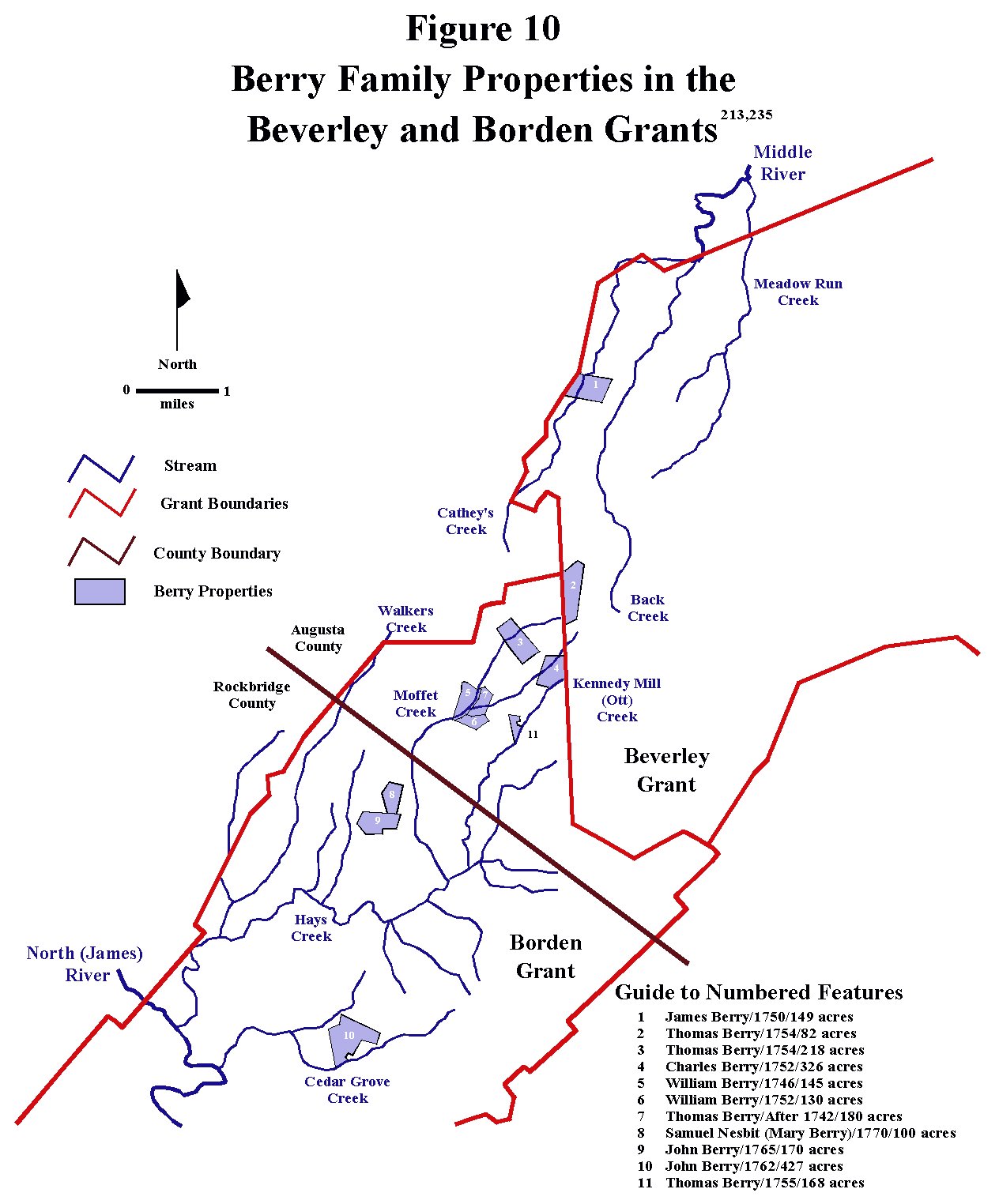
Around 1763 or 1764, John Berry married Jane Campbell, daughter of Hugh Campbell and Esther MaGill, in Augusta County, Virginia. Esther MaGill was another daughter of the Scotch-Irish immigrant William MaGill who settled along the North Shenandoah River in Augusta County, Virginia. By 1743 Hugh Campbell is known to have been living in Augusta County, Virginia near the North Shenandoah River (Figures 119 and 120). No documentation of Jane Campbell’s birth date and place have been found, to date, so information must be derived indirectly from other sources. Jane was baptized in the spring of 1743 at the Tinkling Springs Presbyterian Meeting House in Augusta County, and that date is probably quite close to her birth date (Figure 35). She was also, quite likely, close in age to John Berry, her husband, who was born in 1742 or 1743. Consequently, Jane’s birth date and place can be indirectly ascertained as taking place about 1743 in Augusta County, Virginia. Jane probably grew up on the Campbell family farm near the North Shenandoah River in northern Augusta County. It seems logical that the homestead of James Berry, the father of Jane Campbell’s future husband, John Berry, was also nearby, but no land ownership records can be found for this James Berry in Augusta County. This could mean that he was a squatter, and did not actually own any land yet, or that he rented his settlement site. It was not an uncommon practice for early Scotch-Irish settlers to occupy open land without bothering to immediately acquire legal ownership. Alternatively, he could also have been living near the rest of the Berry family. The core of early Berry settlement in Augusta County was a bit farther to south of the MaGill/Campbell homesteads in the southern part of the Beverley Grant and northern part of the Borden Grant (Figure 10), and it is equally likely that the James Berry family was living in this area. What is known with certainty is that when James Berry unexpectedly passed away in 1749, his estate was handled through the Augusta County courts, so the only certainty is that he was living in Augusta County, Virginia at the time of his death.
|
|
Since there were multiple marital connections among the Berry, Campbell and MaGill families, and a relatively small group of Scotch-Irish immigrants living in the area, it is not too surprising that the children of the intermarriages of these families would also find their mates from this pool of people. It is known with certainty that the MaGills and Campbells were adjacent neighbors, but it is only logical conjecture that leads to the conclusion that the James Berry family also lived nearby. Of additional interest is the fact that both James Berry (Jane’s future father in law) and William MaGill (Jane’s maternal grandfather) died in 1749. Although there is no documentation ascribing the cause of death of either man, it is certainly tempting to engage in some conjecture, specifically, that they may have both passed away from related events, for example, from hostile interactions with the Indians of the area, which was also not particularly uncommon, or possibly an accident. If they did, indeed, perish from the same event, it would be further indication that they lived near each other.
|
|
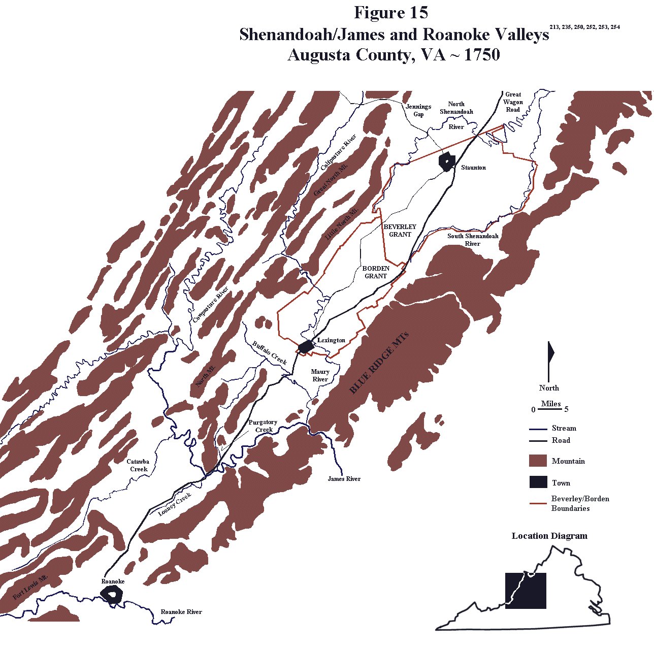
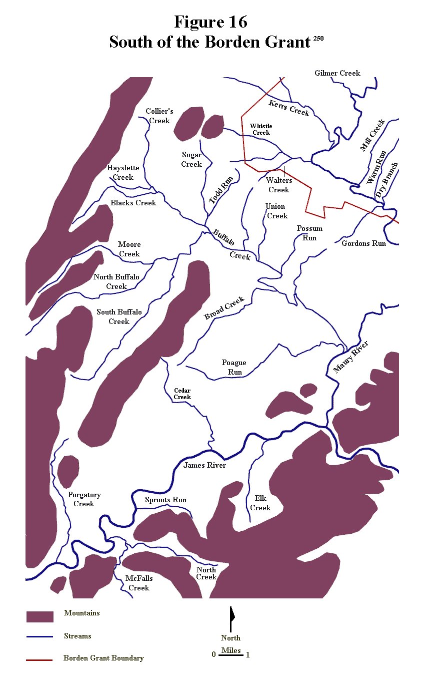
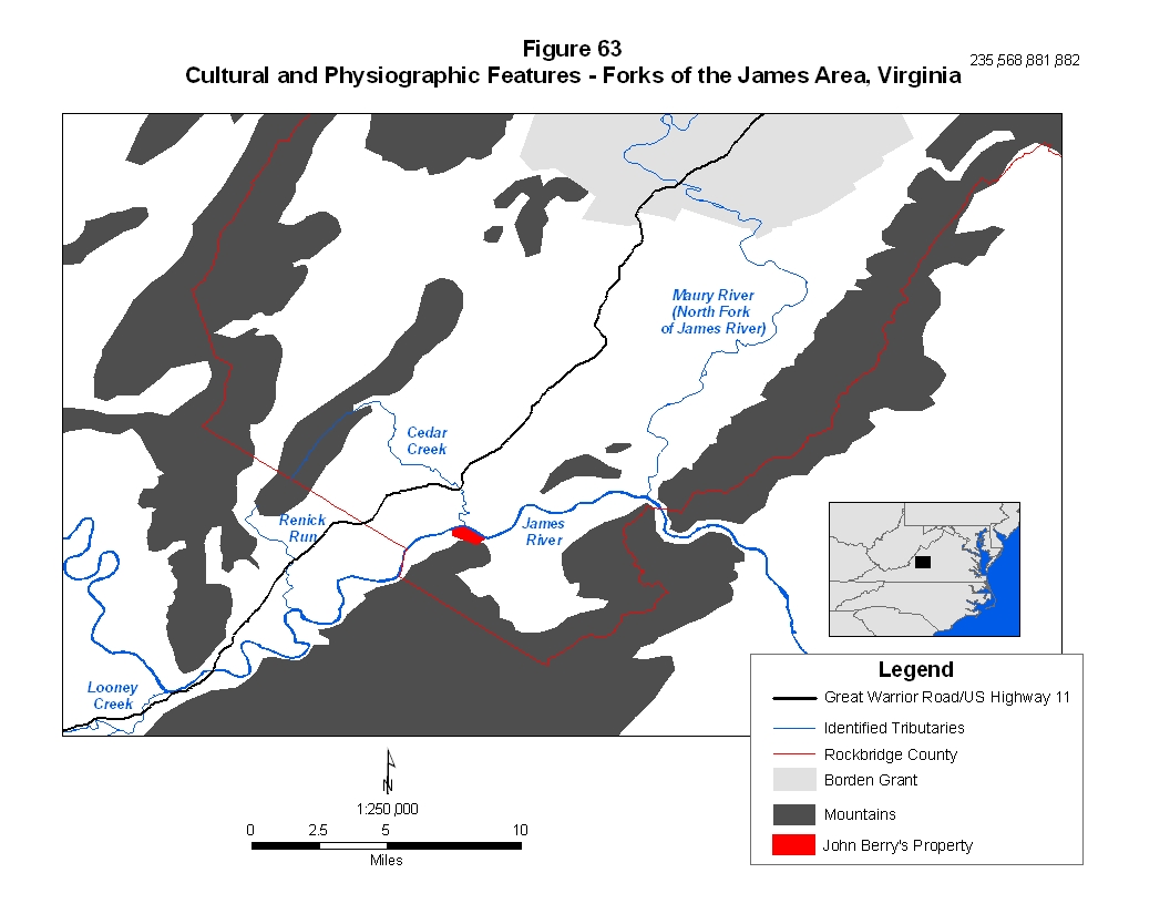
Not long after they were married John and Jane Berry moved to what was known as “the forks of the James”, the part of Augusta County that lay immediately south of the Borden Grant, where two major streams combined to form the James River just before it passes through a gap in the Blue Ridge Mountains. John and Jane remained in this area for several years (Figures 15 and 16). Sometime during 1772 they joined many of their Berry relatives and moved on to what would eventually become Washington County, Virginia in the southwestern corner of the state, (Figure 23). Here, they spent the rest of their lives rearing a large family of eight children. John Berry passed away quite young, while only in his mid forties, but Jane survived him for many years, living a long life, eventually spending her final time with her oldest son, Hugh Berry. Both Jane and John were buried in the Green Springs Presbyterian Cemetery in Washington County, Virginia. |
Timeline of John Berry and Jane Campbell
|
174321 |
Augusta County, Virginia Order Book 6, page 88 |
||||||||||||||||||||||||||||||||||||||||||||||||||||||||||||||||||||||||||||||||||||||||||||||||||||||||||||||||||||||||||||||||||||||||||||||||||||
|
10 April 1743100 |
A Berry History, An Account of John and Jane
Campbell Berry |
||||||||||||||||||||||||||||||||||||||||||||||||||||||||||||||||||||||||||||||||||||||||||||||||||||||||||||||||||||||||||||||||||||||||||||||||||||
|
15 May 1743567 |
The Tinkling Spring: Headwater of Freedom |
||||||||||||||||||||||||||||||||||||||||||||||||||||||||||||||||||||||||||||||||||||||||||||||||||||||||||||||||||||||||||||||||||||||||||||||||||||
|
28 Feb. 1750/51204 |
Augusta
County, Virginia Will Book No. 1, page 318 |
||||||||||||||||||||||||||||||||||||||||||||||||||||||||||||||||||||||||||||||||||||||||||||||||||||||||||||||||||||||||||||||||||||||||||||||||||||
|
28 Feb. 1750204 |
Augusta County, Virginia Will Book No. 1, page 319 |
||||||||||||||||||||||||||||||||||||||||||||||||||||||||||||||||||||||||||||||||||||||||||||||||||||||||||||||||||||||||||||||||||||||||||||||||||||
|
29 Aug. 1751205 |
Augusta County, Virginia Order Book 3 |
||||||||||||||||||||||||||||||||||||||||||||||||||||||||||||||||||||||||||||||||||||||||||||||||||||||||||||||||||||||||||||||||||||||||||||||||||||
|
29 Aug. 1751208 |
Augusta County, Virginia Order Book 3, page 187 |
||||||||||||||||||||||||||||||||||||||||||||||||||||||||||||||||||||||||||||||||||||||||||||||||||||||||||||||||||||||||||||||||||||||||||||||||||||
|
28 Nov. 175121 |
Augusta County, Virginia Order Book 24, page 439 |
||||||||||||||||||||||||||||||||||||||||||||||||||||||||||||||||||||||||||||||||||||||||||||||||||||||||||||||||||||||||||||||||||||||||||||||||||||
|
30 Nov. 175121 |
Augusta County, Virginia Order Book 3, page 225 |
||||||||||||||||||||||||||||||||||||||||||||||||||||||||||||||||||||||||||||||||||||||||||||||||||||||||||||||||||||||||||||||||||||||||||||||||||||
|
15 Mar 1758206 |
Augusta County, Virginia Will Book 2, page 226 |
||||||||||||||||||||||||||||||||||||||||||||||||||||||||||||||||||||||||||||||||||||||||||||||||||||||||||||||||||||||||||||||||||||||||||||||||||||
|
15 Mar. 175821 |
Augusta County, Virginia Order Book 6, page 88
|
||||||||||||||||||||||||||||||||||||||||||||||||||||||||||||||||||||||||||||||||||||||||||||||||||||||||||||||||||||||||||||||||||||||||||||||||||||
|
15 Mar. 1758206 |
Augusta County, Virginia Will Book 2, page 226 |
||||||||||||||||||||||||||||||||||||||||||||||||||||||||||||||||||||||||||||||||||||||||||||||||||||||||||||||||||||||||||||||||||||||||||||||||||||
|
15 Nov. 175821 |
Augusta County, Virginia Will Book 2, page 280 |
||||||||||||||||||||||||||||||||||||||||||||||||||||||||||||||||||||||||||||||||||||||||||||||||||||||||||||||||||||||||||||||||||||||||||||||||||||
|
~1763 |
Estimated Marriage Date Based on Birth of Eldest
Child |
||||||||||||||||||||||||||||||||||||||||||||||||||||||||||||||||||||||||||||||||||||||||||||||||||||||||||||||||||||||||||||||||||||||||||||||||||||
|
A Berry History, An Account of John and Jane
Campbell Berry |
|||||||||||||||||||||||||||||||||||||||||||||||||||||||||||||||||||||||||||||||||||||||||||||||||||||||||||||||||||||||||||||||||||||||||||||||||||||
|
Augusta County, Virginia Order Book 10, page 154 |
|||||||||||||||||||||||||||||||||||||||||||||||||||||||||||||||||||||||||||||||||||||||||||||||||||||||||||||||||||||||||||||||||||||||||||||||||||||
|
A Berry History, An Account of John and Jane
Campbell Berry |
|||||||||||||||||||||||||||||||||||||||||||||||||||||||||||||||||||||||||||||||||||||||||||||||||||||||||||||||||||||||||||||||||||||||||||||||||||||
|
A Berry History, An Account of John and Jane
Campbell Berry |
|||||||||||||||||||||||||||||||||||||||||||||||||||||||||||||||||||||||||||||||||||||||||||||||||||||||||||||||||||||||||||||||||||||||||||||||||||||
|
10 Sept. 17671198 |
Land Grant to James McDowell, Land Office Patents
No. 37, 1767-1768, p. 182 (Reel 37) |
||||||||||||||||||||||||||||||||||||||||||||||||||||||||||||||||||||||||||||||||||||||||||||||||||||||||||||||||||||||||||||||||||||||||||||||||||||
|
16 Mar. 176821 |
Augusta County, Virginia Order Book 11, page 501 |
||||||||||||||||||||||||||||||||||||||||||||||||||||||||||||||||||||||||||||||||||||||||||||||||||||||||||||||||||||||||||||||||||||||||||||||||||||
|
10 June 1768568 |
Augusta County, Virginia Deed Book 15, pages 229 -
233 BEGINNING at a Hiccory White Oak and
Dogwood on the River and running thence South fifty Degrees West forty two poles
to two Hiccorys North seventy seven Degrees West two hundred and ninety Poles to
two Dogwoods and Hiccory North fifteen Degrees West forty four Poles to two
Beachtrees and a Lynn on the River thence down the Several Courses of the same
three hundred and forty Poles to the BEGINNING and all Houses Buildings Orchards
Ways Waters Water courses profits Commodities Hereditaments and appurtenances
Whatsoever to the said Premises hereby granted or any part thereof belonging or
in anywise appertaining and the Reversion and Reversions Remainder and Remainers
Tents Houses and proffits thereof TO HAVE AND TO HOLD the said one hundred and
twenty Acres of Land and all and singular the Premises hereby granted with the
appurtenances with the said John Berry his Heirs Executors Administrators
and assigns from the Day before the Date hereof for and during the ful term and
time of one whole Year from thence next ensuing fully to be Completed and ended
YIELDING AND PAYING therefore the rent one pepper Corn on Lady Day next of the
same shall be lawfully demanded to the intent and purpose that by Virtue of
these Presents and of the Statute for Transferring uses into possession the said
John Berry may be in actual possession of the Premises & be enabled to
accept and take a grant and release of the Reversion & Inheritaqnce thereof to
him and his Heirs IN WITNESS whereof the said James McDowell hath hereunto set
his Hand and Seal the Day and Year first above Written |
||||||||||||||||||||||||||||||||||||||||||||||||||||||||||||||||||||||||||||||||||||||||||||||||||||||||||||||||||||||||||||||||||||||||||||||||||||
|
11 June 1768568 |
Augusta County, Virginia Deed Book 15, pages 229 -
233 BEGINNING at a Hiccory white Oak and Dogwood on the River and Runneth thence South fifty Degrees West forty two Pole to two Hiccory North seventy seven Degrees West two hundred and sixty Poles to two Dogwoods and a Hiccory North fifteen Degrees West forty four Poles to two Beach Trees and a Lynn on the River then down the several Courses of the same three hundred and forty Poles to the BEGINNING and all Houses Buildings Orchards Ways Waters Water courses profits Commodities Hereditaments and appurtenances whatsoever the said Premises hereby granted on any part thereof belonging or in any wise appurtaining and the reversion and Reversions Remaineer and Remainers Tents Houses and profits thereof and also all the Estate right title Interest use Trust property claim and demand whatsoever of them the said James McDowell and his Wife of in and to the said Premises and all Deeds Evidences and Writings touching on in any wise concerning the same TO HAVE AND TO HOLD the said one
hundred and twenty Acres of Land and all and singular other the Premises
Premises hereby granted and Released and every part and parcel thereof with
their and every of their appurtenances into the said John Berry his Heirs
and assigns forever to the only proper use and Behoof of him the said John
Berry and of his Heirs and assigns forever and the said James McDowell and
his Wife for themselves their Heirs Executors and administrators doth covenant
promise and grant to and with the said John Berry his Heirs and assigns
by these Presents that they the said James McDowell and his wife now at the time
of sealing and delivering these presents is seized of a good sure perfect and
Indefensible Estate of Inheritance and that they have good power and lawful and
absolute Authority to grant and convey the same to the said John Berry in manner
and form aforesaid and that the said Promises now are and so forever hereafter
shall remain and be free and clear of and from all former and other Gifts Grants
Bargains Sales Dower Right and Title of Lower Judgments Executions Titles
Troubles Charges and Incumbrances whatsoever made done committed or suffered by
the said James McDowell and his Wife or any other person or persons whatsoever
the Quitrents hereafter to grow due and payable to our Sovereign Lord the King
his Heirs and Successors for and in respect of the s.d Premises only excepted &
foreprized and Lastly that the said James McDowell and his Wife and their Heirs
all and singular the Premises hereby granted and Released with their
appurtenances unto the said John Berry and his Heirs and assigns against
them they said James McDowell and his Wife and their Heirs and all and every
other Person and Persons whatsoever shall and will Warrant and forever defend by
these IN WITNESS whereof they have hereunto set their Hands and Seals the Day
and Year first above Written. |
||||||||||||||||||||||||||||||||||||||||||||||||||||||||||||||||||||||||||||||||||||||||||||||||||||||||||||||||||||||||||||||||||||||||||||||||||||
|
7 July 176821 |
Augusta County, Virginia Will Book 4, page 135 |
||||||||||||||||||||||||||||||||||||||||||||||||||||||||||||||||||||||||||||||||||||||||||||||||||||||||||||||||||||||||||||||||||||||||||||||||||||
|
16 Aug. 1768568 |
Augusta County, Virginia Deed Book 15, pages 229 -
233 |
||||||||||||||||||||||||||||||||||||||||||||||||||||||||||||||||||||||||||||||||||||||||||||||||||||||||||||||||||||||||||||||||||||||||||||||||||||
|
10 Nov. 1768568 |
Augusta County, Virginia Deed Book 15, pages 229 -
213 |
||||||||||||||||||||||||||||||||||||||||||||||||||||||||||||||||||||||||||||||||||||||||||||||||||||||||||||||||||||||||||||||||||||||||||||||||||||
|
10 October 1770211 |
Augusta County, Virginia Will Book 4, page 404
|
||||||||||||||||||||||||||||||||||||||||||||||||||||||||||||||||||||||||||||||||||||||||||||||||||||||||||||||||||||||||||||||||||||||||||||||||||||
|
Botetourt County, Virginia Tithables 1770 – 1782,
1783 – 1789 |
|||||||||||||||||||||||||||||||||||||||||||||||||||||||||||||||||||||||||||||||||||||||||||||||||||||||||||||||||||||||||||||||||||||||||||||||||||||
|
Botetourt County, Virginia Tithables, 1770 – 1782, 1783 – 1789, Reel 149, The Library of Virginia, Land Tax Records, 1782-1900
A Seed Bed of the Republic, Early Botetourt, A Study
of Pioneers in the Upper (Southern) Valley, Virginia |
|||||||||||||||||||||||||||||||||||||||||||||||||||||||||||||||||||||||||||||||||||||||||||||||||||||||||||||||||||||||||||||||||||||||||||||||||||||
|
A Berry History, An Account of John and Jane
Campbell Berry |
|||||||||||||||||||||||||||||||||||||||||||||||||||||||||||||||||||||||||||||||||||||||||||||||||||||||||||||||||||||||||||||||||||||||||||||||||||||
|
5 Jan. 177356 |
Annals of Southwest Virginia 1769 - 1800 |
||||||||||||||||||||||||||||||||||||||||||||||||||||||||||||||||||||||||||||||||||||||||||||||||||||||||||||||||||||||||||||||||||||||||||||||||||||
|
12 Dec. 1773 |
A Berry History, An Account of John and Jane
Campbell Berry |
||||||||||||||||||||||||||||||||||||||||||||||||||||||||||||||||||||||||||||||||||||||||||||||||||||||||||||||||||||||||||||||||||||||||||||||||||||
|
Annals of South West Virginia 1769-1800, Brief of
Deeds Botetourt County, Deed Book No. 1 |
|||||||||||||||||||||||||||||||||||||||||||||||||||||||||||||||||||||||||||||||||||||||||||||||||||||||||||||||||||||||||||||||||||||||||||||||||||||
|
A Berry History, An Account of John and Jane
Campbell Berry |
|||||||||||||||||||||||||||||||||||||||||||||||||||||||||||||||||||||||||||||||||||||||||||||||||||||||||||||||||||||||||||||||||||||||||||||||||||||
|
26 Feb. 177756 |
Annals of Southwest Virginia 1769 - 1800 |
||||||||||||||||||||||||||||||||||||||||||||||||||||||||||||||||||||||||||||||||||||||||||||||||||||||||||||||||||||||||||||||||||||||||||||||||||||
|
1777-1780570 |
History of Southwest Virginia 1746-1786 |
||||||||||||||||||||||||||||||||||||||||||||||||||||||||||||||||||||||||||||||||||||||||||||||||||||||||||||||||||||||||||||||||||||||||||||||||||||
|
25 Nov. 177756 |
Annals of Southwest Virginia 1769 - 1800 |
||||||||||||||||||||||||||||||||||||||||||||||||||||||||||||||||||||||||||||||||||||||||||||||||||||||||||||||||||||||||||||||||||||||||||||||||||||
|
19 May 177856 |
Annals of Southwest Virginia 1769 - 1800 |
||||||||||||||||||||||||||||||||||||||||||||||||||||||||||||||||||||||||||||||||||||||||||||||||||||||||||||||||||||||||||||||||||||||||||||||||||||
|
19 May 177856 |
Annals of Southwest Virginia 1769 - 1800 |
||||||||||||||||||||||||||||||||||||||||||||||||||||||||||||||||||||||||||||||||||||||||||||||||||||||||||||||||||||||||||||||||||||||||||||||||||||
|
20 May 177856 |
Annals of Southwest Virginia 1769 - 1800 |
||||||||||||||||||||||||||||||||||||||||||||||||||||||||||||||||||||||||||||||||||||||||||||||||||||||||||||||||||||||||||||||||||||||||||||||||||||
|
18 Aug. 177956 |
Annals of Southwest Virginia 1769 - 1800 |
||||||||||||||||||||||||||||||||||||||||||||||||||||||||||||||||||||||||||||||||||||||||||||||||||||||||||||||||||||||||||||||||||||||||||||||||||||
|
19 Aug. 177856 |
Annals of Southwest Virginia 1769 - 1800 |
||||||||||||||||||||||||||||||||||||||||||||||||||||||||||||||||||||||||||||||||||||||||||||||||||||||||||||||||||||||||||||||||||||||||||||||||||||
|
A Berry History, An Account of John and Jane
Campbell Berry |
|||||||||||||||||||||||||||||||||||||||||||||||||||||||||||||||||||||||||||||||||||||||||||||||||||||||||||||||||||||||||||||||||||||||||||||||||||||
|
24 Nov. 178056 |
Annals of Southwest Virginia 1769 - 1800 |
||||||||||||||||||||||||||||||||||||||||||||||||||||||||||||||||||||||||||||||||||||||||||||||||||||||||||||||||||||||||||||||||||||||||||||||||||||
|
10 Dec. 178080 |
Washington County, Virginia, Will Book 1, page 117
|
||||||||||||||||||||||||||||||||||||||||||||||||||||||||||||||||||||||||||||||||||||||||||||||||||||||||||||||||||||||||||||||||||||||||||||||||||||
|
21 Mar. 178156 |
Annals of South West Virginia 1769-1800 |
||||||||||||||||||||||||||||||||||||||||||||||||||||||||||||||||||||||||||||||||||||||||||||||||||||||||||||||||||||||||||||||||||||||||||||||||||||
|
16 May 178121 |
Augusta
County, Virginia Will Book 6, page 173 £.s.d
Test Elijah McClenachan William
McFeeters |
||||||||||||||||||||||||||||||||||||||||||||||||||||||||||||||||||||||||||||||||||||||||||||||||||||||||||||||||||||||||||||||||||||||||||||||||||||
|
6 Aug. 178169 |
Washington County, Virginia Survey Record Book 1,
page 374 |
||||||||||||||||||||||||||||||||||||||||||||||||||||||||||||||||||||||||||||||||||||||||||||||||||||||||||||||||||||||||||||||||||||||||||||||||||||
|
16 Aug. 178169 |
Washington County, Virginia Survey Record Book 1,
page 42
15 June 1782 |
||||||||||||||||||||||||||||||||||||||||||||||||||||||||||||||||||||||||||||||||||||||||||||||||||||||||||||||||||||||||||||||||||||||||||||||||||||
|
21 Aug. 178156 |
Annals of Southwest Virginia 1769 - 1800 |
||||||||||||||||||||||||||||||||||||||||||||||||||||||||||||||||||||||||||||||||||||||||||||||||||||||||||||||||||||||||||||||||||||||||||||||||||||
|
24 Aug. 178169 |
Washington County, Virginia Survey Record Book 1,
page 37 |
||||||||||||||||||||||||||||||||||||||||||||||||||||||||||||||||||||||||||||||||||||||||||||||||||||||||||||||||||||||||||||||||||||||||||||||||||||
|
29 Aug. 178169 |
Washington County, Virginia Survey Record Book 1,
page 41 |
||||||||||||||||||||||||||||||||||||||||||||||||||||||||||||||||||||||||||||||||||||||||||||||||||||||||||||||||||||||||||||||||||||||||||||||||||||
|
Washington County, Virginia Will Book 1, page 74 |
|||||||||||||||||||||||||||||||||||||||||||||||||||||||||||||||||||||||||||||||||||||||||||||||||||||||||||||||||||||||||||||||||||||||||||||||||||||
|
20 Nov. 178156 |
Annals of Southwest Virginia 1769 - 1800 |
||||||||||||||||||||||||||||||||||||||||||||||||||||||||||||||||||||||||||||||||||||||||||||||||||||||||||||||||||||||||||||||||||||||||||||||||||||
|
1782491 |
Washington County, Virginia Personal Property Tax
List |
||||||||||||||||||||||||||||||||||||||||||||||||||||||||||||||||||||||||||||||||||||||||||||||||||||||||||||||||||||||||||||||||||||||||||||||||||||
|
22 May 178256 |
Annals of Southwest Virginia 1769 - 1800
|
||||||||||||||||||||||||||||||||||||||||||||||||||||||||||||||||||||||||||||||||||||||||||||||||||||||||||||||||||||||||||||||||||||||||||||||||||||
|
15 June 1782573 |
Land Office Grants, The Library of Virginia |
||||||||||||||||||||||||||||||||||||||||||||||||||||||||||||||||||||||||||||||||||||||||||||||||||||||||||||||||||||||||||||||||||||||||||||||||||||
|
16 June 178269 |
Washington County, Virginia Survey Record Book 1,
page 45 |
||||||||||||||||||||||||||||||||||||||||||||||||||||||||||||||||||||||||||||||||||||||||||||||||||||||||||||||||||||||||||||||||||||||||||||||||||||
|
16 July 178256 |
Annals of Southwest Virginia 1769 - 1800
Washington County Record of Deeds, page 82 |
||||||||||||||||||||||||||||||||||||||||||||||||||||||||||||||||||||||||||||||||||||||||||||||||||||||||||||||||||||||||||||||||||||||||||||||||||||
|
18 June 178269 |
Washington County, Virginia Survey Record Book 1,
page 162 |
||||||||||||||||||||||||||||||||||||||||||||||||||||||||||||||||||||||||||||||||||||||||||||||||||||||||||||||||||||||||||||||||||||||||||||||||||||
|
1783491 |
Washington County, Virginia Personal Property Tax
List |
||||||||||||||||||||||||||||||||||||||||||||||||||||||||||||||||||||||||||||||||||||||||||||||||||||||||||||||||||||||||||||||||||||||||||||||||||||
|
May 178374 |
Washington County, Virginia Judgement Book 1, page
14 |
||||||||||||||||||||||||||||||||||||||||||||||||||||||||||||||||||||||||||||||||||||||||||||||||||||||||||||||||||||||||||||||||||||||||||||||||||||
|
20 May 178356 |
Annals of Southwest Virginia 1769 - 1800 |
||||||||||||||||||||||||||||||||||||||||||||||||||||||||||||||||||||||||||||||||||||||||||||||||||||||||||||||||||||||||||||||||||||||||||||||||||||
|
16 Sept. 178356 |
Annals of Southwest Virginia 1769 - 1800 |
||||||||||||||||||||||||||||||||||||||||||||||||||||||||||||||||||||||||||||||||||||||||||||||||||||||||||||||||||||||||||||||||||||||||||||||||||||
|
18 Jan. 1785492 |
Washington County, Virginia Deed Book 1, page ? |
||||||||||||||||||||||||||||||||||||||||||||||||||||||||||||||||||||||||||||||||||||||||||||||||||||||||||||||||||||||||||||||||||||||||||||||||||||
|
21 Mar. 178656 |
Annals of South West Virginia 1769-1800
|
||||||||||||||||||||||||||||||||||||||||||||||||||||||||||||||||||||||||||||||||||||||||||||||||||||||||||||||||||||||||||||||||||||||||||||||||||||
|
1786100 |
A Berry History, An Account of John and Jane
Campbell Berry |
||||||||||||||||||||||||||||||||||||||||||||||||||||||||||||||||||||||||||||||||||||||||||||||||||||||||||||||||||||||||||||||||||||||||||||||||||||
|
15 Aug. 178680 |
Washington County, Virginia Will Book 1, page 117 |
||||||||||||||||||||||||||||||||||||||||||||||||||||||||||||||||||||||||||||||||||||||||||||||||||||||||||||||||||||||||||||||||||||||||||||||||||||
|
A Berry History, An Account of John and Jane
Campbell Berry |
|||||||||||||||||||||||||||||||||||||||||||||||||||||||||||||||||||||||||||||||||||||||||||||||||||||||||||||||||||||||||||||||||||||||||||||||||||||
|
11 Aug. 1787491 |
Washington County, Virginia Personal Property Tax
List |
||||||||||||||||||||||||||||||||||||||||||||||||||||||||||||||||||||||||||||||||||||||||||||||||||||||||||||||||||||||||||||||||||||||||||||||||||||
|
12 April 178882 |
Washington County, Virginia Will Book ?, page 132 |
||||||||||||||||||||||||||||||||||||||||||||||||||||||||||||||||||||||||||||||||||||||||||||||||||||||||||||||||||||||||||||||||||||||||||||||||||||
|
3 Oct. 1788491 |
Washington County, Virginia Personal Property Tax
List |
||||||||||||||||||||||||||||||||||||||||||||||||||||||||||||||||||||||||||||||||||||||||||||||||||||||||||||||||||||||||||||||||||||||||||||||||||||
|
21 Aug 1790491 |
Washington County, Virginia Personal Property Tax
List |
||||||||||||||||||||||||||||||||||||||||||||||||||||||||||||||||||||||||||||||||||||||||||||||||||||||||||||||||||||||||||||||||||||||||||||||||||||
|
21 Aug 1791491 |
Washington County, Virginia Personal Property Tax
List |
||||||||||||||||||||||||||||||||||||||||||||||||||||||||||||||||||||||||||||||||||||||||||||||||||||||||||||||||||||||||||||||||||||||||||||||||||||
|
21 Aug 1792491 |
Washington County, Virginia Personal Property Tax
List |
||||||||||||||||||||||||||||||||||||||||||||||||||||||||||||||||||||||||||||||||||||||||||||||||||||||||||||||||||||||||||||||||||||||||||||||||||||
|
21 Aug 1793491 |
Washington County, Virginia Personal Property Tax
List |
||||||||||||||||||||||||||||||||||||||||||||||||||||||||||||||||||||||||||||||||||||||||||||||||||||||||||||||||||||||||||||||||||||||||||||||||||||
|
20 Mar. 1804251 |
Washington County, Virginia Guardian &
Administrators Bonds |
||||||||||||||||||||||||||||||||||||||||||||||||||||||||||||||||||||||||||||||||||||||||||||||||||||||||||||||||||||||||||||||||||||||||||||||||||||
|
Federal Census Washington County, Virginia
|
|||||||||||||||||||||||||||||||||||||||||||||||||||||||||||||||||||||||||||||||||||||||||||||||||||||||||||||||||||||||||||||||||||||||||||||||||||||
|
1 June 1818859 |
Botetourt County, Virginia, Will Book C, page 138 |
||||||||||||||||||||||||||||||||||||||||||||||||||||||||||||||||||||||||||||||||||||||||||||||||||||||||||||||||||||||||||||||||||||||||||||||||||||
|
Federal Census Washington County, Virginia
|
|||||||||||||||||||||||||||||||||||||||||||||||||||||||||||||||||||||||||||||||||||||||||||||||||||||||||||||||||||||||||||||||||||||||||||||||||||||
|
27 Sept 1833100 |
A Berry History, An Account of John and Jane
Campbell Berry |
||||||||||||||||||||||||||||||||||||||||||||||||||||||||||||||||||||||||||||||||||||||||||||||||||||||||||||||||||||||||||||||||||||||||||||||||||||
|
1 June 1838100 |
A Berry History, An Account of John and Jane
Campbell Berry
In obediance to an order to me
directed by the court of Washington County, I have this day being first sworn
for the purpose, proceeded to state settle and adjust the administration account
of Hugh Berry Admr. with the estate of Jane Berry dec.d and report as
follows: |
||||||||||||||||||||||||||||||||||||||||||||||||||||||||||||||||||||||||||||||||||||||||||||||||||||||||||||||||||||||||||||||||||||||||||||||||||||
|
Family
History by Hugh Campbell Berry ... My grandfather, John Berry,
married Jane Campbell, I think in Virginia and perhaps were born in that
state, though I think both of Irish descent. They were married not far from
1765. |
|||||||||||||||||||||||||||||||||||||||||||||||||||||||||||||||||||||||||||||||||||||||||||||||||||||||||||||||||||||||||||||||||||||||||||||||||||||
|
4 Dec. 1859854 |
The
Nashville Christian Advocate, Dec 15, 1859, page 2, A Trip by the Book Agent to
Washington County
Monday morning, being furnished with an excellent horse, and accompanied by Dr. Heikell and Brother Wexler, we took a direction south of Abingdon, through what is technically called “the Knobs”. These are very singular elevations. They rise abruptly to a considerable height, and are covered with timber. You soon pass through these, and enter the valley of the “South Fork of Holston river.” On its margin, six miles from the town, stands the old family residence of my maternal grandparents. Here my mother, Jane Campbell Berry, was born and married; here her father died seventy three years ago; and here, in the same dwelling, her mother died many years afterwards, in her ninety third year. The house was among the first created in that portion of Virginia. Esq. Latham, who now lives on the adjoining farm, and who is now about eighty years of age, came to the neighborhood when he was five years old; he says the house was created before his recollection. It is said to have been a place of rendezvous where the settlers collected in early times, and protected themselves from the aggressions of hostile foes. I doubt it not. The house is made of wood, and leaks as though the rains of heaven had washed the timbers nearly away. It will soon moulder to dust.
Collecting a few pebbles from the margin of the river, and receiving a walking-stick, cut by my friend Dr. H. from a shrub growing near by, we bade adieu to the old family mansion, and turned our faces towards another point of interest.
In the churchyard I found the graves if many whose names had been made familiar by tradition; and there, too, was the dust of many of my kindred whom I had never seen in the flesh. A half-mile distant stood in early times the old, or first, Greenspring Church, which had disappeared, but the graves of the dead remain to indicate the place of its location; and there, in a strong enclosure, reposes the dust of both parents of my mother. I brought away the fragment of a stone, which I shall convey to my mother, who still lives in green old age.
|
||||||||||||||||||||||||||||||||||||||||||||||||||||||||||||||||||||||||||||||||||||||||||||||||||||||||||||||||||||||||||||||||||||||||||||||||||||
|
Family
History by Hugh Campbell Berry |
|||||||||||||||||||||||||||||||||||||||||||||||||||||||||||||||||||||||||||||||||||||||||||||||||||||||||||||||||||||||||||||||||||||||||||||||||||||
|
No date855 |
Sketches
of Prominent Tennesseans: Containing Biographies and Records, by William S.
Speer, published 2003, Genealogical Publishing Company, Tennessee |
||||||||||||||||||||||||||||||||||||||||||||||||||||||||||||||||||||||||||||||||||||||||||||||||||||||||||||||||||||||||||||||||||||||||||||||||||||
|
1894886 |
A
Reminiscent History of the Ozark Region: comprising a condensed general history,
a brief descriptive history of each county, and numerous biographical sketches
of prominent citizens of such counties, originally published by Goodspeed in
1894, republished by Ramfre Press, Cape Girardeau, MO, 1956 |
Analysis of the Timeline
|
John Berry was most born either in Augusta County, Virginia or Lancaster County, Pennsylvania in late 1742 or early 1743. Before the sparse records for him are examined, however, it is necessary to review the related court records from that time period that dealt with the death of his father, the distribution of his late father’s estate and the legal proceedings over the guardianship of young John Berry. In November of 1749, apparently not long after the death of his father, John’s mother, Elizabeth Eleanor (MaGill) Berry was appointed to administer the inventory and appraisal of her late husband’s estate. Several months later, in February 1750, she married John Jones and a month after that, in March 1750, the estate of her deceased first husband, James Berry, was inventoried and appraised at a value of just over £48. About a month and a half later, on the 26th of May 1750, the results were accepted by the court. Presumably, during this time, John’s mother and her second husband, John Jones, had custody of John Berry and his two brothers, and were responsible for the wealth and value of her first husband’s estate. About nine months later, in February 1751, for some reason, the elder James Berry, presumably the oldest member of the Berry clan in the area at the time and probably the brother of the orphan’s grandfather (who had not yet arrived in the Augusta County area), was appointed guardian of the orphaned boys and charged with the responsibility of ensuring that they receive any inheritance from the proceeds of their deceased father’s estate when they reached maturity. By late August 1751, however, it appears that there is some problem within the household of Elizabeth (MaGill) Berry and her second husband, John Jones, since the elder James Berry petitioned the court for custody of young John Berry due to misbehavior on the part of their step father. Several months later, in November of 1751, James Berry, the orphan’s guardian, complained to the court that the step father of the orphans had taken all or some of the proceeds from the estate sale of his wife’s first husband and used them for his own purposes rather than reserving the money for the orphans. By the spring of 1756 John’s guardian, the elder James Berry, was in ill health, and most likely passed away within the next year or so, since by the 15th of March 1758 John Berry’s maternal uncle, William MaGill, replaced the elder James Berry as the boy’s legal guardian. This William MaGill was a brother of Elizabeth Eleanor MaGill Berry Jones. The estate of John Berry’s maternal grandfather, William MaGill, Sr., was finally settled in the fall of 1758, and John Berry, along with his step father, John Jones, were mentioned as receiving monetary awards.
|
|
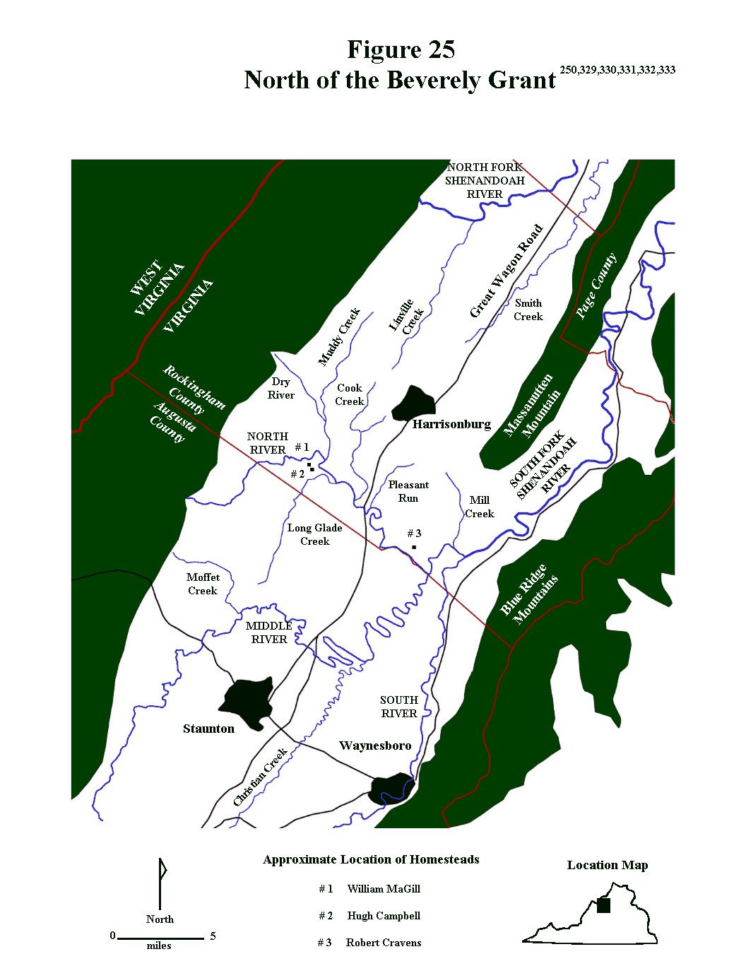
It is from the above noted guardianship records that the birth date of John Berry can be verified, since he is noted as being 15 years old in March 1758. John Berry’s birth date can, thus, be calculated as having occurred in late 1742 or in 1743, presumably sometime before March. His birth place is not known with certainty, but, as noted above, the Berry and MaGill clans were either living in Augusta County, Virginia at the time, or very soon to move there from Lancaster County, Pennsylvania. John Berry married his first cousin, Jane Campbell, about 1763, probably in Augusta County, Virginia, and, at the time, he would have been 19 or 20 years old, as was his bride. Jane’s mother and John’s mother were sisters – both being daughters of William MaGill, Sr. (the elder William MaGill). Jane Campbell, the daughter of Hugh Campbell and Esther MaGill, probably lived with her parents until she got married, and the Campbell family appears to have lived in the northern part of Augusta County near the North River not far from the MaGills. Until he got married, John Berry, likewise, probably lived either with his mother and stepfather (Elizabeth and John Jones) or with his guardian – his uncle, William MaGill, Jr. The latter seems more likely, since William MaGill was John’s legal guardian. Both John Jones and William MaGill lived in the North River area of northern Augusta County, so this is probably where John Berry grew up. (Figures 25, 35, 119 and 120)
|
|
John and Jane’s first child, Hugh Berry, was born in the fall of 1764 in Augusta County, Virginia. Where John and Jane were living at this time, other than somewhere in Augusta County, is not known with certainty, but, given that Jane’s parents and John’s guardian can both be documented as living in the northern part of Augusta County along the North Shenandoah River, that is probably where they were living when their first child was born. Sometime between 1764 and 1766, John’s step father and mother, John Jones and Elizabeth Eleanor (MaGill Berry) Jones, sold their land in the North Shenandoah River area of northern Augusta County and moved farther south in the county to the area referred to as “the forks of the James River”. (Figures 15 and 16) At the time the area was still part of Augusta County, but within just a few years, Augusta was reorganized and this area would become part of Botetourt County. (Figure 21) During the same time period (1764 – 1766), John and Jane Berry also moved to this area, as evidenced by the fact that in May 1766 John Berry was identified as a taxable male (a male over 16 years old) and ordered to work on an Augusta County road crew that was working in the forks of the James area. The timing of his mother and step father’s move to the area corresponds quite closely with the timing of John and Jane’s move to the area, so it is logical to assume that they could have moved to the area at about the same time – maybe even together.
|
|
In the May 1766 record, a land surveyor was appointed to survey land for road building. Road construction and maintenance was of critical importance during colonial times since good roads were required to get goods to market and maintain efficient lines of communications. Each road was assigned an overseer and all tithables males living on or within a few miles of the road were assigned the task of road construction and maintenance. They were also expected to provide their own tools, wagons and work animals, and to devote a minimum of six days every year to this effort. In this case all land owners and tithable males who lived between the lower end of John Bowyer’s property by Cedar Bridge to Matthew’s Road, were required to work on the roads. Nearly all of the men listed on the road crew with John Berry were also listed as taxable males in the Botetourt County tithable list a few years later in 1771.861
|
|
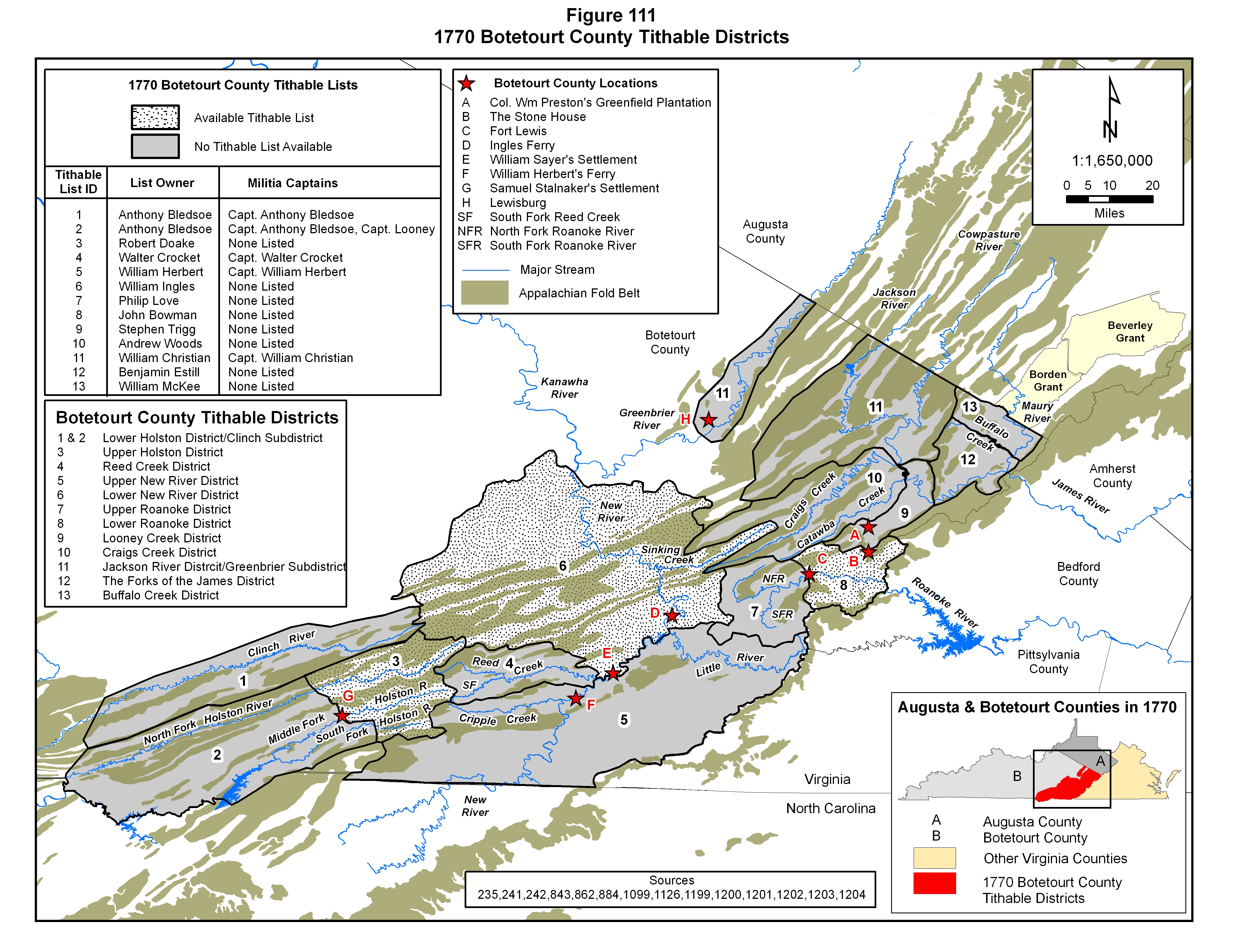
Several clues within the 1766 Augusta County road order entry allow for an approximation to be made of the location of John Berry’s property. Of particular importance are the descriptions of the road segments, John Bowyer’s plantation, Cedar Creek and Mathews Road. The general location of the road segment or segments running from north to south through the mountain valley in this area can be determined from earlier Augusta County Road Order records. In the fall of 1746 a road that had been marked out by several people, including John Mathews, was ordered to be cleared. This road segment extended from somewhere on the North fork of the James River to Looneys ford (presumably near Looneys Creek) on the south fork of James River. A few years later, in the fall of 1753, the court ordered that a road be cleared from the north fork of the James River near John Mathews Road to Renix’s Road (presumably near Renick Run) and that John Mathews was to be the overseer. While the exact location of the road segment over which John Mathews laid out and oversaw construction and maintenance cannot be determined from this data, it appears to start somewhere close to where the James River split into northern and a southern streams and extended southward along the south fork of the James River to Looney Creek. Most likely, it constituted an upgrade of the Great Warrior Path that extended along the valley of Virginia just west of the Blue Ridge Mountains. This road corresponds, roughly, to the modern day US Highway 11. The location of Cedar Creek is known with much more certainty. It empties into the south fork of the James River at about the midpoint of this stretch of road, and Cedar Bridge was most likely a bridge along the main wagon road where it crossed Cedar Creek. John Bowyer’s residence was noted as being near Cedar Bridge along the south fork of the James River. According to Augusta County historical accounts, Bowyer’s plantation fell in that part of Augusta County that eventually was split off to form Rockbridge County. The Cedar Creek drainage lies entirely within Rockbridge County, and the creek drains directly into the south fork of the James River. All of this background information points out a generalized region where John Berry’s property must have been located – within a few miles of the main road running down the length of the Great Valley of Virginia and near Cedar Creek. (Figure 63)33,861,864
|
|
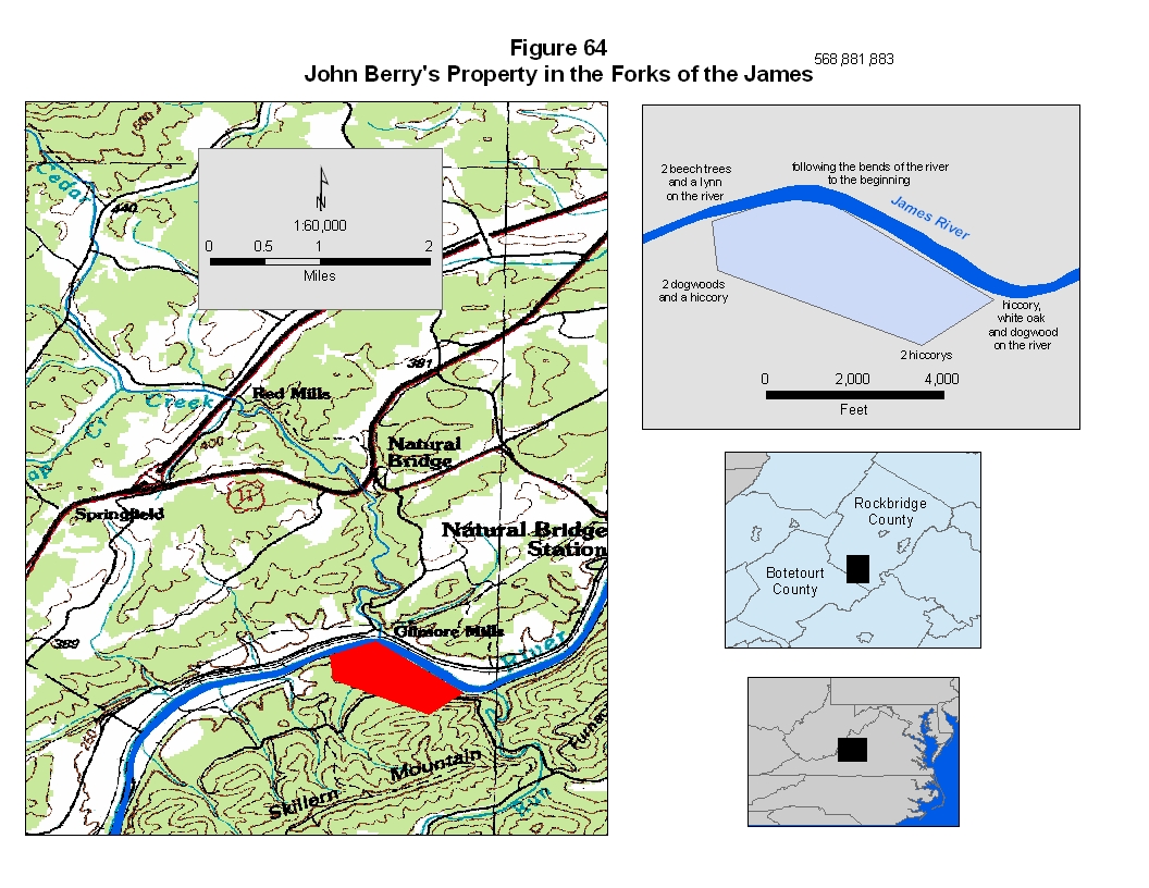
In the late summer of 1766, Jane (Campbell) Berry gave birth to their second child, William Berry. Around two years later (~ 1768) a daughter, Sally, was born. In March of that year (1768) hemp certificates were awarded to a number of farmers in the area, John Berry being one of them. It is quite clear from this entry that John Berry’s occupation was that of farming and at least one of the crops that he produced was hemp, which was a popular colonial cash crop marketed for cloth, paper and rope for the wooden sailing ships of the day. One of the other men receiving hemp certificates was John Hall, whose name appeared on John Berry’s 1766 road crew, as well as in the 1771 Botetourt County tithable list. In June of 1768 John Berry purchased 120 acres of land from James McDowell, a resident of James City County (which was where Williamsburg, the capital of the colony of Virginia, was located). The land he purchased was located on the south side of the James River and opposite the mouth of Cedar Creek (Figures 63 and 64). James McDowell had purchased the tract from the crown less than a year earlier, and sold it to John Berry for a significant profit, considering the original purchase price was only fifteen shillings and John Berry shelled out over 50 pounds for the same chunk of land. In early July of 1768 John Berry participated in an estate appraisal, then in August and November of 1768 there was continued paperwork related to his land purchase earlier in the year.843,857
|
|
In January 1770 Botetourt County was formed from part of Augusta County, with the new county line being established south of the present day Maury River and Kerr Creek .(Figure 63 and Figure 65) The area around Cedar Creek, where John Berry was listed as being a landowner, fell within Botetourt County after the boundary change. John’s grandfather, the elder John Berry, for whom the younger John Berry was undoubtedly named, wrote his will in the fall of 1770, bequeathing his grandson £6, which constituted just over 10% of the purchase price of this plot of land, if, indeed, this money was ever used for that purpose. The elder John Berry passed away sometime between October 1770, when the will was written, and March of 1771 in the following spring, when the will was submitted to court. In the meantime, John Berry was counted in the Botetourt County tithable list of 1771 as the owner of 100 acres, and, according to deed records, was living in the James River valley south of Buffalo Creek just across the James River from the mouth of Cedar Creek. The 1771 Botetourt County tithable list of Benjamin Estill further confirms this location. (Figure 112) This 100 acres clearly is the land he purchased from James McDowell in 1768 and the location corresponds to the area covered by the 1766 Augusta County road order identifying John Berry as a tithable male living in the area. For some reason 20 acres wasn’t counted in this assessment, possibly because it was lower grade land on a steep hillside or in floodable river bottoms. |
The Botetourt County Tithable Lists
|
During the colonial period, taxes, referred to as tithables, were imposed upon qualifying individuals (primarily free white males at least 16 years of age) who lived within a defined geographic area, here referred to as a tithable district. When Botetourt County was created, one of the first duties for the county court was to establish geographic boundaries for the tithable districts contained within the county boundaries. A prominent person, usually living within each district, was also assigned the responsibility of identifying all potential tax payers, and, presumably, to collect the taxes. Rather than affecting only land and property owners, as a property tax does, however, the tithables functioned as a tax imposed upon individuals who actually lived within a specified area, whether they owned the land on which they lived or not. Basically, this was a “head tax” – a tax on whatever qualifying individual was living in a specific area, so absentee landowners were not included on tithable lists. A related level of organization within each county was the militia company. All able bodied males within the colony were required to join the militia, and while militia units were organized on a county basis, overall command and control was in the hands of the royal provincial executive and legislative bodies, and, in particular, the royal governor. On the local level, militia units were organized into companies composed of settlers living within loosely-defined geographic areas within each tax district. Each company was commanded by a militia captain operating within a strict chain of command. In the early 1770s, depending on its size, areal extent and population density, each tithable district possessed one or more militia companies within its boundaries. The militia captains commanding these companies provided their political and military leaders with a list of the taxable (and draftable) males, who were, in most cases, heads of families living within their assigned areas. Without a doubt, the county court-designated tithable lists were intimately interwoven with the state-operated militia organizations. Although not all of these records have survived to the twenty first century, a number of them have, and they have serendipitously provided succeeding generations with valuable information on the families moving into and through these areas during this era of mass migration.56,241,242,864,1151,1152
|
|
On
the 10th of May in 1770, at one of the first meetings of the court for
the newly established Botetourt County, the boundaries of the tithable
districts were defined and list “owners” were assigned to each district.
Based on the legal descriptions provided by the court, and a comparison
to the basic topography and hydrology of the area, as represented in
Figure 111, the district boundaries were designed to conform to the
major drainage basins of the region. The 1770 tithable districts of
Stephen Trigg, Andrew Woods, William Christian, Benjamin Estill and
William McKee were defined within the James River drainage basin, except
for an inclusion of settlements along the Greenbrier River in Botetourt
County which were placed within William Christian’s list. John Bowman
and Philip Love’s districts were located within the upper and lower
portions of the Roanoke River drainage basin. The districts of Walter
Crocket, William Herbert and William Ingles were defined as being within
the New River basin, and Anthony Bledsoe and Robert Doak’s districts
were situated within the Holston River drainage basin. On 11 June 1771,
the Botetourt County Court reassigned list owners for some of the
established tithable districts, possibly modifying some of the district
boundaries slightly, and in 1772 the list owners were revised again.
Furthermore, the militia captains within each district did not remain
constant through this period, all, of which, has caused some difficulty
in making year to year list correlations. In order to more easily
reference specific districts over time, as well as the subordinate areas
within these districts (here referred to as subdistricts), each has been
identified with a hydrologic-related name as shown in Figures 111, 112
and 121. As far as the tithable lists themselves are concerned, there is
not complete preservation. Tithable lists from only three of the twelve
tithable districts established in 1770 have survived to the present day
although most of the tithable records for 1771 and 1772 are still
extant. Despite the drawbacks, the lists are extremely valuable tools in
tracing the movement of people during the early 1770s, particularly in
light of the fact that tithable lists for some of the areas covered by
these lists when Fincastle County was created in 1773 have not survived.
When Botetourt County was formed in 1770, it was generally assumed that
the county would be subdivided in the near future as the southwestern
part of the Virginia colony became increasingly populated with settlers
migrating out of relatively densely settled areas of the colony. A rapid
influx of English settlers into the area immediately followed a treaty
with the Cherokee in 1770, and it was only two years later, in 1772,
that Fincastle County was carved out of Botetourt County, significantly
reducing the latter county in areal extent. (Figure
65) 241,242,750 |
|
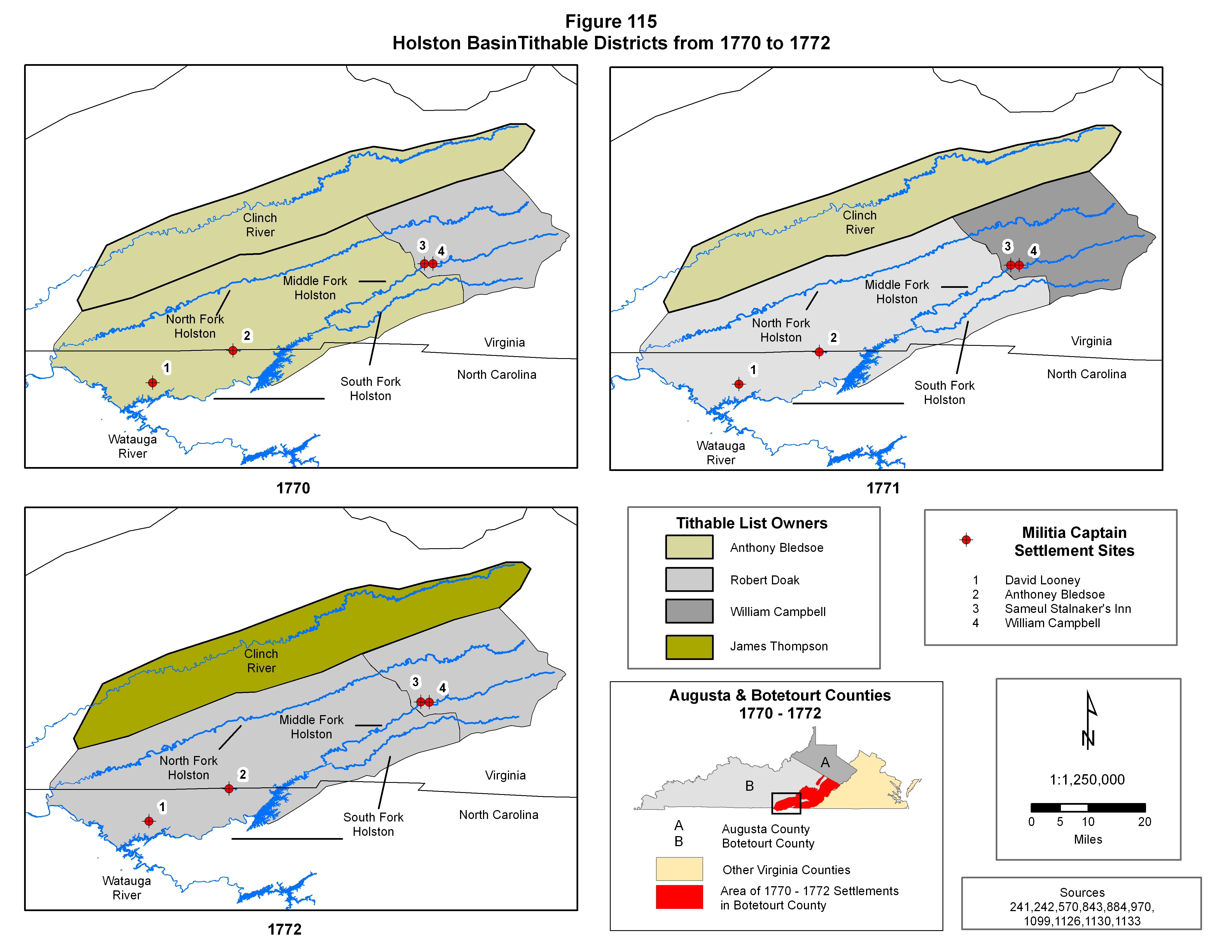
John Berry appeared once in the 1771 and twice in the 1772 Botetourt
County tithable lists, and in each of these three tax lists there are
two John Berrys, which means that two individuals bearing the name of
John Berry were being identified. As documented by several Botetourt
County deed records, one of these represents the John Berry who married
Jane Campbell and the other represents the John Berry who married Hannah
? (unknown last name). In 1771 both John Berrys were included on
Benjamin Estill’s list, here referred to as “The Forks of the James
District”, which, according to the Botetourt County court records, was
located in the valley between the mountain uplifts as along both forks
of the James River. (Figures
112,
121 and
123)
In 1772, both John Berrys first appeared in James McGavock’s list, who,
apparently took over “The Forks of the James District” tithable list
from Benjamin Estill that year, but later in 1772 they both appeared in
the Lower Holston Valley District, which was one of Robert Doaks’
tithable lists in the Holston Valley of southwestern Virginia. (Figures
115 and
122)
Although the units were not differentiated, both of the John Berrys
appeared on the Holston valley militia list of either Captain Looney or
Captain Bledsoe.241,242,750 |
|
The
actual tithable list for the 1771 Forks of the James District is not
alphabetical, so, at least to some extent, it probably shows individuals
as they were encountered by tax agent as he, or his agent, rode from
farm to farm creating the list of people to be taxed. This clearly
indicates that at least some of the people in this listing were probably
next door neighbors. John Jones (John Berry’s step father), the other
John Berry, as well as a James Berry are all listed immediately adjacent
to each other. Another John Berry lived somewhat farther away from this
Berry/Jones group, as evidenced by his nonadjacent occurrence in the
list and he was further identified as owning 100 acres of land. Based on
the documented 120 acre Augusta County land acquisition by John and Jane
Berry in 1768, the latter John Berry tithable list entry containing the
acreage most likely represents John Berry and Jane (Campbell) Berry.
That interpretation is further confirmed by the 1775 sale of that
particular parcel of land in which both John and Jane Berry are
identified as the sellers. Furthermore, several 1771 land acquisitions
and subsequent sales quite clearly show that John and Hannah Berry owned
land adjacent to John Jones, clearly identifying this John Berry as the
individual in the 1771 tithable list listed adjacent to John Jones. It
is of some interest and not too surprising to note that all of the
witnesses for John and Jane Berry’s 1775 land sale were also included in
the 1771 Botetourt County tithable list. One of the adjacent property
owners in the associated land description was a man by the name of
Dougherty, who, most likely, was one of the Doughertys listed in the
1771 Botetourt tithable list.56,196,557,568,836,838,841,843 |
|
As
noted above, both John Berrys appear in two separate tithable districts
in 1772 - “The Forks of the James District” and the “Lower Holston
District”. (Figure
111,
Figure 112 and
Figure 121)
Knowing that both men moved to southwestern Virginia from the forks of
the James, it is clear that the two 1772 lists in which they appear were
not collected simultaneously. After being “enumerated” in James
McGavock’s 1772 list in the forks of the James, both John Berrys moved
to the Holston valley in southwestern Virginia, arriving in time to be
“enumerated” a second time in one of Robert Doak’s 1772 tithable
districts. Another notable point in regard to the Botetourt tithable
lists is that both John Berrys completely disappear from all Botetourt
tithable lists after 1772 due to the fact that both men were living in
the newly created Fincastle County, which is highlighted by their
intermittent appearance in those records after 1772. Not only are these
the only Berrys in two of these particular tax lists (except for the
James Berry in James McGavock’s list), but each John Berry has only one
tithable male (a male over the age of 21) in the household, which means
that these tax entries represent either single males or married men with
no male children over the age of 16. In the case of John Berry and Jane
Campbell the latter is certainly true. Their oldest son, Hugh, was only
six years old at the time. That is also the case for the other John
Berry in these records, which is illustrated in the section of this
report covering John and Hannah Berry.56,196,557,568,750,836,838,841,843,864 |
|
It
was sometime in 1772 that another daughter, Nancy Berry, was born to
John and Jane Berry, and, at that time the family was probably still
living in Botetourt County. Around this time, 1772 to 1773, John Jones,
John Berry’s stepfather, passed away in Botetourt County. What became of
John Berry’s mother, Elizabeth Eleanor MaGill Berry Jones, following her
second husband’s death is not known at this time, and most likely will
never be known – that information being lost to the mists of history.
The next child of John and Jane Berry, John Berry, was born in early
December 1773, and by that time, the family was most definitely living
in Fincastle County, Virginia. Thomas Berry, their next child after
that, was documented as being born in Fincastle County in June of 1776.
One confusing fact that remains is that when John and Jane sold their
last bit of Botetourt County property in 1775, they were recorded as
being “of Botetourt County”, which suggests that they were still
residents of Botetourt County at the time of the sale. More than likely,
however, this notation indicates that they merely owned land in that
county at that time and clearly does not denote residency. In support of
this interpretation, through primary source records, it can be shown
that on 15 August 1775 Thomas Berry and his wife Esther, relatives of
John Berry, were living in Fincastle County, Virginia, but a land sale
they made on that date back in Augusta County, where they had lived
before moving to the Holston River valley, also listed them as being “of
Augusta County”. The deed notations suggesting residency clearly
indicate that the individuals identified were merely property owners in
the county where the sale took place and not necessarily residents.100,570 |
Multiple John Berrys
|
Compounding the problem of determining the timing of movements of John
and Jane Berry is the presence of another John Berry family in both
Botetourt and Fincastle County records. Much controversy has been
generated over the years among the descendants of these two individuals
bearing identical given and surnames. Part of the problem stems from the
peculiar Scotch-Irish affinity to use the same given names over and over
again. More particularly, however, the confusion stems from several
geographic and family connections, which are summarized below: |
|
1) |
Two Berry brothers, James and William Berry (sons of the elder John Berry), married daughters of William MaGill (Elizabeth and Jane MaGill, respectively). |
|
2) |
Both Berry/MaGill families lived in Augusta County, Virginia at the same time. |
|
3) |
Both Berry/MaGill families had a son they named John Berry. |
|
4) |
Both of these John Berrys were about the same age. |
|
5) |
On several occasions from the late 1760s through at least the middle to late 1770s, both John Berrys lived in the same county. Both John Berrys lived in the forks of the James area in Augusta and Botetourt Counties in the late 1760s and early 1770s, and both then moved to the Lower Holston valley of Botetourt and later Fincastle County in late 1772. |
|
6) |
Both John Berrys passed away in middle age.
|
|
When they appear in primary source records only with their first and last name it is exceedingly difficult to accurately differentiate them, and great care must be taken to assure that the correct assignment is made. There are, however, three diagnostic features that, when present, allow a clear differentiation and a firm basis for assigning specific primary source records to the correct individual. First, one of them was an orphan as documented by Augusta County court proceedings from the early 1750s. As evidenced by Augusta County records, orphan status is a rather rare occurrence in Berry source records from this era, so any source material that identifies one of them as having been an orphan allows for a definitive identification. Second, unsurprisingly, their wives names are different. One of the John Berrys married a woman named Hannah ? (unknown last name) and the other married Jane Campbell, so when records contain the name of their spouse, a definitive differentiation is quite easy. Jane Campbell was a daughter of Hugh Campbell and Esther MaGill, who was another daughter of William MaGill, so Jane Campbell brings a somewhat closer known family association with the MaGill family than the John and Hannah Berry family. Third, while both John Berrys moved from Botetourt County to Fincastle County, Virginia in late 1772, John and Hannah soon moved on to Lincoln County, Kentucky in the late 1770s while John and Jane spent the rest of their lives in the Fincastle/Washington County area. Both men can be traced through will, land and tax records, and, in John and Jane’s case, their land can be traced as it passed into the hands of their children after their deaths.
|
|
|
Hugh Campbell Berry, a son of Hugh Berry, John and Jane’s oldest son and therefore a grandson of John Berry and Jane Campbell, wrote a brief family history in 1875, which is extremely critical in understanding the orphan issue. The section of his family history narrative covering his paternal grandparents is reproduced below, and in this passage he notes that his grandfather was an orphan. He also noted that his grandfather, was an only child. This secondary source material clearly identifies which John Berry was the orphan. It also shows that Hugh Campbell Berry was unaware of the existence of his grandfather’s two older brothers, William and James. Definitive primary source data for these two brothers (William and James) is limited to the early 1750 Augusta County court records covering the orphans of James Berry, so it is quite likely that they either passed away when quite young, remained in Augusta County or left the area and never returned. The absence of Augusta County primary source records that can be definitively attributed to them, other than the orphan records, seems to support the interpretation that they passed away when they were young. In any case, their existence was clearly not known by their brother’s grandson by the late 1800s. In addition, the John Berry from the other Berry/MaGill family had a number of brothers and sisters, several of whom, remained in the Augusta County area at least until the mid 1790s, so it seems extremely unlikely that there would be any family history of that John Berry having been an orphan. All of the available evidence is indirect, but all of it points to the conclusion that the John Berry who married Jane Campbell was the Berry orphan documented in the Augusta County records and identified by Hugh Campbell Berry.29,100
|
|
|
|
|
Both John Berrys purchased land in “the forks of the James” area in the late 1760s and early 1770s. The “forks of the James” area is old terminology that refers to the area just west of the Blue Ridge Mountains where two large mountain streams merge to form the James River. During the 1770s the northern tributary was called the North River or the North fork of the James. Today, however, that northern fork is referred to as the Maury River and the southern “fork” is considered to be the true James River. The several John Berry land purchases in this area, in and of themselves, lend no clues that would allow the John Berrys to be differentiated. When these parcels of land were sold, however, as these men and their families prepared to move westward, their wives’ names were included in the land sales, and the associated source records can be correctly assigned on that basis. By this time, both John Berrys were married, and Virginia law required that wives be included in the sales process since they had a legal interest in the property. In addition, the land descriptions often included the names of adjacent land owners, which were useful in cross referencing the deed records to the available county tax records.
|
|
|
There are four Fincastle County data entries from between 1772 and 1774 and one Washington County court record from the fall of 1777 that contain none of the overt clues that would define which John Berry was responsible for the records: a Fincastle County petition requesting the services of a Presbyterian minister, a Fincastle County road order, a Fincastle County land record, a Fincastle County militia listing and a Washington County court record. Each will be examined and the logic for the assignment to a specific John Berry outlined.
|
|
|
On 5 January 1773 many of the Scotch-Irish settlers in the Ebbing and Sinking Springs congregations in the Holston valley of Fincastle County put together a petition requesting the services of their Presbyterian minister, Charles Cummings, who still presided over the Tinkling Springs congregation back in Augusta County. (Figure 35) Among the signers were several members of the extended Berry family, Thomas, James William and John. Of particular interest here is that only one John Berry signed the petition even though two John Berry can be documented as living in the area at that time. Quite clearly some of them had been living there for several years, as shown in Anthony Bledsoe’s 1770 Botetourt County tithable list, but the early January signing date, in the middle of winter, strongly suggests that any new arrivals must have been living in the area since the fall. Any new arrival, specifically John Berry, in order to have signed the document by 3 January 1773, would had to have been in the area at least by late 1772. During colonial times, when contemplating moving, it was not uncommon for people to harvest their last crop in the fall before picking up stakes and setting off for new lands. Travel was usually much easier in the fall than in the winter, and a new household could be set up while the weather was still tolerable. With John Berry being a signer of this document, although it is not specifically cited in any source, it seems quite logical to assume that this John Berry had moved to the area in the fall of 1772. The question of which John Berry this represents is a bit more problematical, and the lack of any of the diagnostic markers requires that a subjective assignment be made based on logical assumptions. The assumption here utilized is that, while the signer could have been either John and Hannah or John and Jane, given the fact that John and Hannah soon moved to Kentucky and that John and Jane spent the rest of their lives in this area, and had a strong association with the Presbyterian church in the area, coupled with the fact that both John and Jane were buried in the cemetery of that church, lends credence to the assignment of this entry to the John Berry who married Jane Campbell.56
|
|
|
Another of the problematical Fincastle County records consists of a road
order from 8 September 1773, and of particular interest are the names on
that list. Nearly all of the men on the segment of road that John Berry
was ordered to work on were also included on the Cummings Petition from
several months earlier in the year. More importantly, though, is the
fact that two of the names on the road order, Samuel Briggs and Benjamin
Logan, were also the names of the early settlers of Logan’s Fort (St.
Asaph’s) in Kentucky County, Virginia, including Benjamin Logan, one of
the original founders and namesake of the fort. The importance of this
connection lies in the fact that John and Hannah appear to have moved to
Kentucky in late 1777 and they ended up living very close to Logan’s
Fort. In addition, to Samuel Briggs and Benjamin Logan, George Clark,
Thomas Montgomery and John Kennedy were signers of the Cummings Petition
and are also listed as early settlers of Logan’s Fort in Kentucky. It
seems quite logical to assume that these men, while working on the road
crew, would take the opportunity to discuss emigrating to the new lands
opening up in Kentucky. On that basis, it seems logical to assign this
road order entry to John and Hannah Berry.56,844 |
|
|
|
|
The
third problematical Fincastle County John Berry record consists of a 139
acre land purchase on Wolf Creek, a tributary of the South Fork of the
Holston River. The land was surveyed in the early winter of 1774 with
actual settlement made in 1772. It was resurveyed in 1781 and that
record reveals a lengthy ownership history. The final owner was Samuel
Duff, but he had been assigned the land by John Berry, and the trail of
assignees included Thomas Berry, Andrew Colvin and William McMullan. Of
much more critical interest is the fact that it was a Loyal Land Company
sale made directly to John Berry. The Loyal Land Company was a private
organization that had been granted large allotments of land and a fairly
limited time period in which to sell those lands. The time frame had
been interrupted by the French and Indian War and was unofficially
extended after the war. The land cost was £3 per 100 acres plus some
service fees and a land survey charge of just over £3. Most of the
company’s sales were to squatters, and, in fact, company representatives
typically identified company land by the simple fact that squatters were
there. These people were then forced to pay up or move on. With a
settlement date of 1772, a survey date of 1774, a Loyal Land Company
sale to John Berry, a subsequent transfer of ownership, and the fact
that John and Hannah Berry soon moved on to the Logan’s Fort area of
Kentucky County, Virginia, it seems logical to assign this record to
John and Hannah Berry. This property can be located on
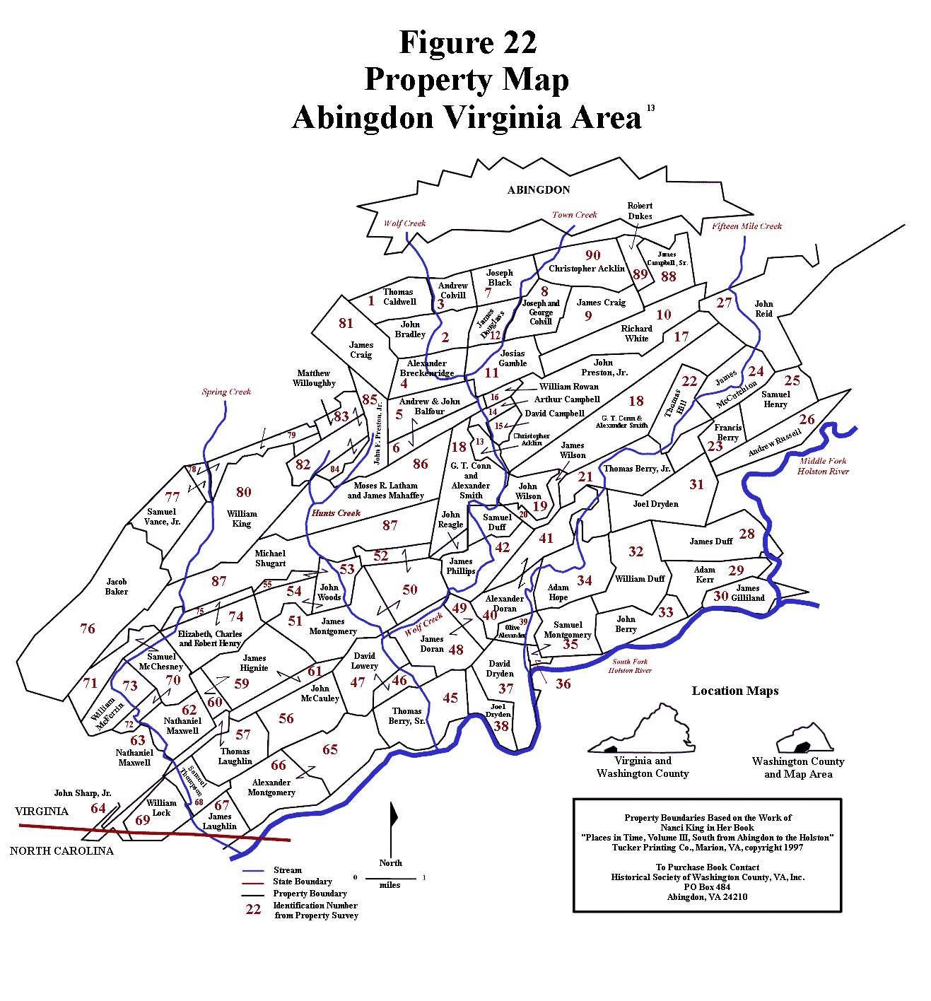
Figure 22
as the 139 acre tract eventually purchased in 1781 by Samuel Duff along
Wolf Creek. This situation most likely did not sit well with John Berry,
and may have been a factor in eventually John and Hannah soon deciding
to move on to Kentucky. Further supporting the assignment of this land
to the John and Hannah Berry lineage is that fact that John and Jane can
be documented by Washington County land survey records to have met the
minimum requirements for settlement on a separate tract of land along
the South Fork of the Holston River in 1770. Since they were still
living in the forks of the James at his time, actual settlement most
likely constituted the planting of a corn crop or maybe the construction
of a crude living structure, as was the common practice of the time.
John and Jane finally acquired title to that land in the early 1780s,
long after John and Hannah had moved on to Kentucky. In fact, they spent
the rest of their lives there on the Holston River, so it seems highly
unlikely that they would have also laid claim to another noncontiguous
land parcel a year or two later. This data is examined in more detail in
subsequent paragraphs.856 |
|
|
The fourth problematical Fincastle County John Berry record constitutes a militia listing for 1774. A John Berry was included on Captain William Russell’s militia list for service in the Battle of Point Pleasant against the Shawnees and their allies which took place on 10 October 1774 at the point where the Kanawha River empties into the Ohio River in present day West Virginia. William Russell’s company was recruited from settlers living in and around his private fort at Castlewood, which is located in the Clinch River valley. Since John Berry and Jane Campbell spent their lives in the Wolf Creek settlements along the South Fork of the Holston River near modern day Abingdon, in Washington County, Virginia, it does not seem likely that they were living in further west in the Clinch River valley. Furthermore, Castlewood served as a jumping off point for settlers migrating westward to Kentucky, which is exactly what John and Hannah Berry did by the mid to late 1770s. Consequently, it seems logical to assign this militia record to John and Hannah Berry.885
|
|
|
The final John Berry record in question is a 1777 Washington County court record that promoted John Berry, among others, to the rank of lieutenant in the Washington County Virginia militia. Three pieces of information are necessary to correctly assign this entry: an understanding of the historical sweep of events affecting the “overmountain” settlers, a Washington County court case stemming from the Battle King’s Mountain, which took place in the fall of 1780, and the timing of John and Hannah Berry’s move to Kentucky.
|
|
|
Analysis of the historical element involves obtaining an understanding of the importance and role of the local militias. Militias were county-based, state sponsored and controlled armed forces of citizens. The participation of all available able-bodied free males was required by the colonial government during times of emergency, and the combined British-Cherokee threat in this part of the country during the Revolutionary War certainly qualified for that. At the local level the militias were led by a colonel, followed in rank by captains who were in charge of the local militia volunteers who typically lived nearby a defensive facility. A number of the young men in the extended Berry families living in Fincastle County at this time were of militia age and it is inconceivable to think that were not members of these local militias. Unfortunately, there were no unit histories written for these militia units and very little primary source material is available documenting their membership. There is, however, a sufficient amount of information describing the events that occurred in this area during this time period that involved these militias. There is also some available information to indicate that the Berry men living in Fincastle County at this time participated in the events that involved the militia, so, by tracing the history of the area as a whole, and understanding that the Berry men participated in these events, a better understanding of the life experiences of these families can be obtained, and the John Berry records in question can be accurately assigned.462,570,865,866
|
Historical Background
|
After suffering significant manpower losses from a pivotal territorial battle with the Chickasaws along the western edges of their territories in 1769, the Cherokees found themselves in a very weakened position, soundly defeated by competitors on the western margins of their territory and forced to negotiate territorial claims with the Europeans encroaching from the east. The result was a treaty with the British government in 1770 that re-established the boundary between white and Cherokee lands, moving it significantly west of the line established by the Proclamation of 1763. That proclamation by the King of England stated that all English settlers were restricted to the river basins that drained into the Atlantic Ocean, and this westward extension clearly represented an abandonment of that political understanding. The Holston, Clinch and Powell valleys of southwestern Virginia ultimately drain into the Gulf of Mexico. Not unexpectedly, this sparked a rapid influx of European settlers, mostly from the North Carolina and Virginia colonies. These new immigrants created numerous settlements and fortifications in the Holston, Clinch and Powell valleys, with cabins and defensive fortifications appearing southward as far as present day northeastern Tennessee. The bulk of the immigrants settled in the Holston valleys (the North, Middle and South forks of the river), since it was larger, provided more opportunities for settlement, and was typically the first valley encountered by the new European settlers streaming in from Virginia. A significantly smaller number of people settled in the Clinch valley and only a few made it as far west as the Powell valley. The peak year of settler influx was 1773, followed by a drop off in 1774 as hostilities between whites and Indians grew. After the Battle of Point Pleasant in the fall of 1774, where the Shawnees from the north were defeated, there was another, albeit much smaller influx of new settlers.462,570,865,866
|
|
The change in the political situation generated a great deal of resentment on the part of the Cherokees and Shawnees, especially the Cherokee who had occupied these lands for hundreds of years. In the early 1770s, resistance to white encroachment primarily came from roving bands of Shawnee warriors from north of the Ohio River, but the Battle of Point Pleasant in the fall of 1774 effectively, albeit temporarily, greatly diminished Shawnee efforts to stem the tide of European migration. The Cherokees were slowly regaining strength through the early to mid 1770s, and became increasingly involved in the efforts to thwart the European advance. It was the American Revolution, however, that provided them with the impetus to execute their goals of territorial reoccupation. Through the early to mid 1770s, relations between the American colonies and Great Britain rapidly deteriorated to the point of open revolution. By the time war finally broke out, the British had instigated a strategy of using British and Loyalist troops to attack the rebels from the sea while simultaneously taking advantage of their already aggrieved Indian allies to pressure the American rebels from the frontier. Consequently, numerous British agents visited the western tribes with arms, supplies and cash, inciting them to take up arms against the English colonists. The Cherokees, being eager to regain their lost territories, readily agreed and became increasingly aggressive. This, of course, greatly alarmed the settlers in the Powell, Holston and Clinch valleys of Botetourt and later Fincastle counties, who responded by organizing into militia units.462,570,865,866
|
|
In July 1776, as open conflict between the American rebels and the British homeland erupted, the British, along with their Indian allies, developed a plan to eradicate settlers from these valleys once and for all. An assembled force of 700 warriors, predominantly Cherokee, but also including Shawnee, Delaware and Mohawk warriors was split into two groups. The dissident Cherokee chief Dragging Canoe was to attack the Nolichucky and Watauga settlements with half of the warriors while Raven was to lead the rest up the Clinch and Holston valleys to break up those settlements. Getting word of the impending attacks, the southernmost settlements along the Nolichucky River were abandoned and the refugees fled northward to the protection of the only nearby fortified positions - Eaton’s Fort near the Long Island of the Holston River and the fort on Watauga Creek (Watauga Fort). Finding the Nolichucky settlements abandoned, Dragging Canoe split his force again, sending Old Abram to lead an attack against the settlements on the Watauga Creek while he took the bulk of his force, nearly 200 warriors, to assault Eaton’s fort. (Figure 66) At this time the North Carolina settlements were governed by Virginia authority, so they looked to their neighbors in Fincastle County, Virginia for assistance. As the Nolichucky refugees poured into the two fortifications, word of the Indian onslaught was sent out to the nearby Virginia militia units at Thompson’s Fort, Edmiston’s Fort, Cocke’s Fort, Shelby’s Fort and the settlements near Wolf Creek. The next day, 20 July 1776, 170 members of the Virginia militia from in and around these locations quickly concentrated at Eaton’s Fort. Rather than wait for the inevitable defensive battle, or worse yet, sitting behind walls as the Cherokee looted their properties and killed stragglers, the militia army opted to go on the offensive and attack the approaching force. Two divisions marched toward Long Island, about seven miles away. Several miles short of their target a small group of Indians, loaded with plunder was encountered and attacked. As the Indians fled back to the nearby main Cherokee force, the militia, expecting a quick attack, fell back about a mile toward high ground. The counter attack came quickly as the main Cherokee force soon caught up with the settlers. Finding the settlers in apparent retreat, the Indians attacked, expecting an easy victory from an enemy that appeared to be in retreat already. The militia quickly formed a quarter mile long line of battle along the crest of a small ridge as the Cherokee attacked their center and left flank. The fighting soon devolved to bitter hand to hand combat, lasting from 30 to 45 minutes, but ending as quickly as it began with the rapid withdrawal of the Indian force. The militia suffered no losses and only two four minimally wounded men, while Indian losses were somewhat higher, with at least 13 known dead and many more wounded. Dragging Canoe was seriously wounded during the clash and soon withdrew his force form the field. Meanwhile, after an initial unsuccessful assault on Fort Watauga, Old Abram’s force settled into siege, but failed to overcome the fort’s defenses, and after two weeks, gave up. This battle of Long Island Flats, was the first clash of the Revolutionary War that took place west of the mountains and, especially coupled with the follow-up campaign, was considered to be an overwhelming victory for the settlers.462,570,867
|
|
The militia returned to Eaton’s fort immediately after the battle, but with Raven’s force wrecking havoc in the lower Holston and Clinch River valleys, the Virginians quickly headed back to defend their homes and families. The only safe zone in the vicinity was now Black’s Fort, situated where the present city of Abingdon, Virginia is now located. For the next few days, Raven’s warriors killed and scalped settlers, looted and burned their homes and scattered their livestock, as they made their way through the area, eventually reaching as far north as 7 Mile Ford. Refugees from the affected areas streamed into the fort and on the eve of the battle of Long Island Flats, at least 400 men, women and children had left their homes for the safety of the fort. The Cherokee were mostly an unorganized force, roving the countryside in small bands, and one such band that was busy burning and plundering homes in the Wolf Hills settlement about eight miles south of the fort was attacked by Virginia militia members that had ventured out from the fort. Eleven Indians were killed in the encounter and their scalps were brought back to the fort where they were attached to a tall pole at the gate of the fort.462,570
|
|
Eventually, after the Watauga siege was lifted, the Cherokee withdrew
from the area, and the settlers quickly reoccupied the territory. Col.
Christian, leading a force of 1,800 Virginia and North Carolina militia,
soon launched a punitive raid against the Cherokee, coordinated with
similar raids by the North and South Carolina militias. From October
through December Col. Christian’s army marched southward into the heart
of Cherokee territory, burning villages, destroying crops, capturing
British supplies and killing livestock as a force of North Carolina
militia and another force of South Carolinians, approached from farther
south and to the east, doing the same in a giant pincer movement. All of
the major Cherokee towns were destroyed in the process with obviously
devastating effects due to the oncoming winter season. Another, much
smaller punitive expedition was mounted in April 1777. The Cherokee sued
for peace, which ended the expedition, and made additional territorial
cessions that were formalized in a treaty with the North and South
Carolinians in May 1777 and the Virginians in July 1777. In these
agreements, the Cherokee gave up all of their claims to contested lands
in the Nolichucky, Watauga, Holston and New River valleys in addition to
other territorial cessions with North and South Carolina. Col.
Christian’s casualties were very light, resulting in only one killed and
several wounded, with several of the latter being Berry men. At the
close of the campaign Col. Christian withdrew, stationing 600 men at the
Long Island of the Holston and 80 men at Rye Cove for longer term
defensive militia duty. The rest were mustered out of service. A hostile
element of frustrated and disgruntled Cherokee, led by Dragging Canoe,
broke away from the main group of Cherokee and withdrew to the
Chickamauga Creek area in the vicinity of modern day Chattanooga,
Tennessee, located at a well known British trading post. From this base
they continued to be supplied with arms, especially after the Georgia
colony fell to British troops in late 1778, and this allowed them to
continue hostile actions against the settlers.570,868,869,870 |
|
These historical events describe the dangerous conditions endured by the frontier settlers living in the Holston, Clinch and Powell valleys in the mid to late 1770s, as well as the response of the settlers to these threats. At the time of the Cherokee Uprising of 1776, John Berry and Jane Campbell were living in Fincastle County, probably on or near the property they eventually purchased along the South Fork of the Holston River and part of the Wolf Hills settlement located about six miles south of the modern day town of Abingdon, Virginia. This places them right in the middle of the area that was subject to the roving bands of Raven’s Cherokee warriors who were attempting to eliminate the very settlements where several Berry families lived. No doubt John and Jane Berry, with their family of six children, ranging in age from two months to 12 years old, formed part of the mass of frightened settlers seeking shelter in Black’s Fort. Furthermore, it is inconceivable to think that John Berry or any of the other Berry families living under these conditions did not take up arms against these threats as part of the local militia. In late December 1776 Fincastle County, Virginia was dissolved and replaced by three counties, Montgomery, Washington and Kentucky. (Figure 65) One of the items of business when the Washington County court met in February of 1777 was to recommend promotions to the rank of lieutenant for a number of local militia members, no doubt based upon their actions in the recent conflicts. Six of the names on this list had also been signers of the Cummins petition, and one of these names was John Berry. Both John Berrys were living in Fincastle County at this time, and, most likely, both Berry families were holed up in Black’s Fort during Raven’s attacks, which complicates the interpretation. There are, however, several factors that allow for an accurate assignment of this record. First of all, Washington County records from May of 1783 note that a militia unit under the command of Lt. John Berry, stole a hog, no doubt butchering and eating it, while involved in the Kings Mountain campaign in October 1780. Quite clearly, the John Berry who had been promoted to lieutenant in February of 1777 was still living in the vicinity in the fall of 1780, as well as the spring of 1783. The timing of John and Hannah Berry’s move to Kentucky, then, becomes a critical factor in correctly assigning this record.
|
|
John and Hannah Berry are known to have been living in the part of Kentucky County, Virginia that would soon be organized into Lincoln County by the spring of 1780, since one of their children, Hannah, can be documented as being born there at that time. (Figures 65 and 67) When they moved there is a bit more difficult to determine, and four pieces of data may be helpful in making this assessment. During the mid to late 1770s a large number of settlers had been migrating into Kentucky and illegally occupying prime Bluegrass farm country – illegal in the eyes of the colonial government of Virginia at least, since all of this land was claimed by Virginia and much of it had already been surveyed for Virginia war veterans. To address the problem of overlapping land claims, as well as to encourage these settlers to remain in Kentucky and secure the land from Shawnee and Cherokee territorial claims, Virginia established a land commission whose officials reviewed all claims of residency and offered pre-emption certificates consisting of 400 acres of land at a cost of $9 (the rate was $2.25 for 100 acres up to 400 acres) for anyone who could show that they had actually settled in Kentucky before 1 January 1778. Those who had made improvements, such as building a cabin, were allowed an adjacent 1000 acres for the price of $400. These figures compute to $2.50 an acre for the 1000 acre plot and just over 2¢ an acre for the first 400 acres. The land certainly wasn’t free, but it was quite inexpensive even for those times. According to Kentucky land records, John and Hannah never received a pre-emption certificate for 400 acres, nor the additional 1000 acre property improvement allotment. This suggests that they did not qualify for the preemptions because they were not yet in Kentucky by 1 January 1778. However, a Lincoln County record from the fall of 1781 notes that John Berry, along with a number of other citizens, were able to prove to the satisfaction of the Lincoln County court that they had not been able to procure lands at the state price, and a surveyor was ordered to lay off 400 acres for each approved individual. This court record seems to indicate that John and Hannah were, indeed, in Kentucky prior to 1 January 1778, and that they were belatedly awarded the equivalent of a 400 acre preemption certificate.20,196,556,564,847,848,850
|
|
The timeline can be constrained a bit more with the evidence of militia and public service claims data from Fincastle County and from the Logan’s Fort militia lists. John Berry can be documented as living near William Russell’s fort at Castlewood in modern day Russell County, somewhere along the Clinch River drainage through the summer and fall of 1774 when he served in the militia from that area during the Point Pleasant Campaign. (Figure 82) After the battle, he made a public service claim for a gun he lost during the campaign. This claim was made to the state-sponsored commission handling payment to the militia and those who provided material support during the campaign. This commission was established in mid July 1775, and public hearings were held throughout the fall of 1775 where the various claims were presented to them. Since a public service claim was submitted by John Berry when the commission met in Fincastle County, it can be reasonably asserted that he was still living in Fincastle County, and probably still in the vicinity of William Russell’s fort at that time. Logan’s fort, originally called St. Asaph’s Fort, was established in Kentucky the following spring (early May of 1775) by Col. Benjamin Logan and others, although John and Hannah Berry were not among that group of original settlers. Presumably, at this time, they were still living in the Castlewood area. The land where John and Hannah eventually settled, however, was on Hanging Fork Creek, which is very close to Logan’s Fort. During the Indian unrest in Kentucky during 1777, a militia was formed by Captain Benjamin Logan at Logan’s Fort, presumably containing a listing of all able bodied males to aid in the defense of their frontier homes. There was no John Berry on this list, so it can be safely assumed that the family was not yet in the area by the summer of 1777. Sometime before the end of the year, however, they must have arrived in the area in order to, belatedly, become qualified for a 400 acre pre-emption. This line of evidence seems to bracket the time of their move from Fincastle County to Kentucky County, Virginia as taking place between the late summer of 1777 and 1 January 1778.20,196,556,564,847,848,850,885
|
|
From this analysis it is clear that the John Berry who married Hannah was living in the Fincastle/Washington County area at least until late 1777. Furthermore, he was a member of the local militia and, most likely, participated in the fights with the Cherokee. By the time the Washington County militia was called up to participate in the King’s Mountain battle in October of 1780, however, he had left the area and had been living in Kentucky County, Virginia for about two years. Consequently, the February 1777 Washington County court record documenting the promotion of John Berry to the rank of lieutenant in the Washington County militia is assigned to the John Berry who married Jane Campbell. It is also interesting to note that in an 1894 biographic essay of J. H. Berry, a great grandson of John Berry, it was mentioned that John Berry had participated “in many engagements with the Indians”, some of which, clearly constituted the Cherokee Uprising and subsequent punitive raid in 1776.20,196,556,564,847,848,850,885,886
|
|
After 1777, all John Berry entries in the Fincastle/Washington County area can be confidently assigned either to John and Jane Berry or a son of Thomas Berry (a Berry relative) bearing the same given name. From the fall of 1777 through 1785 John Berry can be traced through various Washington County records as he served on juries, inventoried and appraised estates, served as a witness and worked as a road overseer. In the entry for the spring of 1778, John Berry was assigned to be an overseer for road construction from the forks of the river, probably meaning where the South and Middle forks of the Holston River split, to Captain James Montgomery’s land. The property that John Berry eventually bought was very close to the south/middle fork split in the Holston River, and it seems very likely that John and Jane were already living on that land in 1778, most likely as squatters. Sometime in 1780 Jane gave birth to another son, James Berry, and in that fall, two months after the battle of King’s Mountain, John wrote his will. This could be an early indication that all was not well with John Berry’s health, since he passed away several years later while only in his 40s. In the spring of 1781 the estate of John Berrys grandfather, the elder John Berry, was finally settled and several individuals named John Berry were identified as being awarded a monetary distribution. Two are listed as John Berry and one is listed as John Berry Jr, probably representing a younger man. One of the John Berry names was also listed as shoemaker, and, since there is no documentation at all of the John Berry who married Jane Campbell as being a shoemaker, it seems likely that the remaining entry probably represents him.
|
The Battle of King's Mountain
|
While there is very little source material that documents John Berry’s participation in the Revolutionary War battle of King’s Mountain, which took place on 7 October 1780 in north central South Carolina, indirect evidence indicates that the Washington County militia played a major role in this event. John Berry was an officer in this militia, and a Washington County court record, dealing with his militia unit plundering a local resident during the campaign, confirms this presence. The Overmountain Men constituted settlers of the Holston, Clinch, Powell, Watauga and Nolichicky River valleys from the western side of the Appalachian mountains. These men helped deal the British force a critical defeat at this battle, turning the momentum of the war in the favor of the rebels, and eventually leading to defeat of the British at Yorktown, Virginia. In order to evaluate John Berry’s participation in this event, and to gain key insights into otherwise unavailable details of his life, it is necessary to review the geopolitical conditions leading up to this pivotal battle.
|
||
|
By 1779 the British had failed to re-establish royal authority in the rebellious colonies, suffered a major military defeat that led to the entry of France into the war, and felt the pinch of overstretched resources in a global war. The military reaction was to quickly bring the American portion of the war to a successful conclusion with the development of what was referred to as the Southern Strategy. Since there was a significant contingent of colonists in the Carolinas and Georgia remaining loyal to the crown, the plan involved invading the south with overwhelming force, incorporating and training these Loyalist elements, continuing efforts at supplying and encouraging the dissident Indian tribes to maintain their pressure on the insurgent colonists, and, after solidifying the Georgia and South Carolina colonies, finalizing the campaign by expanding northward into Virginia and North Carolina. By May of 1780 the plan was working quite well. The Georgia colony was under control and port of Charleston, South Carolina had fallen to the British. General Cornwallis, using, primarily, freshly trained Loyalist troops under the command of Colonels Tarleton and Ferguson, headed into the back country to break the opposition and establish military posts.441,462,570
|
||
|
By mid August, following a series of military defeats, one American army had surrendered and two had been destroyed in battle, reducing morale in the colonies to an all time low. Resistance to British occupation was reduced to small military groups utilizing guerilla tactics, which soon proved to be quite successful in “hit and run” raids. Part of the success was due to participation by militia elements from the overmountain settlements of Virginia and North Carolina, and this prompted Col. Patrick Ferguson, the commander of the British left wing to send word to the settlers that "if they did not desist from their opposition to the British arms, he would march his army over the mountains, hang their leaders, and lay their country waste with fire and sword”. It was generally understood by the settlers in the Holston, Watauga, Clinch, Powell and Nolichucky valleys that the militant Cherokee tribes were preparing for another major attack against them, so the threat from Col. Ferguson caused great alarm. They now faced a nightmare scenario of lethal threats from two directions. (Figure 68)441,462,570,873
|
||
|
Flush with success from their guerilla campaign against Ferguson east of the mountains, the North Carolina militia leaders requested assistance from the Washington County Virginia militia for an offensive against Col. Ferguson, hopefully to completely eliminate his force as a threat. The initial response of Col. William Campbell, the Washington County militia leader, was quite cautious. He was willing only to contribute half of his available troops, amounting to 200 men, who had just returned from east of the mountains in successful service against North Carolina Loyalists. On 25 September 1780 this group of militia soldiers arrived at Sycamore Shoals on Watauga River, to concentrate with the North Carolina militia already gathering there for the upcoming expedition against Ferguson. The rest of the Washington County militia, another 200 men, were to remain behind to defend against potential Cherokee attacks. After further consultations, however, it was determined that the expeditionary force was not sufficient, so the rest of the Washington County militia, another 200 troops, was committed to the cause. It was most likely from this group that the bulk of the Berry men who participated in the campaign were drawn. On 26 September, just as the main King’s Mountain expedition force was preparing to leave this group arrived at Sycamore Shoals, boosting the force to just over a thousand men.441,462,570,872
|
||
|
These citizen soldiers did not have the orderly look of a typical army.
Being grizzled veterans of a dangerous pioneer life positioned at the
edge of civilization, they were dressed in the attire of the woodsmen
and farmers that they were - fur skin caps and woolen clothes
manufactured by their wives and daughters. In addition, they brought
only minimal baggage – a water cup, blanket and small satchel of
provisions, primarily consisting of parched corn meal mixed with maple
sugar. An observer described their appearance as follows:441,462,570 |
||
|
||
|
On 26 September 1780, with the last minute arrival of the remaining Washington County troops, the small army, organized into companies, then mounted their horses, and headed up into the forested mountains on a long and arduous march. A herd of cattle was driven behind them for additional food. From Sycamore Shoals they proceeded up Gap Creek, across the divide to the Little Doe River valley, then up that valley and across a low divide to the Big Doe River, a clear, fast-slowing mountain stream. Their first night’s camp was at a place called Shelving Rock, a distance of about 20 miles from their starting point that day. At this place, many of the horses were shod by a blacksmith who lived nearby. Unbeknownst to the Overmountain Men, Ferguson, at this time, was in Gilbert Town. (Figure 69)441,462,871,872,874
|
||
|
Next morning, 27 September, they decided to eliminate the cattle herd which had been slowing them down, so they slaughtered and cooked what they needed and sent the rest back, which delayed their march some. Eventually, they returned to their mission, continuing upstream along a well known path known as Bright’s Trace, which made a relatively easy ascent to a gap between the snow-covered Yellow and Roan Mountains. At the top of the pass they encountered an open area covered by ankle-deep snow where they took lunch and conducted military drills. The units fired off a volley with their rifles and noted the muted explosions in the thin mountain air. During roll call it was discovered that two men with known Loyalist tendencies had deserted one of the North Carolina units, and were probably on their way to Ferguson with news of the approaching army. As a result, the route of march was changed to a more northerly approach in order to throw off anyone looking for them on the originally planned trail. The group then proceeded a few miles downhill for their second night’s camp – this time near the mouth of Brights Branch as it emptied into Roaring Creek. The Overmountain Men were still unaware of Ferguson’s location, who, on this day, had left Gilbert Town in pursuit of a Georgia militia unit under the command of a Col. Clarke. He had just laid siege to a British garrison at Augusta, Georgia, located about 50 miles south of the garrison at Ninety Six, which contained arms and supplies for the Cherokee to be used in their attacks on the Watauga and Nolichucky settlements. After the battle Clarke headed north toward the mountains. Ferguson hoped to intercept Clarke before his force melted into the countryside, and was completely unaware of the new rebel force in pursuit of him (Figure 70).441,462,871,872
|
||
|
The next day, 28 September, the Overmountain Men descended the valley of Roaring Creek to the North Toe River, passing Bright’s place along the way. As they headed downhill the weather became more summer-like and enjoyable. After encountering some rough terrain, they eventually ended up at the mouth of Grassy Creek, near the present day town of Spruce Pine, North Carolina, where they camped for the night. Col. Ferguson at this time was still in pursuit of Col. Clarke, and had crossed Mountain Creek, around ten miles southwest of Gilbert Town. (Figure 71)441,462,871,872
|
||
|
The next morning, Friday, the 29th of September, the march took the Overmountain Men up Grassy Creek to its head, a place called Gillespie’s Gap, located along the crest of the Blue Ridge Mountains. Fearing a British ambush, they decided to divide their forces at this point. Col. Campbell led his Washington County militia south about seven miles to a place called Turkey Cove, located near the North Fork of the Catwaba, where they bedded down for the evening. The North Carolina troops headed easterly down another valley about the same distance to a place called North Cove, near the confluence of Honeycutt Creek and the North Fork of the Catawba River, where they camped for the night. Each group had traveled about 15 miles that day. Intelligence reports indicated that additional militia forces from North and South Carolina were converging on the area and that Col. Ferguson was currently encamped about 30 miles away at Gilbert Town, unaware of the approaching military forces. All of this news greatly encouraged the overmountain men. Unfortunately it was only partially true. Col. Ferguson was not yet aware of their presence in the country, but he was no longer in Gilbert Town. This information suggests that the source of the intelligence had last been in Gilbert Town on or before the 26th of September. (Figure 72)441,462,871,872
|
||
|
When the next day dawned, Saturday the 30th, the North Carolina Overmountain units encamped at North Cove headed eastward, across the North Fork of the Catawba River, then over Linville Mountain and down Paddy Creek to the Catawba River, where they reunited with the Washington County militia who had a longer haul from their starting point at Turkey Cove, and took a different route. They marched down the North Fork of the Catawba until it joined the main stream, then headed downstream to the mouth of Paddy Creek. The latter group had traveled 31 miles that day while the North Carolina troops had to cover 23 miles. After reuniting, the combined force moved downstream a few miles to Quaker Meadows, located near the present city of Morganton, North Carolina. This was the home of Col. McDowell, a North Carolina militia leader, and it was on his grounds that they united with other North Carolina militia troops from the area, led by Col. Cleveland, which boosted their force by 350 men. On 30 September, two days after they had left the camp of the Overmountain Men, the two North Carolina deserters caught up with Ferguson and relayed the news of the approaching rebels. At the time, Ferguson had furloughed many of his Loyalist allies, so he was undermanned, and being located about halfway between Charlotte, North Carolina, where General Cornwallis was located, and the garrison at Ninety Six in South Carolina, so he was some distance from immediate help. Consequently, he sent urgent messages to the Ninety Six garrison and to Cornwallis, requesting reinforcements and informed Cornwallis that he was headed that way. Suspecting that the Overmountain men were in the vicinity, he then feinted a withdrawal toward the garrison at Ninety Six in order to draw in the approaching rebel forces in the wrong direction, as well as to continue his pursuit of Col. Clarke and give his Loyalist forces time to return. (Figure 73)441,462,871,872
|
||
|
The next day, 1 October 1780, presented the Overmountain Men with continued good weather, and the united force marched southwestward skirting the base of the South Mountains along a good road, which allowed them to make better time. They passed Pilot Mountain, a landmark for travelers in the area that could be seen for miles, then continued on until a thunderstorm struck later in the afternoon. The storm caused them to call a halt to the march for the day along the headwaters of Cane Creek and to make camp after marching 18 miles. Meanwhile, Col. Ferguson, now somewhat alarmed, as well as reluctant to give up the chase of Col. Clarke, began a slow march in the general direction of Charlotte. He made it as far as Denard Ford’s on the Broad River, located about five miles southwest of Gilbert Town. (Figure 74)441,462,871,872
|
||
|
The next day, 2 October, proved to be rainy, so the Overmountain army remained in camp. Meanwhile, Col. Ferguson was located south of Gilbert Town on the Broad River and was still reluctant to give up the chase, eager for the return of his furloughed troops and for reinforcements from Cornwallis. As yet he did not know the location of the approaching Overmountain force, but he must have thought they were within striking distance for his forces crossed over to the north side of the Broad River and remained on full alert that night. The fact that he crossed over to the north side of the river to form his defensive line indicated that he suspected the attack to come from the south, which was the direction of approach reported by the two North Carolina deserters. A position with the river in the rear would have been militarily indefensible. In all likelihood, the rain affected his movements that day, as well.441,462,871,872
|
||
|
On
the 3rd of October, the Overmountain Men were grumbling, being
unaccustomed to military discipline and long marches. That, plus the
fact that they were only about 16 miles from Gilbert Town, where
Ferguson’s location was last reported, and that the Overmountain force
was composed of elements from different states, the corps commanders
determined that a single commander was needed. After much discussion,
Col. William Campbell, the only colonel from Virginia, was selected.
Sensing that the pivotal encounter that they sought was now at hand, and
that it would probably be taking place in the vicinity of Gilbert Town,
all of the men were called to form a circle and Col. Cleveland, one of
the North Carolina commanders, made the following speech to stir up the
men.441 |
||
|
||
|
After a few minutes, Col. Shelby, another overmountain North Carolina colonel said:441
|
||
|
||
|
When the word was given not a man took the three steps back, and immediately a round of applause arose from the gathered citizen soldiers. Being quite pleased by this, Col. Shelby again took center stage for some final directions:441
|
||
|
||
|
Following the speech, orders were given to break camp and march in three hours, and to have two meals in their satchels. Two of the colonels had gotten their hands on some whiskey, and ensured that the men had a treat as they began their march. The army headed down Cane Creek only a few miles and camped for the night. On the 3rd of October, Ferguson had, apparently, given up on his pursuit of Col. Clarke, as well as waiting for any reinforcements from South Carolina, and was making a beeline toward the safety of Cornwallis’ base at Charlotte. He left his position on the Broad River, proceeded eastward and crossed the Second Broad River, then traveled overland, crossed Sandy Run and by the end of the day had crossed Buffalo Creek. While the American patriots were preparing for a probable battle at Gilbert Town, their quarry was rapidly escaping eastward. (Figure 74)441,462,871,872
|
||
|
The Overmountain Men resumed their march on the morning of the 4rth of October, spending the day crossing and recrossing Cane Creek as they headed downstream to Gilbert Town. They fully expected a fight with Ferguson when they arrived, but, finding him gone, they set up camp for the night. Intelligence reports had Ferguson moved in a southerly direction toward the Ninety Six garrison, located about 100 miles away. That evening the Overmountain Men took advantage of some available cattle, and had steaks for their dinner. About this time a small group of men from Col. Clarke’s band joined up with the Overmountain Men, bringing fresh information. Many stragglers from Clarke’s band, including old men and some children, had been captured and hideously tortured by both the Loyalists and by their Cherokee allies, which greatly incensed the Overmountain Men, and drove them to continue their expedition. Col. Ferguson and his troops remained at a Loyalist plantation near Buffalo Creek for the next two days, no doubt gathering intelligence on on the whereabouts of the various armed factions hot on their trail. (Figure 75)441,462,871,872
|
||
|
On the 5th of October, the Overmountain Men followed Ferguson’s pathway to Mission Creek and Denard’s Ford at the Broad River, where they temporarily lost his trail. Eventually they picked it up again and finally ended up at Alexander’s Ford on the Green River, where they set up camp for the evening. Meanwhile, a Patriot spy had visited Ferguson’s camp near Buffalo Creek during the day, then made his way to the camp of the South Carolina militia, located near Gilbert Town, with updated intelligence on their quarry. This fresh information pinpointed Ferguson’s position, indicated that he was aware of the army chasing him, had requested the assistance of Col. Tarleton (the commander of the right wing of the British army), and was selecting a suitable battle ground for the inevitable fight. With Ferguson within reach and not yet reinforced, Col. Lacey, one of the South Carolina leaders, made a night journey to the encampment of the Overmountain Men camped at Alexander’s Ford, and relayed the information. It was agreed that the two forces would merge at the Cowpens the next day, whereupon the Col. Lacey made the return trip to his troops. This fresh intelligence had come just in time to reinforce the lagging feelings of many of the Overmountain Men, who were beginning to doubt the soundness of continuing a seemingly endless pursuit of Ferguson. Many of the horses were limping, the men were tired and many were having second thoughts about leaving their families incompletely protected from a certain Cherokee assault. The Overmountain Men got little sleep at their camp, spending the night selecting the best men, horses and equipment for the climactic phase of the campaign. It was decided that about 700 men and horses would continue on, while the rest would have to remain behind with the weaker animals at the Cowpens. Despite their lack of adequate horses, many of these “footmen” (armed men on foot) continued on. (Figure 76)441,462,871,872
|
||
|
In the early morning of 6 October Col. Lacey returned to his men and the additional force of about 350 South Carolinia militia men began their march to the Cowpens, reaching there around sunset, just before the Overmountain Men arrived. Both groups remained there for the night. After waiting for reinforcements for two days near Buffalo Creek, Ferguson’s army resumed marching on the 6th. He sent a message to Cornwallis telling him he was heading toward King’s Mountain, then marched along the divide between Buffalo and King’s Creeks. After he crossed King Creek, he took his troops on up to the top of King’s Mountain, the highest ground in the area. While it was a commanding eminence, it was not at all well suited for defensive purposes, being narrow and stony with a flat open summit and heavily wooded steep sides. It was here that he settled in for the night and waited for reinforcements as the deadly Overmountain force closed in. After receiving the latest intelligence on Ferguson’s position, placing him about six miles from King’s Mountain, the combined American militia forces, consisting of 900 mounted men and an uncounted number of footmen – all armed with rifles, began a night march toward their target around 9 pm. A drizzly rain fell from the dark sky throughout the night, making the journey both unpleasant and difficult. (Figure 77)441,462,871,872
|
||
|
The
Virginia contingent took the wrong trail during the night , becoming
lost and dispersed in the woods, and by morning found themselves only
five miles from the Cowpens before they were able regain their bearings
and reunite with the main force. The entire group reached the Broad
River at dawn, where they discovered a field of corn which they used to
feed their horses. The rain continued and became very heavy by late
morning, so the men wrapped their flintlocks with their bags, blankets
and shirts. By noon, though, the rain finally stopped. As they
proceeded, they gathered intelligence on the latest disposition of
Ferguson’s forces from Loyalist families living in the area, a few
soldiers they captured and a prisoner who had been paroled by Ferguson.
From all of the sources they were able to deduce that Ferguson’s force
was now camped out on the top of King’s Mountain, so a plan of attack
was quickly formulated. They would surround the mountain, cutting off
Ferguson from any escape pathway, then shoot up to Ferguson’s troops
camped at the top, which should eliminate the possibility of friendly
fire. (Figure
78)441,462,871 |
||
|
For the march from the Cowpens the men had been marching in whatever order they wanted, but when they were about a mile away from their target, the men were split into two divisions, Col. Campbell leading the right flank and Col. Cleveland the left flank, and instructed to do no talking at all from this point, which they faithfully obeyed. Just over 900 armed men and their horses, plus an unknown number of men on foot were now padding in complete silence through the forest on a deadly mission. A halt was called at 3 pm, and the men ordered to dismount. Here, they were ordered to remove all great coats and blankets and tie them to their saddles. Most also removed their hats, replacing them with headbands so they could more easily move through the trees. Then the final orders were given by Col. Campbell:441,462,871
|
||
|
||
|
Ferguson’s troops, consisting of 100 British regulars and around 1,100 Loyalists, had absolutely no idea that their enemy was now upon them. As they arrived at the mountain, they split into two groups and filed around the flanks of the mountain to completely surround Ferguson. (Figure 79) The Virginia militia units were placed along the southwestern flank. Since they had the longest circuit to make, when the center element of the rebel militia force was in place, the plan was that they would initiate the attack by firing their rifles and screaming a frontier war whoop in the manner of the Indians they had so often battled. Before they were in place, however, elements of the left flank were discovered and fired upon by Ferguson’s troops. At that point Col. Campbell yelled as loud as he could:441,462,871
|
||
|
||
|
Upon hearing this, the woods erupted in deafening fire and yelling. The part of the mountain where the Washington County militia was assigned was the steepest, rockiest and roughest part of the ridge, which greatly slowed their progress. They continued upward, however, firing and moving from tree to tree until they reached the top, where they were able to fire long shots along the flat, treeless summit. It was here that Ferguson’s main body of troops were located, so he quickly directed a fixed bayonet charge against this threat with deadly results. Soon, the Virginians broke their line and retreated down the mountainside, running down to the valley and up the next hill, being hotly pursued by the blade-wielding British soldiers. Before they reached the bottom, however, the British turned and headed back uphill. The Washington County men were then rallied by their officers and returned to the fight, chasing the British back up the hill until they had regained the summit in desperate hand to hand combat. Immediately after the Virginians were pushed off the mountain, Ferguson directed his force to the North Carolinians on the opposite side of the mountain, who were also forced to retreat under fire, firing as they pulled back. When they reached the bottom of the hill, like the Virginians, they too began fighting their way back up. Both flanks soon found themselves back on top of the mountain, at the edges of the summit, pouring deadly fire into the British lines, which presented easy targets for the riflemen. The battle soon engulfed the entire top of the mountain with deafening rifle fire combined with the flash of firing barrels and choking powder smoke. During the course of the battle the Washington County militia, as well as the North Carolinians on the other side of the hill experienced three bayonet assaults that drove them back down the hill, only to fight their way back up again. As soon as the British charges ended, the patriots returned to firing from behind trees and rocks and chased the British back up to the top. The steady losses, repeated ineffective charges, combined with the fact that they were running low on ammunition began to take a toll on Ferguson’s troops, who began to yield ground, some of them waving white flags. Ferguson’s force was now isolated into two groups, one at the northern end of the mountain at Ferguson’s command post and the other at the southern end, and all attempts at mutual support ended in failure. Sensing the inevitable, Ferguson’s second in command advised surrendering to end the slaughter. Ferguson refused, and, to avoid capture, made a desperate, last minute attempt to break out with a select group of men. Seeing this, the mountain men quickly cut them down with accurate rifle fire. Very shortly thereafter, scattered soldiers began raising white handkerchiefs and were picked off, the Overmountain Men, giving what they referred to as “Tartleton’s Quarter”. Col. Tarleton, in battles with American forces earlier in the year, had ordered his men to continue shooting after white flags were raised, so the slaughter continued for some time until the men were brought under control. After just over an hour of intense combat and twelve days of cross country chase, the firing finally ceased and Col. Patrick Ferguson, along with his entire command, was defeated.441,874
|
||
|
On
the return trip to the overmountain settlements, the victorious militia
was burdened by their wounded, as well as a large number of prisoners,
the latter, of which were not treated well. In addition, many militia
members split off into separate groups and plundered the homes of
Loyalists as they proceeded homeward. It became enough of a problem that
Col. Campbell felt the need to issue the following general order:441 |
||
|
||
|
He went on to say the officers should
|
||
|
||
|
It
is of some interest to note that two years later John Berry, along with
several other Washington County residents of the Wolf Hills settlement
(Thomas Berry, Samuel McChesney, McCauley, McFerren and James Gilliland)
were sued in Washington County court for plunder that occurred during
the King’s Mountain Campaign. This lawsuit not only documents their
participation as members of the Overmountain Men who pursued and
defeated Col. Ferguson, but it also appears to indicate their
involvement in some of the post battle looting and plundering of Tory
(Loyalist) and Whig (Patriot) homes on the return trip. James Gilliland
was a next door neighbor of John Berry. Thomas Berry, a relative, lived
nearby, and William McFerrin and Samuel McChesney were next door
neighbors in the same area. Another court record notes that the
plundering, at least in the case of John Berry, appears to have
consisted of the acquisition of a hog by an element of the Washington
County militia under his leadership. A further closeness of these men is
indicated by the fact that three of John Berry’s children married
children of John Gilliland and William McFerrin. The Washington County
militia suffered the highest casualties in the battle, so it is not a
great surprise that some of these men are listed, who lost their
neighbors, friends and relatives, were among the revenge-seeking
plunderers. John Berry made out his will only two months later, in
December of 1780, so it is tempting to conclude that he may have been
wounded, possibly somewhat seriously, during the King’s Mountain battle.
At the very least, he suddenly became acutely aware of his imminent
mortality and made a determined effort to ensure the financial support
and schooling of his children after his presumably imminent demise. At
that time, he and Jane were the parents of three teenagers, the oldest
being about 17, and four subteens, the youngest, of which, was about a
year old, so he certainly had a houseful of rather young children.100 |
Back to the Timeline
|
During the summers of 1781 and 1782 John Berry was noted as being an adjacent land owner to several Washington County property owners (Moses McSpadden, Samuel Montgomery, William Duff and Adam Kerr) when their lands were surveyed. Except for McSpadden, who lived on the south side of the South Fork of the Holston River, directly across the river from John Berry, and, thus, beyond the extent of the map, the properties for all of these men can be noted on Figures 22 and 80. John Berry’s 267 acres of land along the South fork of the Holston River was surveyed in the late summer of 1781, and by the following spring he obtained a patent for the parcel from the Washington County land commissioners. As noted in the patent assignment, the land commission’s authority was based on the Virginia Land Law of May 1779, which allowed squatters to obtain deeds to the lands they occupied provided that they had either “made a crop of corn” or had “resided there at least one year since the time of their settlement. Settlement, in this context did not necessarily mean they lived there yet. That concept is residency. The settlement consisted of evidence of agricultural activity, such as planting a crop of corn or other such “improvement”. Residency occurred when the family actually moved to that location. The development of English land laws in the American colonies was based upon the concept that improvement of the land constituted the legal basis for ownership, and the notation of the Washington County land commissioners, when they granted the title was that John Berry had made the required improvements and this “settlement” on the land had begun in 1770. Since John and Jane Berry were still living in the forks of the James in 1770, settlement, in this case, most likely constituted John Berry traveling to the Holston and planting a crop of corn on the land every year until he and his family finally left the forks of the James and moved to the Holston valley in late 1772. This survey and patent data also strongly suggests that John Berry squatted on that land for ten years, from 1772 until 1782, when they finally obtained the legal rights to his property, and a Washington County road order from the spring of 1778 seems to confirm this interpretation. In that data entry, John Berry was selected to be an overseer for the segment road being built through the area from the forks of the Holston River. Since the practice in Virginia was to hold local landowners responsible for road construction and maintenance, the presence of John Berry on this road crew confirms his residency in the area at that time.889
|
|
On the survey record for his land parcel, John Berry was listed as the final assignee of the land, preceding William Berry who, in turn, had been an assignee of John Harris. Exactly which William Berry this individual represents is not clear at all. It could have been William Berry, the son of the elder John Berry and this John Berry’s uncle, or William Berry, the grandson of the elder James Berry and son of Thomas Berry, or even William Berry, the brother of the John Berry, who disappeared from Virginia records after the orphan saga from the 1750s in Augusta County. There’s just no way of narrowing down that selection process any further.
|
|
In
1782 John Berry appears on Captain James Montgomery’s Washington County
tax list where he was taxed on 8 horses and 18 cattle, but no slaves,
so, clearly, he was not a slave owner. On the other hand, with that much
livestock, he was clearly settled down on the land and probably had made
such improvements as fencing to contain his livestock. John and Jane’s
two oldest sons, Hugh (18 years old) and William (16 years old),
apparently, were not yet old enough to appear on the tax rolls that
year. John is listed on the Washington County tax lists in 1783, again
owning a number of horses and cattle, but, again, no slaves. In the late
summer of 1783 John Berry served on a jury, and his property location
was mentioned in another Washington County road order. His last
appearance in Washington County records (at least while he was living),
in the early winter of 1785, documents his service as a bondsman in
regard to the appointment of a neighbor to the office of sheriff.
Conspicuously, John Berry does not appear on the 1784, 1785 or 1786 tax
rolls. The tax lists from these years contain all of his neighbors from
the 1782 and 1783 tax rolls, but not John Berry. Since there is no
evidence that he moved, and, in fact, abundant evidence that he remained
right where he had lived since 1772, it must be assumed that there was
some overriding reason for him to be left off the lists and not taxed. A
logical and highly likely explanation is that he was in increasingly
failing health during this time period, which is conspicuously supported
by his death at the very young age of 42 in 1786. |
|
On 15 August 1786, John Berry’s will was exhibited in court, and sometime during the year and after his death, his last child, Jane Campbell Berry, was born. While the exact date of John’s death is not known, from available records and associated family information, it can be bracketed as occurring sometime between 18 January 1785, when he last appeared in Washington county records alive and 15 August 1786 when his will was filed in court. His youngest child was born sometime in 1786 and after his death, but the month of her birth date is not known. The final appraisal for his estate was not completed until the spring of 1788. After her husband’s early death, Jane (Campbell) Berry continued to live on the Berry family farm on the banks of the South Fork of the Holston River. She survived for another 47 years and never remarried, at first remaining in her own home and running the household, and in her declining years, staying with her oldest son Hugh, who remained in Washington County. At the end of 1786, shortly after the death of her husband, she had charge of eight children ranging in age from less than one year to 22, so it seems quite certain that her older children must have participated in raising their younger siblings.
|
|
By the next time Washington County tax data is available for this family, in August 1787 – about a year after John’s death, Jane Berry is listed as head of household with no white males over 21 and two males between 16 and 21 living in the household. William Berry is, quite clearly, one of these sons, but determining the identity of the other one is a bit thorny. Her next oldest son, John Berry, was not quite 14 years old at this time, and Hugh, her oldest son, was 23, so neither fits the 16 to 21 year old age category. Since Hugh Berry does not appear in Washington County records on his own at this time, it seems likely that the other male entry in this record corresponds to Hugh. The same is true for the 1788 tax records, but by 1790, both William and Hugh were being taxed in their own households, and the only taxable male in Jane’s household was John, who was 17 years old. Tax records for Jane are available until 1793 and during this time, her younger sons, Thomas and James, came of age and appeared in the tax records with her. Curiously, no cattle appear in the tax records after John’s death, so, their small herd had probably been sold.
|
|
In the spring of 1804 Jane’s oldest son, Hugh Berry, was named as the guardian of Jane’s youngest child, Jane Campbell Berry, and within several days young Jane married her neighbor, James McFerrin. It seems likely that Jane’s oldest brother, Hugh, was named as her guardian merely because she was underage at the time of her marriage, and a male in the family was needed to grant permission for the wedding to take place. Immediately after the wedding, James and Jane (Berry) McFerrin left Virginia, for Rutherford County, Tennessee accompanied by three of young Jane’s brothers, Thomas, James and William.29,46
|
|
Six years later Jane was listed as living in the household of her oldest son, Hugh in Washington County. In the late spring of 1818 her brother, William Campbell, passed away in Botetourt County, leaving a monetary bequeathment to his surviving siblings and their descendants. She appears again in 1830 in Hugh’s household at the age of 87, and passed away there three years later in the early fall of 1833. A few years later Hugh made some monetary claims against her estate to compensate for the costs associated with his elderly mother’s care in her old age, and appears to have received the monetary compensation that his mother had been bequeathed from her brother, William Campbell.
|
|
In
the late fall of 1859 John Berry McFerrin, a grandson of John Berry and
Jane Campbell through their youngest daughter, Jane Campbell Berry,
visited the home of his maternal parents and grandparents just a few
miles south of Abingdon along the shores of the South Fork of the
Holston River in Washington County, Virginia. He noted from speaking
with one of the old timers in the area, that the house of his Berry
grandparents had been built at least by 1779. While in the vicinity, he
also visited the graves of his grandparents, John Berry and Jane
Campbell, located in the cemetery at the site of the old Green Spring
Presbyterian Church. (Figure
81) |

Hugh Campbell and Esther MaGill
|
|
|
These electronic pages may NOT be reproduced in any format for profit or presentation by any other organization or persons. Persons or organizations desiring to use this material must obtain the written consent of the contributors, or the legal representative of the submitters |
Last Revised: 02/04/2014