| Missouri Counties in Order of Formation |
|
| County |
County
Seat |
Year
Formed |
Parent County
or
Counties |
Research Links |
County
GenWeb
Sites |
County Highlighted
on Period
Outline Map |
County Highlighted
on Modern
Outline Map |
|
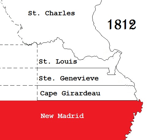
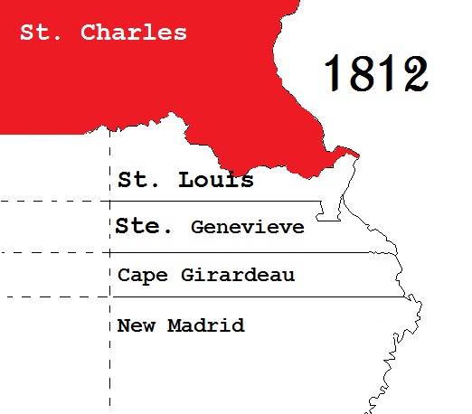
| Missouri's Five Original Counties Formed in 1812 |
|
| Cape Girardeau County |
Jackson |
Founded in 1793
Formed as a
Missouri County
in 1812 |
One of the five original counties |
Official County Web Site (Clerk) - Archives Center -
Genealogy Soc Library - Message Boards
#1 - #2 Email Group -
E-Group Archives
Research Sites #1 - #2 - #3 - First Census Courthouse burned in 1860 & 1896
|
GenWeb
GenWeb Archives
|
 |
 |
| New Madrid County |
New Madrid |
Founded on
Formed as a
Missouri County
in 1812 |
One of the five original counties |
Courthouse Address - New Madrid City Site - Library -
Genealogy Soc - None, Historical Socs - None
Message Boards #1 - #2- Email Group - E-Group Archives - First Census
Research Sites #1 - #2 - #3 - #4 |
GenWeb
GenWeb Archives
|
 |
 |
| Saint Charles County |
Saint Charles |
Founded in 1793
Formed as a
Missouri County
in 1812 |
One of the five original counties |
Official County Site (Clerk, Collector - , Recorder(Deeds)
Genealogy Soc -
Historical SocsCounty Soc - Directory
Library
Message Boards #1 - #2
Email Group - E-Group Archives
First Census - Research Sites #1 - #2 - #3 - #4 |
GenWeb
GenWeb Archives
|
 |
 |
| Sainte Genevieve County |
Ste Genevieve |
Founded in 1759
Formed as a
Missouri County
in 1812 |
One of the five original counties |
Official County site Courthouse Address
Genealogy & Historical Soc Address - Library
Message Boards #1 - #2 Email Group - E-Group Archives First Census -
Research Sites #1 - #2 - #3 - #4 |
GenWeb
GenWeb Archives
|  |
 |
| Saint Louis County |
Clayton |
Founded in 1764
Formed as a
Missouri County
in 1812 |
One of the five original counties |
Official County Site (Clerk, Collector - , Probate - , Recorder ) Library
Genealogy Soc - Historical Socs -
Message Boards #1 - #2 Email Group - E-Group Archives -
First Census - Research Sites #1 - #2 - #3
- #4 |
GenWeb
GenWeb Archives
|  |
 |
|
| Counties Formed from 1813 through 1820 |
|
| Washington County |
Potosi |
1813 |
Ste. Genevieve County |
Courthouse Address
Historical Socs - Genealogy Soc - None Found -
Message Boards #1 - #2 - Email Group - E-Group Archives - Library -
First Census - Research Sites #1 - #2 - #3 - #4 |
GenWeb
GenWeb Archives
|  |
 |
|
| Howard County |
Fayette |
1816 |
St. Charles
and
St. Louis
counties |
Courthouse Address
Plat Book - Library
Message Boards #1 - #2 Email Group - E-Group Archives - First Census
- Research Sites #1 - #2 - #3 - #4 |
GenWeb
GenWeb Archives
|  |
 |
|
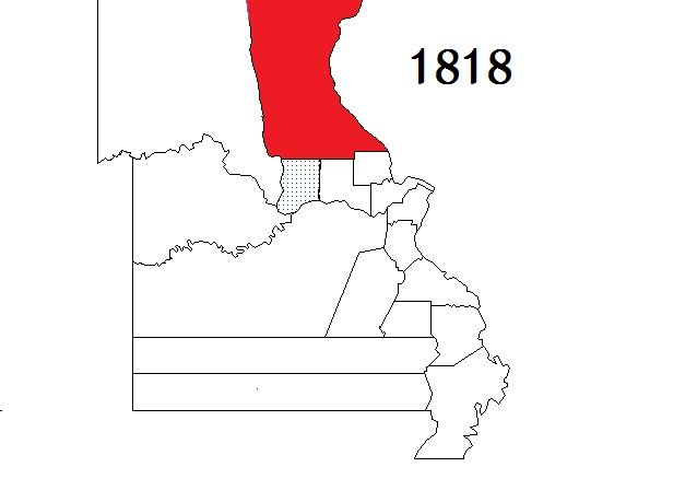
| Cooper County |
Boonville |
1818 |
Howard County |
Official County Site (Clerk, Collector - , Recorder )
Historical Socs -
Library
Message Boards #1 - #2
Email Group - E-Group Archives
First Census - Research Sites #1 - #2 - #3 - #4 |
GenWeb
GenWeb Archives
|  |
 |
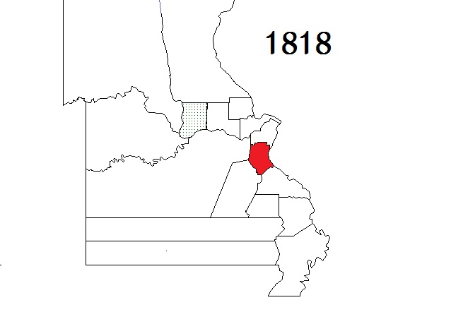
| Franklin County |
Union |
1818 |
St. Louis County |
Official County Site (Clerk, Collector - , Recorder )
Genealogy Soc None Found- Historical Soc - Library
Message Boards #1 - #2 Email Group - E-Group Archives
First Census - Research Sites #1 - #2 - #3 - #4 |
GenWeb
GenWeb Archives
|
 |
 |
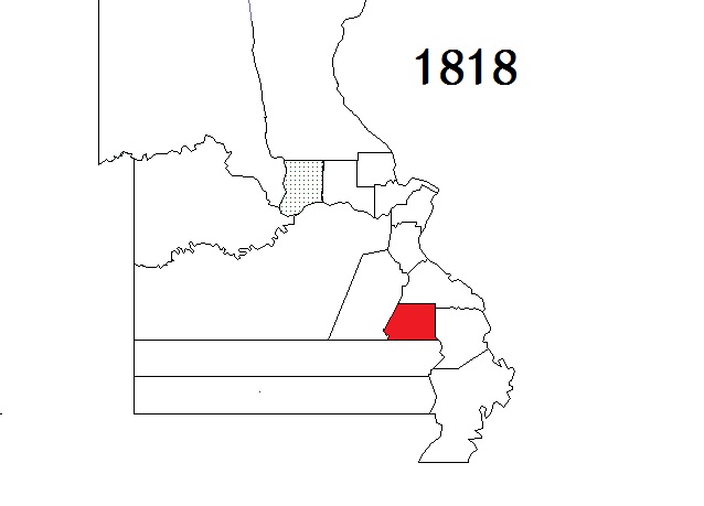
| Jefferson County |
Hillsboro |
1818 |
St. Louis and Sainte Genevieve counties |
Official County Site (Clerk, Collector - , Recorder )
Genealogy Soc - Historical Socs - Library
Message Boards #1 - #2 Email Group - E-Group Archives
First Census - Research Sites #1 - #2 - #3 - #4 |
GenWeb
GenWeb Archives
|  |
 |
| Lincoln County |
Troy |
1818 |
St. Charles County |
Official County Site (Clerk, Collector - , Recorder )
Genealogy Soc - Historical Soc Address - Library
Message Boards #1 - #2 Email Group - E-Group Archives
First Census - Research Sites #1 - #2 - #3 - #4 |
GenWeb
GenWeb Archives
|  |
 |
| Madison County |
Fredericktown |
1818 |
Cape Girardeau and Sainte Genevieve counties |
Courthouse address
Historical Soc - Soc addresses - Library
Message Boards #1 - #2 Email Group - E-Group Archives - Research Sites #1 - #2 - #3 - #4
First Census |
GenWeb
GenWeb Archives
|
 |
 |
| Montgomery County |
Montgomery City |
1818 |
St. Charles County |
Official County Site
Genealogy Soc - Historical Socs - Library - First Census -
Message Boards #1 - #2 Email Group - E-Group Archives
Research Sites #1 - #2 - #3 - #4 |
GenWeb
GenWeb Archives
|
 |
 |
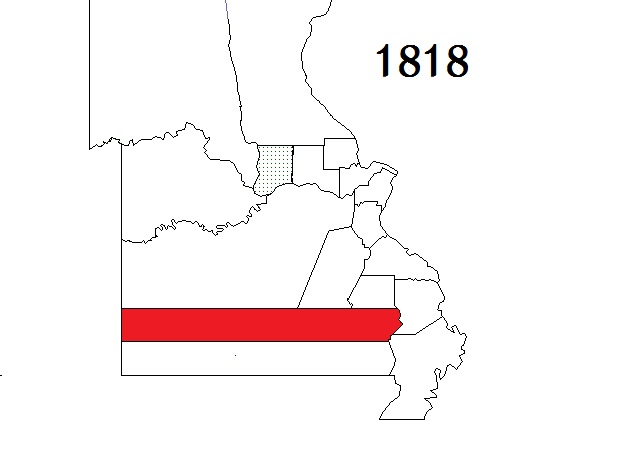
| Pike County |
Bowling Green |
1818 |
St. Charles County |
Official County Site (Clerk, Collector - , Recorder )
Genealogy Soc - Historical Socs - Library - First Census
Message Boards #1 - #2 Email Group - E-Group Archives
Research Sites #1 - #2 - #3 - #4 |
GenWeb
GenWeb Archives
|  |
 |
| Wayne County |
Greenville |
1818 |
Parts of
Cape Girardeau
and "old" Lawrence
(an extinct County) |
Courthouse Address (Clerk, Collector - , Recorder )
Genealogy Soc, none listed - Historical Soc #1 - #2 Library
Message Boards #1 - #2 Email Group - E-Group Archives
Research Sites #1 - #2 - #3 - #4 - First Census |
GenWeb
GenWeb Archives
|  |
 |
|
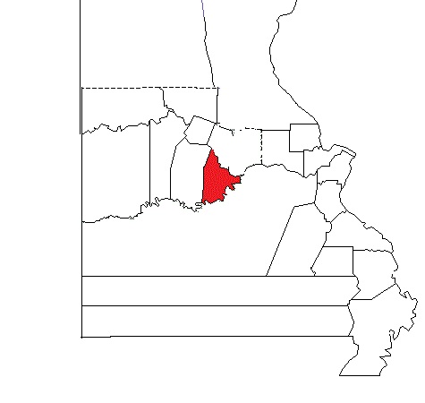
| Cole County |
Jefferson City |
1820 |
Cooper County |
Official County Site (Clerk, Collector - , Recorder )
Genealogy Soc None Listed - Historical Soc - Library
Message Boards #1 - #2 Email Group - - E-Group Archives
Jeff City E-Group Archives
Research Sites #1 - #2 - #3 - #4 - First Census |
GenWeb
GenWeb Archives
|  |
 |
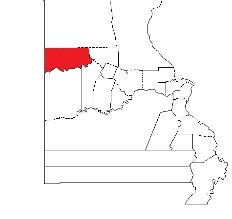
| Ray County |
Richmond |
1820 |
Howard County |
unOfficial County Site
Genealogy Soc - Historical Socs
Message Boards #1 - #2 Email Group - E-Group Archives
Research Sites #1 - #2 - #3 - #4 - First Census - Library |
GenWeb
GenWeb Archives
|  |
 |
| Saline County |
Marshall |
1820 |
Cooper County |
Courthouse Directory & Addresses
Genealogy Soc - Historical Socs - Libraries
Message Boards #1 - #2 Email Group - E-Group Archives
Research Sites #1 - #2 - #3 - #4 - First Census Courthouse burned in 1864 |
GenWeb
GenWeb Archives
|  |
 |
|
| Counties Formed from 1821 through 1830 |
|
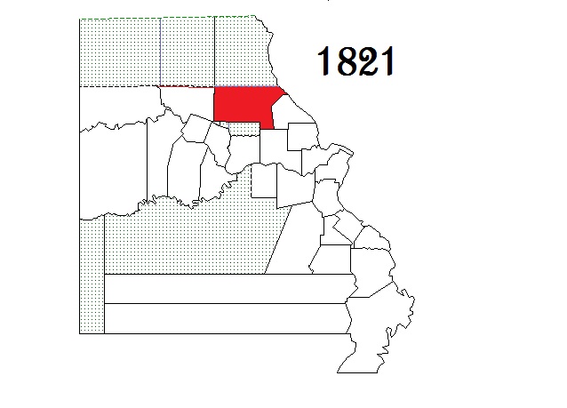
| Boone County |
Columbia |
1821 |
Howard County |
Official County Site (Clerk, Collector - , Recorder )
Genealogy Soc - Historical Socs - Library
Message Boards #1 - #2 Email Group - E-Group Archives
Research Sites #1 - #2 - #3 - #4 - First Census |
GenWeb
GenWeb Archives
|  |
 |
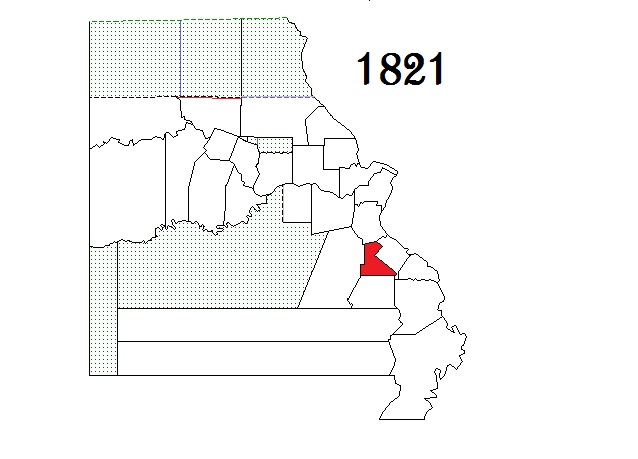
| Callaway County |
Fulton |
1821 |
Boone, Howard and Montgomery counties |
Official County Site (Clerk, Collector - , Recorder )
Genealogy Soc - Historical Socs
Message Boards #1 - #2 Email Group - E-Group Archives
Research Sites #1 - #2 - #3 - #4
- First Census - Library |
GenWeb
GenWeb Archives
|  |
 |
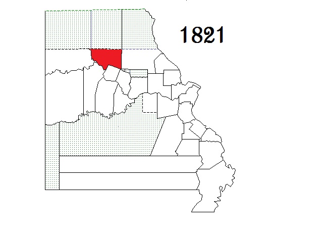
| Chariton County |
Keytesville |
1821 |
Howard County |
Courthouse Directory & Addresses - Historical Soc
Genealogy Soc None Listed
Message Boards #1 - #2 Email Group - E-Group Archives
Research Sites #1 - #2 - #3 - #4 - First Census - Library Courthouse fires in 1861, 1864 & 1973 |
GenWeb
GenWeb Archives
|  |
 |
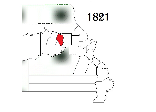
| Gasconade County |
Hermann |
1821 |
Franklin County |
Official County Site - Courthouse Directory
- Historical Socs
Message Boards #1 - #2 Email Group - E-Group Archives
Research Sites #1 - #2 - #3 - #4 - First Census - Library |
GenWeb
GenWeb Archives
|  |
 |
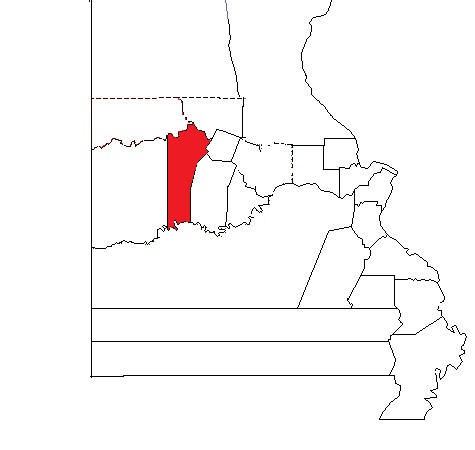
Lillard County
renamed
Lafayette County |
Lexington |
Formed as LILLARD in 1821
renamed Lafayette in 1825 |
Cooper County |
Official County Site (Clerk, Collector - , Recorder) - First Census - Libraries
Genealogy Soc - Historical Socs
Email Group - E-Group Archives
Research Sites #1 - #2 - #3 - #4 Message Boards #1 - #2 |
GenWeb
GenWeb Archives
|  |
 |
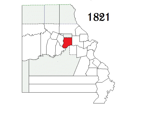
| Perry County |
Perryville |
1821 |
Sainte Genevieve County |
Official County Site (Clerk, Collector - , Recorder )
Genealogy Soc - Historical Socs - Library
Message Boards #1 - #2 Email Group - E-Group Archives
First Census - Research Sites #1 - #2 - #3 - #4 |
GenWeb
GenWeb Archives
|  |
 |
| Ralls County |
New London |
1821 |
Pike County |
Corn Officials Directory (Clerk) - Library
Genealogy Soc None Listed - Historical Socs -
Message Boards #1 - #2 Email Group - E-Group Archives
First Census - Research Sites #1 - #2 - #3 - #4 |
GenWeb
GenWeb Archives
|  |
 |
| Saint Francois County |
Farmington |
1821 |
Jefferson, Ste Genevieve and Washington counties |
Official County Site (Clerk, Collector - , Recorder )
Genealogy Soc None Found - Historical Socs - Library
Message Boards #1 - #2 Email Group - E-Group Archives
First Census - Research Sites #1 - #2 - #3 - #4 |
GenWeb
GenWeb Archives
|  |
 |
|
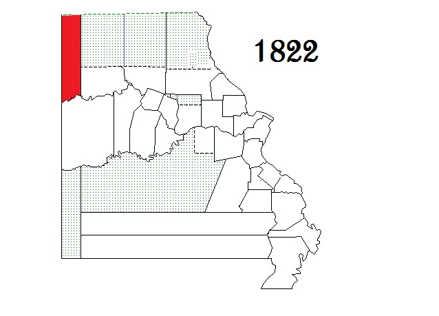
| Clay County |
Liberty |
1822 |
Ray County |
Official County Site (Clerk, Collector - , Recorder)
Genealogy Soc - Historical Socs - Library
Message Boards #1 - #2 Email Group - E-Group Archives
First Census - Research Sites #1 - #2 - #3 - #4 |
GenWeb
GenWeb Archives
KC GenWeb Archives
|  |
 |
| Scott County |
Benton |
1822 |
New Madrid County |
Official County Site (Clerk, Collector - , Recorder)
Genealogy Soc - Historical Socs - Library
Message Boards #1 - #2 Email Group - E-Group Archives
First Census - Research Sites #1 - #2 - #3 - #4 |
GenWeb
GenWeb Archives
|  |
 |
|
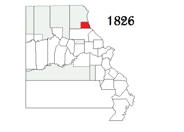
| Jackson County |
Kansas City,
Independence |
1826 |
Lillard (now Lafayette) County |
Official County Site (Clerk, Collector - , Recorder)
Genealogy Soc - Historical Socs - Library
Message Boards #1 - #2 Email Group - E-Group Archives - KC E-Group Archives
First Census - Research Sites #1 - #2 - #3 - #4 |
GenWeb
GenWeb Archives
KC GenWeb Archives
|  |
 |
| Marion County |
Palmyra |
1826 |
Ralls County |
Courthouse Directory (Clerk) Genealogy Soc None Found Historical Soc - Library
Message Boards #1 - #2 Email Group - E-Group Archives
First Census-1830 (microfilm unreadable) Research Sites #1 - #2 - #3 - #4 |
GenWeb
GenWeb Archives
|  |
 |
|
| Crawford County |
Steelville |
1829 |
Gasconade County |
Official County Site (Clerk, Collector - , Recorder )
Genealogy Soc - Historical Socs - Library
Message Boards #1 - #2 Email Group - E-Group Archives
First Census - Research Sites #1 - #2 - #3 - #4 Courthouse burned in 1873 & 1884 |
GenWeb
GenWeb Archives
|  |
 |
| Randolph County |
Huntsville |
1829 |
Chariton and Ralls counties |
Official County Site (Clerk, Collector - , Recorder)
Genealogy Soc - Historical Socs - Library
Message Boards #1 - #2 Email Group - E-Group Archives
First Census - Research Sites #1 - #2 - #3 - #4 Courthouse burned in 1882, deed index to 1829 survived. |
GenWeb
GenWeb Archives
|  |
 |
|
| Counties Formed from 1831 through 1840 |
|
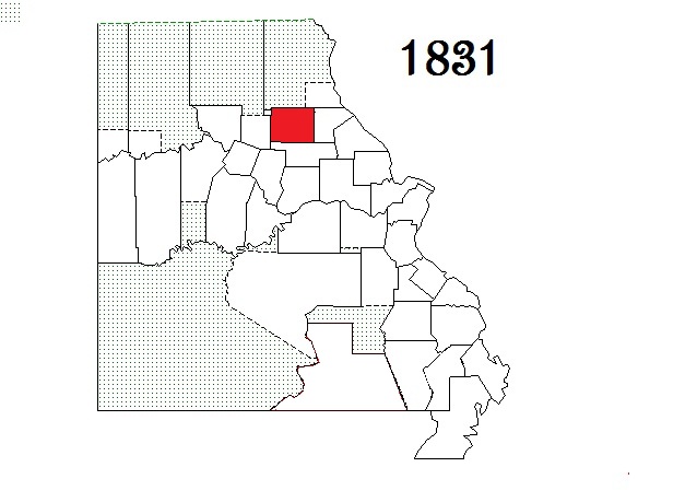
| Audrain County |
Mexico |
1831 |
Callaway, Monroe and Ralls counties |
Official County Site (Clerk, Collector - , Recorder )
Genealogy Soc - Historical Soc - Library
Message Boards #1 - #2 Email Group - E-Group Archives -
First Census - Research Sites #1 - #2 - #3 - #4 |
GenWeb
GenWeb Archives
|  |
 |
| Monroe County |
Paris |
1831 |
Ralls County |
Official County Site (Clerk, Collector - , Recorder - Probate Court )
Genealogy Soc None Listed- Historical Soc - Library
Message Boards #1 - #2 Email Group - E-Group Archives
First Census - Research Sites #1 - #2 - #3 - #4 |
GenWeb
GenWeb Archives
|  |
 |
| Ripley County |
Doniphan |
1831 |
Wayne County |
Official County Site - Courthouse Directory -
Genealogy Soc - Historical Socs - Library
Message Boards #1 - #2 Email Group - E-Group Archives
First Census - Research Sites #1 - #2 - #3 - #4 Courthouse burned in Civil War & 1898 |
GenWeb
GenWeb Archives
|  |
 |
|
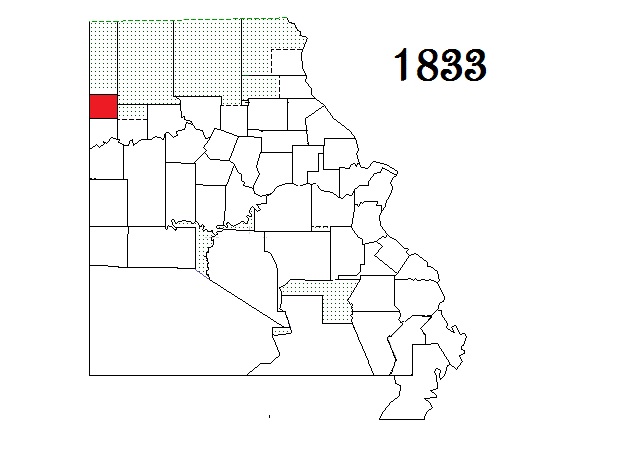
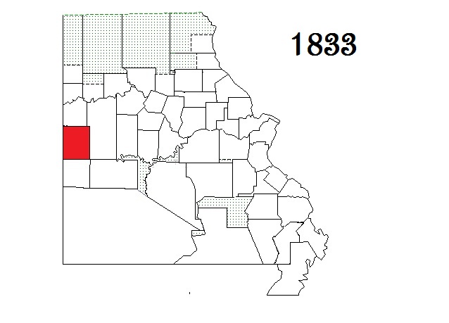
| Carroll County |
Carrollton |
1833 |
Ray County |
Courthouse Directory
Genealogy Soc - Historical Socs - Library
Message Boards #1 - #2 Email Group - E-Group Archives
First Census - Research Sites #1 - #2 - #3 - #4 |
GenWeb
GenWeb Archives
|  |
 |
| Clinton County |
Plattsburg |
1833 |
Clay County |
Courthouse Directory - Genealogy Soc - Historical Socs - Library
Message Boards #1 - #2 Email Group - E-Group Archives
First Census - Research Sites #1 - #2 - #3 - #4 |
GenWeb
GenWeb Archives |
 |
 |
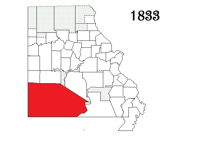
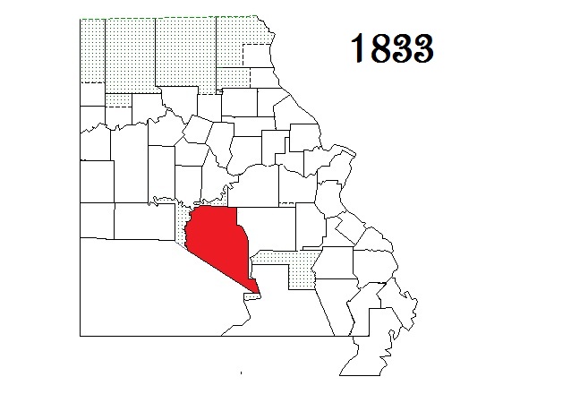
| Greene County |
Springfield |
1833 |
Crawford and Wayne counties |
Official County Site (Clerk, Collector - , Recorder )
Genealogy Soc - Historical Socs - Library
Message Boards #1 - #2 Email Group - E-Group Archives
First Census - Research Sites #1 - #2 - #3 - #4 Courthouse burned in 1861 |
GenWeb
GenWeb Archives
|  |
 |
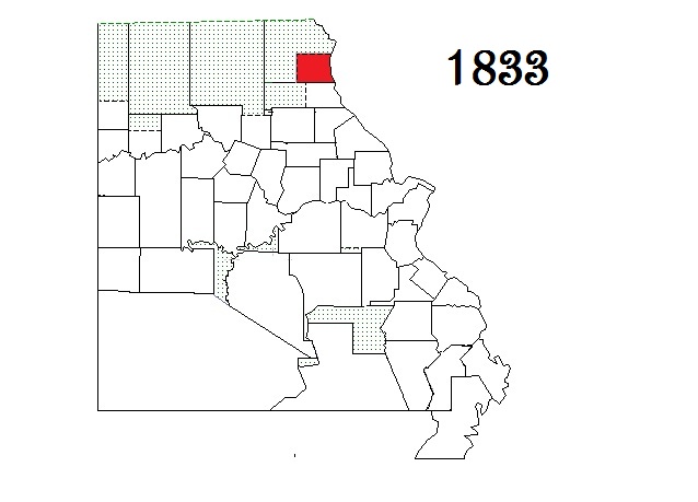
| Lewis County |
Monticello |
1833 |
Marion County |
Courthouse directory
Genealogy Soc - Historical Socs - Library
Message Boards #1 - #2 Email Group - E-Group Archives
First Census - Research Sites #1 - #2 - #3 - #4 |
GenWeb
GenWeb Archives
|  |
 |
| Morgan County |
Versailles |
1833 |
Cooper County |
Official County Site (Clerk, Collector - , Recorder )
Genealogy Soc - Historical Soc - Library
Message Boards #1 - #2 Email Group - E-Group Archives
First Census - Research Sites #1 - #2 - #3 - #4 Courthouse burned in 1887 |
GenWeb
GenWeb Archives
|  |
 |
| Pettis County |
Sedalia |
1833 |
Cooper and Saline counties |
Official County Site (Clerk, Collector - , Recorder )
Genealogy Soc -None Listed - Historical Socs - Library
Message Boards #1 - #2 Email Group - E-Group Archives
First Census - Research Sites #1 - #2 - #3 - #4 |
GenWeb
GenWeb Archives
|  |
 |
| Pulaski County |
Waynesville |
1833 |
Crawford County |
Official County Site Courthouse Directory - Collector -
Genealogy Soc - Historical Socs - Library
Message Boards #1 - #2 Email Group - E-Group Archives
First Census - Research Sites #1 - #2 - #3 - #4 Courthouse burned in 1903 |
GenWeb
GenWeb Archives
|  |
 |
| Warren County |
Warrenton |
1833 |
Montgomery County |
Official County Site - Courthouse Directory - Collector -
Genealogy Soc - None Found - Historical Socs - Library
Message Boards #1 - #2 Email Group - E-Group Archives
First Census - Research Sites #1 - #2 - #3 - #4 |
GenWeb
GenWeb Archives
|  |
 |
|
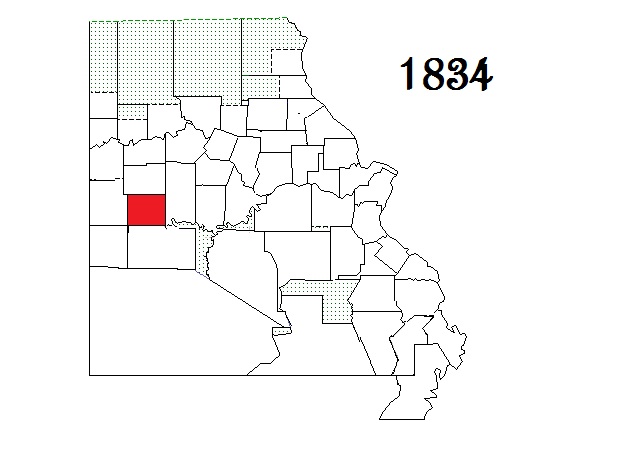
| Johnson County |
Warrensburg |
1834 |
Lillard (now Lafayette) County |
Official County Site (Clerk, Collector - , Recorder )
Genealogy Soc - Historical Socs - Library
Message Boards #1 - #2 Email Group - E-Group Archives
First Census - Research Sites #1 - #2 - #3 - #4 |
GenWeb
GenWeb Archives
|
 |
 |
Rives County
(Henry Co) |
Clinton |
Formed as Rives in 1834
renamed Henry in 1841 |
Lillard (now Lafayette) County |
Official County Site (Clerk, Collector - Recorder)
Genealogy Soc - Historical Socs - Library
Message Boards #1 - #2 Email Group - E-Group Archives
First Census - Research Sites #1 - #2 - #3 - #4 |
GenWeb
GenWeb Archives
|
 |
 |
|
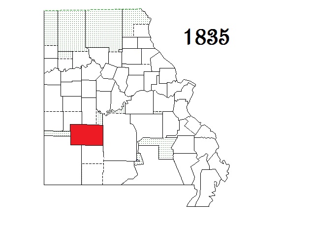
| Barry County |
Cassville |
1835 |
Greene County |
Courthouse Directory - Recorder
Genealogy Soc - Historical Socs - Library
Message Boards #1 - #2 Email Group - E-Group Archives
First Census - Research Sites #1 - #2 - #3 - #4 |
GenWeb
GenWeb Archives
|  |
 |
| Benton County |
Warsaw |
1835 |
Pettis and Greene counties |
Official County Site (Clerk, Collector - , Recorder )
Genealogy Soc - None Found - Historical Socs - Library
Message Boards #1 - #2 Email Group - E-Group Archives
First Census - Research Sites #1 - #2 - #3 - #4 |
GenWeb
GenWeb Archives
|
 |
 |
| Polk County |
Bolivar |
1835 |
Greene County |
Courthouse Directory -
Genealogy Soc - Historical Soc - Library
Message Boards #1 - #2 Email Group - E-Group Archives
First Census - Research Sites #1 - #2 - #3 - #4 |
GenWeb
GenWeb Archives
|
 |
 |
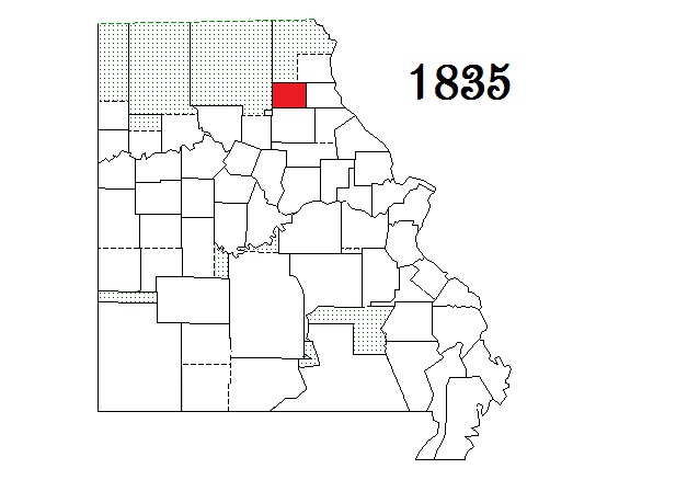
| Shelby County |
Shelbyville |
1835 |
Marion County |
Courthouse Directory - Genealogy Soc - none found Historical Socs - Library
Message Boards #1 - #2 Email Group - E-Group Archives
First Census - Research Sites #1 - #2 - #3 - #4 |
GenWeb
GenWeb Archives
|  |
 |
| Stoddard County |
Bloomfield |
1835 |
New Madrid County |
Courthouse Directory
Genealogy Soc - Historical Socs - Library
Message Boards #1 - #2 Email Group - E-Group Archives
First Census - Research Sites #1 - #2 - #3 - #4 |
GenWeb
GenWeb Archives
|  |
 |
VanBuren County
(Renamed Cass) |
Harrisonville |
Formed as Van Buren County in 1835
Renamed Cass County in 1849 |
Jackson County |
Official County Site (Clerk, Collector - , Recorder )
Genealogy Soc - Historical Socs - Library
Message Boards #1 - #2 Email Group - E-Group Archives
First Census - Research Sites #1 - #2 - #3 - #4 |
GenWeb
GenWeb Archives
|  |
 |
|
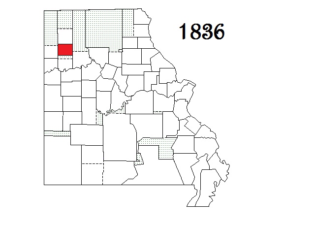
| Caldwell County |
Kingston |
1836 |
Ray County |
Official County Site - Courthouse Directory
Genealogy Soc address - Historical Socs - Library
Message Boards #1 - #2 Email Group - E-Group Archives
First Census - Research Sites #1 - #2 - #3 - #4 - #5 Courthouse burned in 1860 & 1896 |
GenWeb
GenWeb Archives
|  |
 |
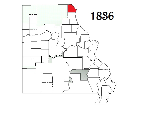
| Clark County |
Kahoka |
1836 |
Lewis County |
Courthouse Directory (Clerk, Collector - , Recorder )
Genealogy Soc - None Found Historical Socs - Library
Message Boards #1 - #2 Email Group - E-Group Archives
First Census - Research Sites #1 - #2 - #3 - #4 |
GenWeb
GenWeb Archives
|  |
 |
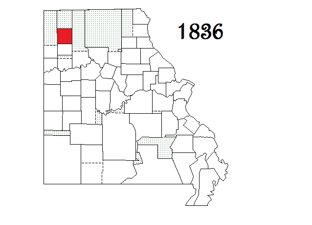
| Daviess County |
Gallatin |
1836 |
Ray County |
Courthouse Directory -
Genealogy Soc - Historical Socs - Library
Message Boards #1 - #2 Email Group - E-Group Archives
First Census - Research Sites #1 - #2 - #3 - #4 - #5 |
GenWeb
GenWeb Archives
|  |
 |
|
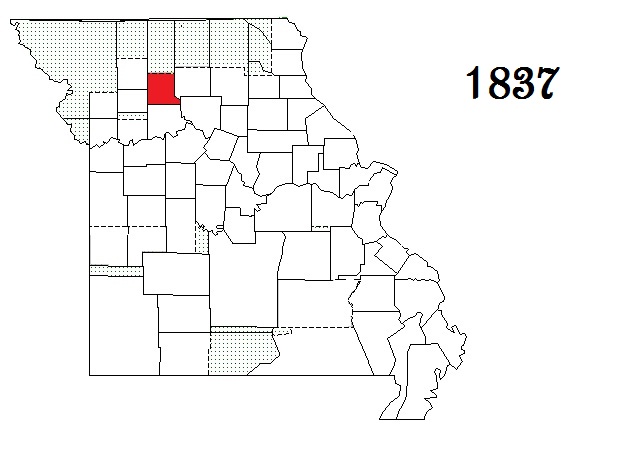
| Linn County |
Linneus |
1837 |
Chariton County |
Courthouse Directory -
Genealogy Soc - Historical Socs - Library
Message Boards #1 - #2 Email Group - E-Group Archives
First Census - Research Sites #1 - #2 - #3 - #4 |
GenWeb
GenWeb Archives
|  |
 |
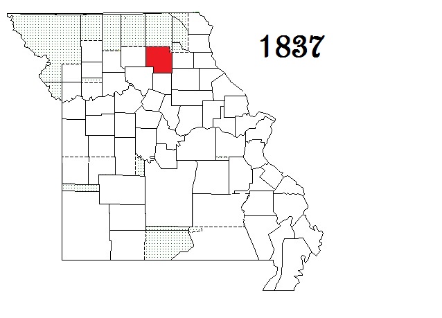
| Livingston County |
Chillicothe |
1837 |
Carroll County |
Official County Site - Directory of Officials -
Genealogy Soc - Historical Socs - Library
Message Boards #1 - #2 Email Group - E-Group Archives
First Census - Research Sites #1 - #2 - #3 - #4 - #5 |
GenWeb
GenWeb Archives
|  |
 |
| Macon County |
Macon |
1837 |
Chariton and Randolph counties |
Official County Site (Clerk, Collector - , Recorder, - Probate Court)
Genealogy Soc - None Found - Historical Socs - Library
Message Boards #1 - #2 Email Group - E-Group Archives
First Census - Research Sites #1 - #2 - #3 - #4 |
GenWeb
GenWeb Archives
|  |
 |
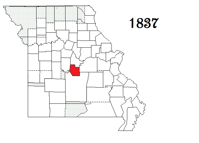
| Miller County |
Tuscumbia |
1837 |
Cole and Pulaski counties |
Official County Site (Clerk, Collector - , Recorder )
Genealogy Soc - Historical Socs - Library
Message Boards #1 - #2 Email Group - E-Group Archives
First Census - Research Sites #1 - #2 - #3 - #4 |
GenWeb
GenWeb Archives
|
 |
 |
| Shannon County |
Eminence |
1837 |
Ripley County |
Courthouse Directory -
Genealogy Soc - Historical Socs - Library
Message Boards #1 - #2 Email Group - E-Group Archives
First Census (1850, no 1840 found) - Research Sites #1 - #2 - #3 - #4 Courthouse burned in 1863, 1871, 1895 & 1938 |
GenWeb
GenWeb Archives
|  |
 |
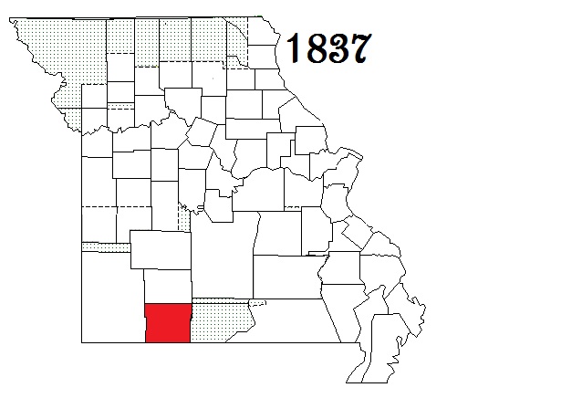
| Taney County |
Forsyth |
1837 |
Greene County |
Official County Site (Clerk, Collector - , Recorder )
Genealogy Soc - none found - Historical Socs - Library
Message Boards #1 - #2 Email Group - E-Group Archives
First Census - Research Sites #1 - #2 - #3 - #4 Courthouse burned in 1863 & 1885 |
GenWeb
GenWeb Archives
|  |
 |
|
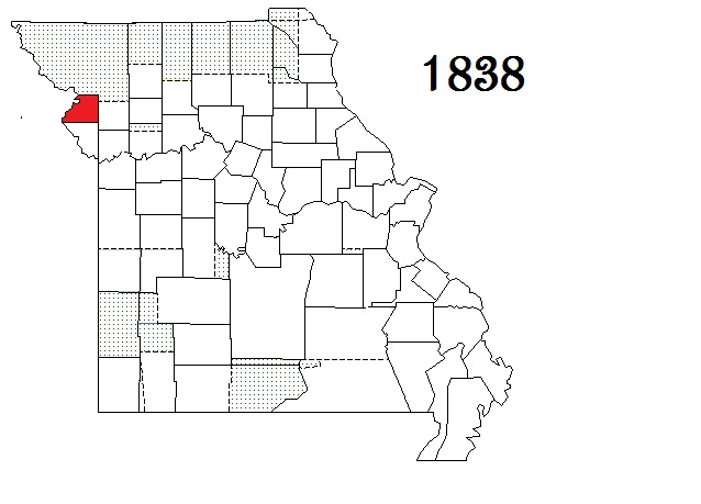
| Buchanan County |
Saint Joseph |
1838 |
Part of the Platte Purchase |
Official County Site (Clerk, Collector - , Recorder )
Genealogy Soc - Historical Socs - Library
Message Boards #1 - #2 Email Group - E-Group Archives
First Census - Research Sites #1 - #2 - #3 - #4 |
GenWeb
GenWeb Archives
|  |
 |
| Newton County |
Neosho |
1838 |
Barry County |
Official County Tourism Site - Courthouse Directory (Collector - , Recorder )
Genealogy Soc - None Found Historical Socs - Library
Message Boards #1 - #2 Email Group - E-Group Archives
First Census - Research Sites #1 - #2 - #3 - #4 Courthouse burned in 1862 |
GenWeb
GenWeb Archives
|  |
 |
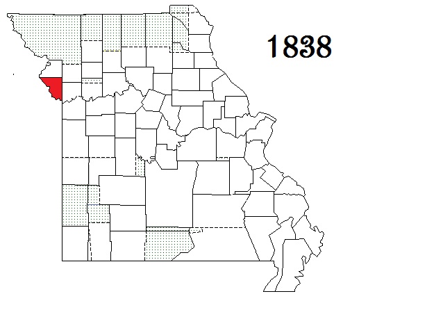
| Platte County |
Platte City |
1838 |
Part of the Platte Purchase |
Official County Site (Clerk, Collector - , Recorder)
Genealogy Soc - Historical Socs - Library
Message Boards #1 - #2 Email Group - E-Group Archives
First Census - Research Sites #1 - #2 - #3 - #4 |
GenWeb
GenWeb Archives
|  |
 |
|
| Grundy County |
Trenton |
Conflicting sources one say 1839 the other says 1841 |
Livingston County |
Official County Site (Clerk, Collector - , Recorder)
Genealogy Soc - Historical Socs - Library
Message Boards #1 - #2 Email Group - E-Group Archives
First Census (formed too late, for 1840 see Livingston) - Research Sites #1 - #2 - #3 - #4 |
GenWeb
GenWeb Archives
|  |
 |
|
| Counties Formed from 1841 through 1850 |
|
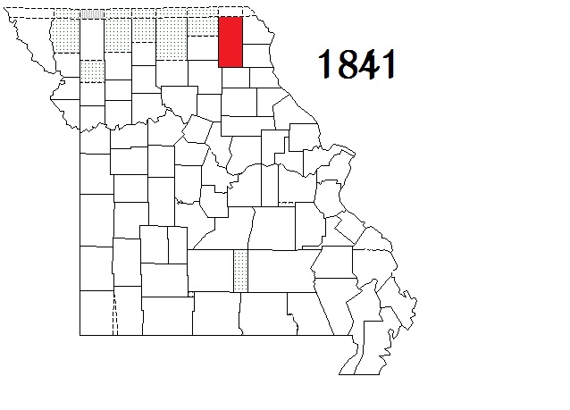
| Adair County |
Kirksville |
1841 |
Macon County |
Courthouse Directory -
Genealogy Soc - None found Historical Socs - Library
Message Boards #1 - #2 Email Group - E-Group Archives - Kirksville E-Group Archives -
First Census - Research Sites #1 - #2 - #3 - #4 |
GenWeb
GenWeb Archives
|  |
 |
| Andrew County |
Savannah |
1841 |
Part of the Platte Purchase |
Official County Site (Clerk, Collector - , Recorder )
Genealogy Soc - None Found - Historical Socs - Library
Message Boards #1 - #2 Email Group - E-Group Archives
First Census - Research Sites #1 - #2 - #3 - #4 |
GenWeb
GenWeb Archives
|  |
 |
| Bates County |
Butler |
1841 |
Van Buren (now Cass |
Official County Site (Clerk, Recorder )
Genealogy Soc - None Found - Historical Socs - Library
Message Boards #1 - #2 Email Group - E-Group Archives
First Census - Research Sites #1 - #2 - #3 - #4 County Courthouse burned in 1861, some records lost |
GenWeb
GenWeb Archives
|  |
 |
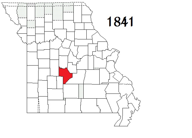
| Camden County |
Camdenton |
Formed as Kinderhook in 1841, renamed Camden in 1843 |
Benton, Morgan and Pulaski counties |
Official County Site (Clerk, Collector - , Recorder )
Genealogy Soc - Historical Socs - Library
Message Boards #1 - #2 Email Group - E-Group Archives
First Census - Research Sites #1 - #2 - #3 - #4 |
GenWeb
GenWeb Archives
|  |
 |
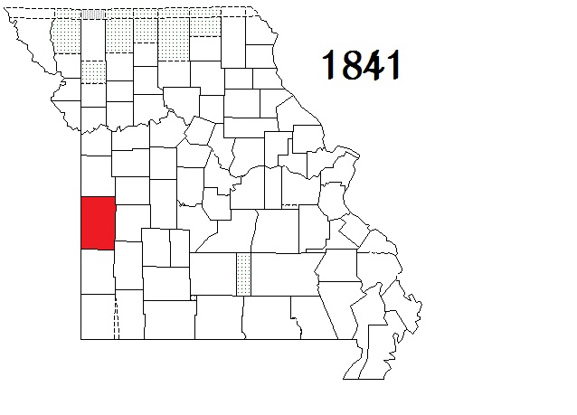
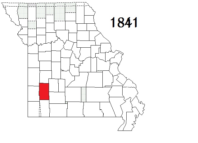
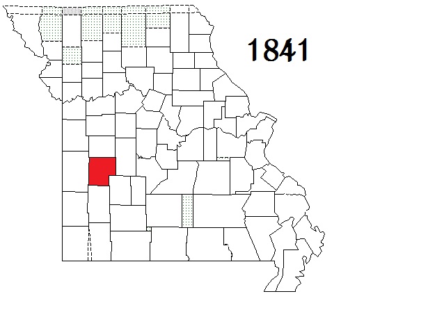
| Dade County |
Greenfield |
1841 |
Barry and Polk counties |
Courthouse Directory -
Genealogy Soc - Historical Socs - Library
Message Boards #1 - #2 Email Group - E-Group Archives
First Census - Research Sites #1 - #2 - #3 - #4 Courthouse burned in 1863 |
GenWeb
GenWeb Archives
|  |
 |
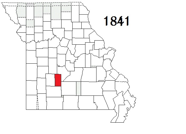
| Dallas County |
Buffalo |
Organized & named Niangua in 1841 renamed Dallas in 1843 |
Polk County |
Courthouse Directory -
Genealogy Soc - None Found - Historical Socs - Library
Message Boards #1 - #2 Email Group - E-Group Archives
First Census - Research Sites #1 - #2 - #3 - #4 Courthouse burned in 1863, 1864 & 1867 |
GenWeb
GenWeb
|  |
 |
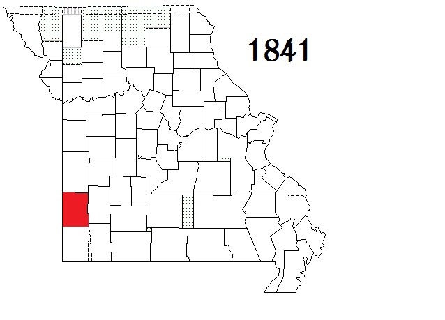
| Gentry County |
Albany |
1841 |
Clinton County |
Courthouse directory -
Genealogy Soc - Historical Socs - Library
Message Boards #1 - #2 Email Group - E-Group Archives
First Census - Research Sites #1 - #2 - #3 - #4 Courthouse blown down in a wind storm in 1883, some records lost |
GenWeb
GenWeb Archives
|
 |
 |
(Rives Co.)
renamed
Henry Co |
Clinton |
Formed as Rives in 1834
renamed Henry in 1841 |
Lillard (now Lafayette) County |
Official County Site (Clerk, Collector - Recorder)
Genealogy Soc - Historical Socs - Library
Message Boards #1 - #2 Email Group - E-Group Archives
First Census - Research Sites #1 - #2 - #3 - #4 |
GenWeb
GenWeb Archives
|
|
|
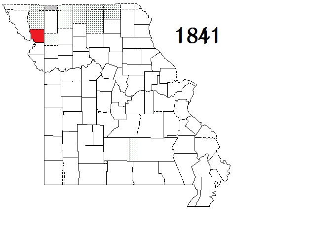
| Holt County |
Oregon |
1841 |
Part of the Platte Purchase |
Courthouse Directory -
Genealogy Soc - None found Historical Socs - Library
Message Boards #1 - #2 Email Group - E-Group Archives
First Census - Research Sites #1 - #2 - #3 - #4 |
GenWeb
GenWeb Archives
|  |
 |
| Jasper County |
Carthage |
1841 |
Barry County |
Official County Site (Clerk, Collector - , Recorder )
Genealogy Soc - Historical Socs - Libraries
Message Boards #1 - #2 Email Group - E-Group Archives
First Census - Research Sites #1 - #2 - #3 - #4 |
GenWeb
GenWeb Archives
|  |
 |
| Oregon County |
Alton |
1841 |
Ripley County |
Courthouse Directory -
Genealogy Soc - Historical Socs - Library
Message Boards #1 - #2 Email Group - E-Group Archives
First Census - Research Sites #1 - #2 - #3 - #4 Courthouse burned in 1863 |
GenWeb
GenWeb Archives
|  |
 |
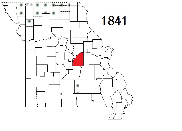
| Osage County |
Linn |
1841 |
Gasconade County |
Official County Site (Clerk, Collector - , Recorder )
Genealogy Soc - Historical Socs - Library
Message Boards #1 - #2 Email Group - E-Group Archives
First Census - Research Sites #1 - #2 - #3 - #4 Courthouse burned in 1880 and 1922 |
GenWeb
GenWeb Archives
|  |
 |
| Ozark County |
Gainesville |
1841 Formed as Ozark, 1843 renamed Decatur, 1845 re-renamed Ozark |
Taney County |
County Site - Courthouse Directory -
Genealogy Soc - Historical Socs - Library
Message Boards #1 - #2 Email Group - E-Group Archives
First Census - Research Sites #1 - #2 - #3 - #4 Courthouse burned in 1858/9, pre 1864 & 1934 |
GenWeb
GenWeb
|  |
 |
| Saint Clair County |
Osceola |
1841 |
Rives (now Henry) County |
Official County Site (Clerk, Collector - , Recorder )
Genealogy Soc - Historical Socs - Library
Message Boards #1 - #2 Email Group - E-Group Archives
First Census - Research Sites #1 - #2 - #3 - #4 Courthouse was burned in 1861 & 1864; Probate records lost |
GenWeb
GenWeb Archives
|  |
 |
| Scotland County |
Memphis |
1841 |
Clark, Lewis, and Shelby counties |
Official County Site (Clerk, Collector - , Recorder )
Genealogy Soc - Historical Socs - Library
Message Boards #1 - #2 Email Group - E-Group Archives
First Census - Research Sites #1 - #2 - #3 - #4 |
GenWeb
GenWeb Archives
|  |
 |
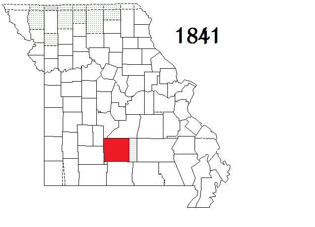
| Wright County |
Hartville |
1841 |
Pulaski County |
Official County Site (Clerk) -
Genealogy Soc - Historical Socs - Library
Message Boards #1 - #2 Email Group - E-Group Archives
First Census - Research Sites #1 - #2 - #3 - #4 Courthouse destroyed by fire in 1849, 1862, 1863, 1864, by tornado in 1888, & fire in 1897 |
GenWeb
GenWeb Archives
|  |
 |
|
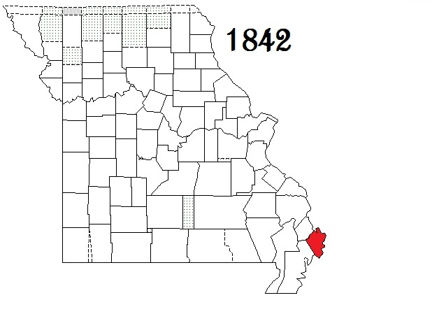
| Mississippi County |
Charleston |
1842 |
Scott County |
Official County Site (Clerk, Collector, Recorder) -
Genealogy Soc - Historical Socs - Library
Message Boards #1 - #2 Email Group - E-Group Archives
First Census - Research Sites #1 - #2 - #3 - #4 Courthouse burned in 1891 & 1997 |
GenWeb
GenWeb Archives
|  |
 |
|
| Atchison County |
Rock Port |
1843 |
Holt County, part of the Platte Purchase |
Official County Site - County Officials Directory
Genealogy Soc - None Found - Historical Socs - Library
Message Boards #1 - #2 Email Group - E-Group Archives
First Census - Research Sites #1 - #2 - #3 - #4 |
GenWeb
GenWeb Archives
|  |
 |
| DeKalb County |
Maysville |
1843 |
Clinton County |
Official County Site - Courthouse resources -
Genealogy Soc - Historical Socs - Library
Message Boards #1 - #2 Email Group - E-Group Archives
First Census - Research Sites #1 - #2 - #3 - #4 Courthouse burned in 1878 |
GenWeb
GenWeb Archives
|  |
 |
| Dunklin County |
Kennett |
1843 |
Stoddard County |
Courthouse Directory -
Genealogy Soc - None Found Historical Socs - Library
Message Boards #1 - #2 Email Group - E-Group Archives - Bootheel E-Archives
First Census - Research Sites #1 - #2 - #3 - #4 Courthouse burned in Civil War & 1872; all records destroyed |
GenWeb
GenWeb Archives
|  |
 |
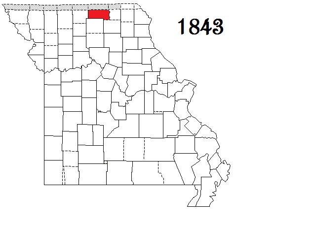
| Harrison County |
Bethany |
1843 |
Daviess County |
Official County Site ( Recorder ) -
Genealogy Soc - Historical Socs - Library
Message Boards #1 - #2 Email Group - E-Group Archives
First Census - Research Sites #1 - #2 - #3 - #4 Courthouse burned in 1874 |
GenWeb
GenWeb Archives
|  |
 |
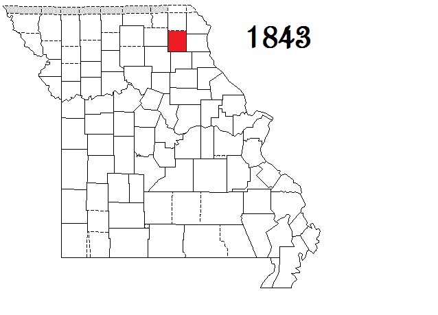
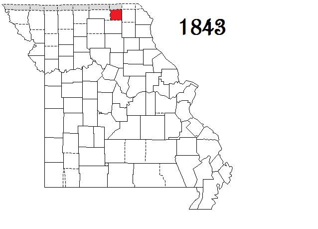
| Knox County |
Edina |
1843 |
Scotland County |
Official County Site -
Genealogy Soc - None Found - Historical Socs - Library
Message Boards #1 - #2 Email Group - E-Group Archives
First Census - Research Sites #1 - #2 - #3 - #4 Courthouse burned in 1885; no record loss |
GenWeb
GenWeb Archives
|  |
 |
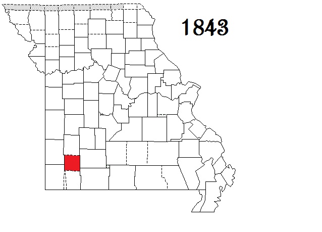
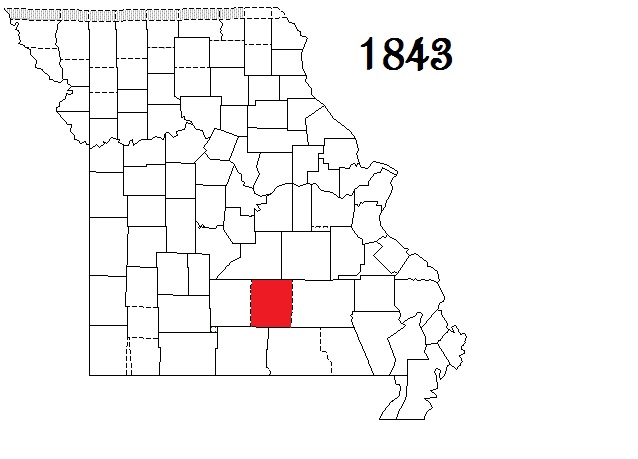
| Lawrence County |
Mount Vernon |
1843 |
Barry and Dade counties |
Courthouse directory -
Genealogy Soc - None Found Historical Socs - Library
Message Boards #1 - #2 Email Group - E-Group Archives
First Census - Research Sites #1 - #2 - #3 - #4 |
GenWeb
GenWeb Archives
|  |
 |
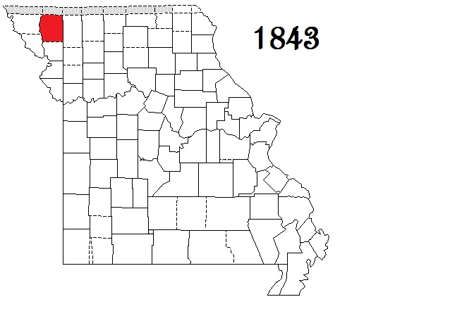
| Nodaway County |
Maryville |
1843 |
Andrew County, the Platte Purchase |
Official County Site (Clerk, Collector - , Recorder )
Genealogy Soc - Historical Socs - Library
Message Boards #1 - #2 Email Group - E-Group Archives
First Census - Research Sites #1 - #2 - #3 - #4 Courthouse burned in 1908 |
GenWeb
GenWeb Archives
|  |
 |
| Putnam County |
Unionville |
Formed 1843, consolidated with Dodge (now defunct) in 1853 |
Adair and Sullivan counties |
Official County Site - Courthouse Directory -
Genealogy Soc - Historical Socs - Library
Message Boards #1 - #2 Email Group - E-Group Archives
First Census - Research Sites #1 - #2 - #3 - #4 |
GenWeb
GenWeb Archives
|
 |
 |
| Schuyler County |
Lancaster |
1843 |
Adair County |
Courthouse address ( Collector, Recorder )
Genealogy Soc - None Found Historical Socs - Library
Message Boards #1 - #2 Email Group - E-Group Archives
First Census - Research Sites #1 - #2 - #3 - #4 |
GenWeb
GenWeb Archives
|  |
 |
| Sullivan County |
Milan |
1843 |
Linn County |
Courthouse Directory (Clerk, Collector, Recorder )
Genealogy Soc - Historical Socs - Library
Message Boards #1 - #2 Email Group - E-Group Archives
First Census - Research Sites #1 - #2 - #3 - #4 |
GenWeb
GenWeb Archives
|  |
 |
| Texas County |
Houston |
1843 |
Shannon and Wright counties |
Official County Site (Clerk, Collector, Recorder )
Genealogy Soc - Historical Socs - Library
Message Boards #1 - #2 Email Group - E-Group Archives
First Census - Research Sites #1 - #2 - #3 - #4 Courthouse burned in Civil War, 1881 & 1930 |
GenWeb
GenWeb Archives
|  |
 |
|
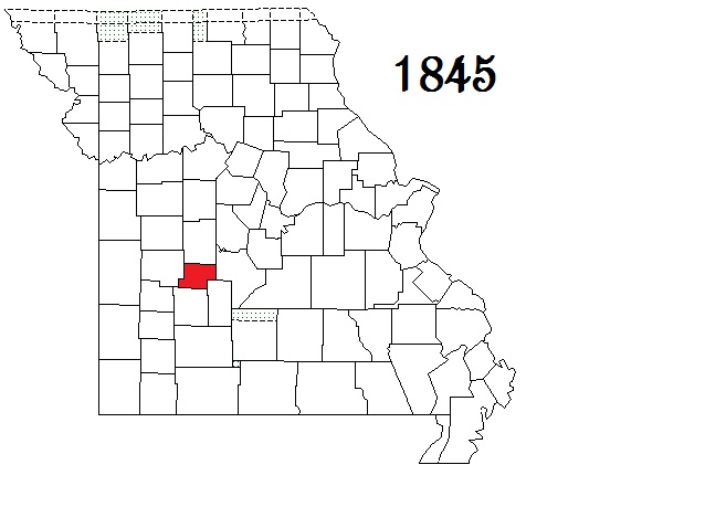
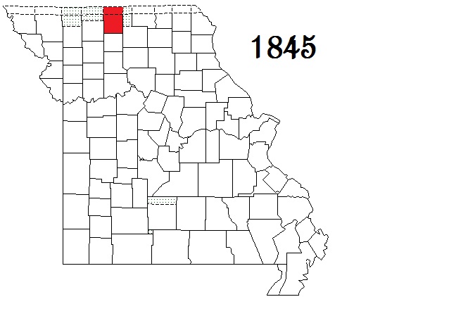
| Cedar County |
Stockton |
1845 |
Dade and St. Clair counties |
Courthouse Directory -
Genealogy Soc - Historical Socs - Library
Message Boards #1 - #2 Email Group - E-Group Archives
First Census - Research Sites #1 - #2 - #3 - #4 |
GenWeb
GenWeb Archives
|  |
 |
| Hickory County |
Hermitage |
1845 |
Benton and Polk counties |
Courthouse Directory (Collector, Recorder )
Genealogy Soc - None Found Historical Socs - Library
Message Boards #1 - #2 Email Group - E-Group Archives
First Census - Research Sites #1 - #2 - #3 - #4 Courthouse burned in 1852, 1879 & 1881 |
GenWeb
GenWeb Archives
|  |
 |
| Mercer County |
Princeton |
1845 |
Grundy County |
Courthouse Directory -
Genealogy Soc - Historical Socs - Library
Message Boards #1 - #2 Email Group - E-Group Archives
First Census - Research Sites #1 - #2 - #3 - #4 Courthouse burned in 1898; some records lost |
GenWeb
GenWeb Archives
|  |
 |
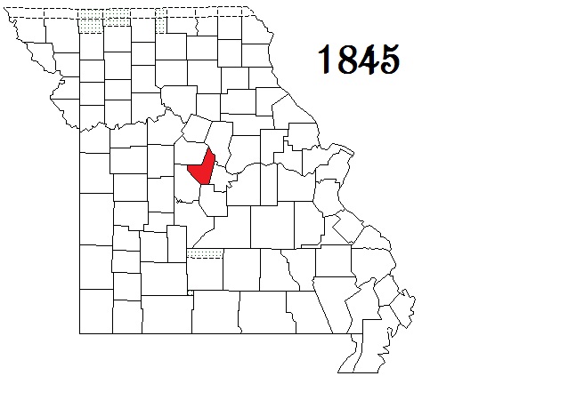
| Moniteau County |
California |
1845 |
Cole and Morgan counties |
Courthouse Directory -
Genealogy Soc - None Found - Historical Socs - Library
Message Boards #1 - #2 Email Group - E-Group Archives
First Census - Research Sites #1 - #2 - #3 - #4 |
GenWeb
GenWeb Archives
|  |
 |
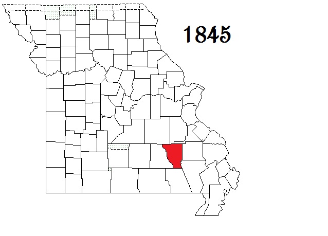
| Reynolds County |
Centerville |
1845 |
Shannon County |
Courthouse Directory -
Genealogy Soc - None Found Historical Socs - Library
Message Boards #1 - #2 Email Group - E-Group Archives
First Census - Research Sites #1 - #2 - #3 - #4 Courthouse burned in 1863 & 1867 |
GenWeb
GenWeb Archives
|  |
 |
|
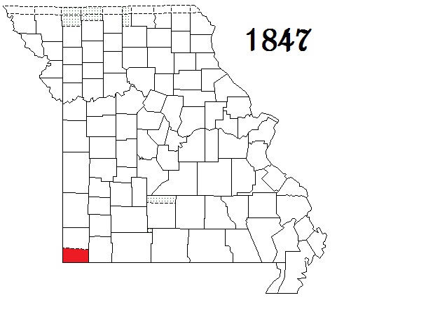
| McDonald County |
Pineville |
1847 |
Newton County |
Official County Site (Clerk, Collector - , Recorder)
Genealogy Soc - Historical Socs - Library
Message Boards #1 - #2 Email Group - E-Group Archives
First Census - Research Sites #1 - #2 - #3 - #4 Courthouse destroyed by rioters in 1856 & by fire in 1863; deeds recreated pre 1863 |
GenWeb
GenWeb Archives
|  |
 |
|
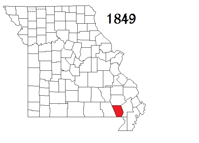
| Butler County |
Poplar Bluff |
1849 |
Wayne County |
Courthouse directory -
Genealogy Soc - Historical Socs - Library
Message Boards #1 - #2 Email Group - E-Group Archives
First Census - Research Sites #1 - #2 - #3 - #4 |
GenWeb
GenWeb Archives
|  |
 |
(VanBuren)
Cass County |
Harrisonville |
Formed as Van Buren County in 1835
Renamed Cass County in 1849 |
Jackson County |
Official County Site (Clerk, Collector - , Recorder )
Genealogy Soc - Historical Socs - Library
Message Boards #1 - #2 Email Group - E-Group Archives
First Census - Research Sites #1 - #2 - #3 - #4 |
GenWeb
GenWeb Archives
|  |
|
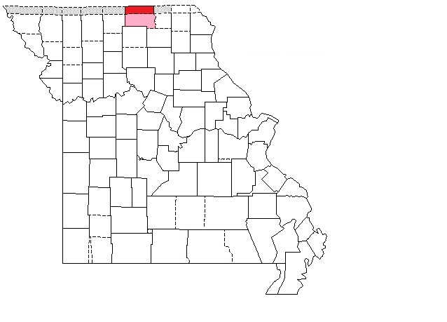
| Dodge County |
-- |
Formed in 1849 Disbanded in 1853, Combined with Putnam |
Camden, Pulaski and Wright counties |
First Census |
--
--
|
 |
---- |
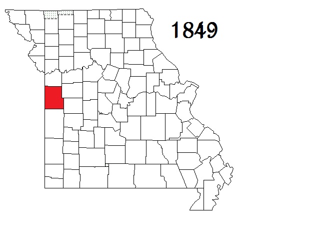
| Laclede County |
Lebanon |
1849 |
Camden, Pulaski and Wright counties |
Official County Site (Clerk, Collector - , Recorder)
Genealogy Soc - Historical Socs - Library
Message Boards #1 - #2 Email Group - E-Group Archives
First Census - Research Sites #1 - #2 - #3 - #4 |
GenWeb
GenWeb Archives
|
 |
 |
|
| Counties Formed from 1851 through 1860 |
|
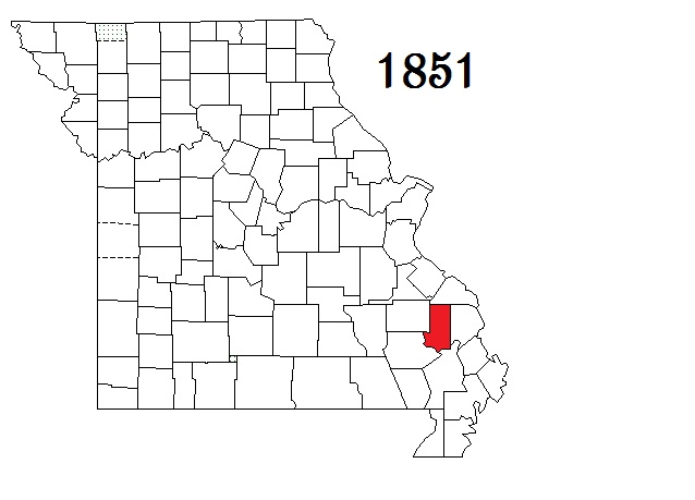
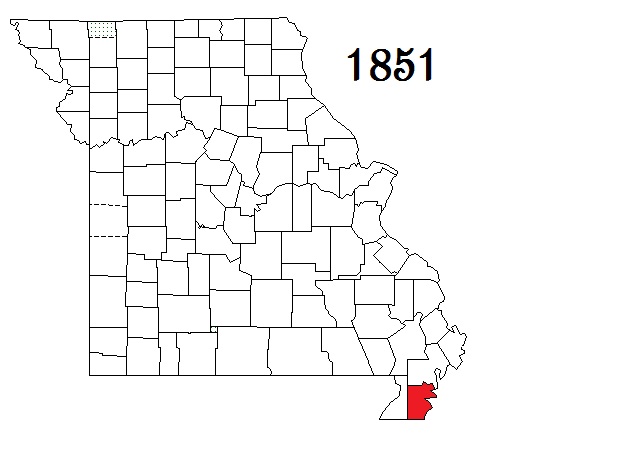
| Bollinger County |
Marble Hill |
1851 |
Cape Girardeau, Madison, Stoddard and Wayne counties |
Courthouse Directory -
Genealogy Soc - None Found Historical Socs - Library
Message Boards #1 - #2 Email Group - E-Group Archives -
First Census - Research Sites #1 - #2 - #3 - #4 Courthouse burned in 1866 & 1884 |
GenWeb
GenWeb Archives
|  |
 |
| Dent County |
Salem |
1851 |
Crawford and Shannon counties |
Official County Site (Clerk, Collector - , Recorder )
Genealogy Soc - Historical Socs - Library
Message Boards #1 - #2 Email Group - E-Group Archives -
First Census - Research Sites #1 - #2 - #3 - #4 Courthouse burned in 1864 & 1866 |
GenWeb
GenWeb Archives
|  |
 |
| Pemiscot County |
Caruthersville |
1851 |
New Madrid County |
Courthouse Directory -
Genealogy Soc - None Found - Historical Socs - Library -
Message Boards #1 - #2 Email Group - E-Group Archives -
First Census - Research Sites #1 - #2 - #3 - #4 Courthouse burned in 1882; deeds to 1833 saved |
GenWeb
GenWeb Archives
|  |
 |
| Stone County |
Galena |
1851 |
Taney County |
Official County Site (Clerk, Collector, Recorder)
Genealogy Soc - Historical Socs - Library -
Message Boards #1 - #2 Email Group - E-Group Archives -
First Census - Research Sites #1 - #2 - #3 - #4 |
GenWeb
GenWeb Archives
|  |
 |
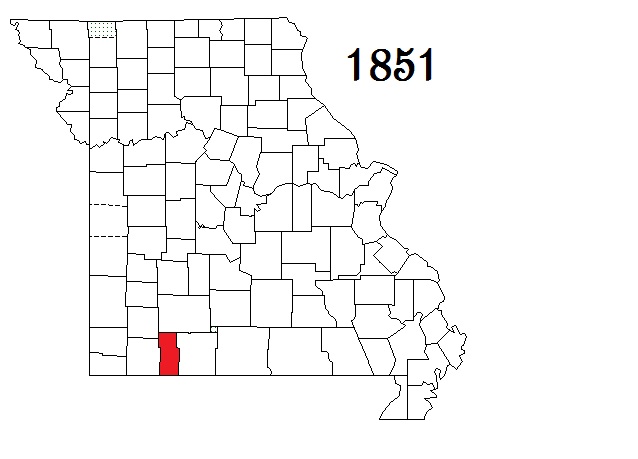
| Vernon County |
Nevada |
1851 |
Bates County |
Official County Site (Clerk, Collector, Recorder)
Genealogy Soc - Historical Socs - Library -
Message Boards #1 - #2 Email Group - E-Group Archives -
First Census - Research Sites #1 - #2 - #3 - #4 Courthouse burned in 1863; records from 1861-65 missing |
GenWeb
GenWeb Archives
|  |
 |
|
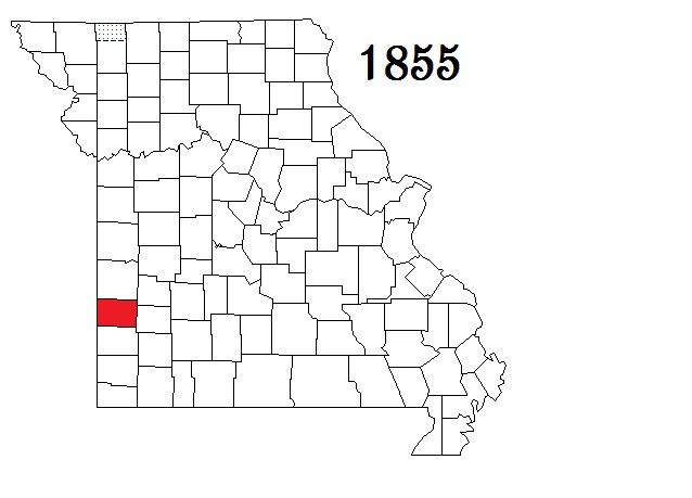
| Barton County |
Lamar |
1855 |
Jasper County |
Official County Site - Courthouse Directory -
Genealogy Soc - Historical Socs - Library -
Message Boards #1 - #2 Email Group - E-Group Archives -
First Census - Research Sites #1 - #2 - #3 - #4 |
GenWeb
GenWeb Archives
|  |
 |
| Maries County |
Vienna |
1855 |
Osage and Pulaski counties |
Courthouse Directory -
Genealogy Soc - None Found - Historical Socs - Library -
Message Boards #1 - #2 Email Group - E-Group Archives -
First Census - Research Sites #1 - #2 - #3 - #4 Courthouse burned in 1868 |
GenWeb
GenWeb Archives
|  |
 |
| Webster County |
Marshfield |
1855 |
Greene County |
Official County Site (Clerk, Collector - , Recorder) -
Genealogy Soc - None Found Historical Socs - Library -
Message Boards #1 - #2 Email Group - E-Group Archives -
First Census - Research Sites #1 - #2 - #3 - #4 Courthouse burned in 1863 & 1880; minor loss |
GenWeb
GenWeb Archives
|  |
 |
|
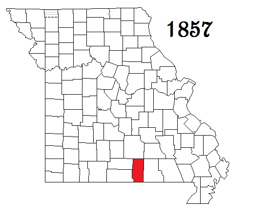
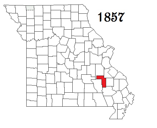
| Douglas County |
Ava |
1857 |
Ozark County |
Courthouse Directory -
Genealogy Soc - Historical Socs - Library -
Message Boards #1 - #2 Email Group - E-Group Archives -
First Census - Research Sites #1 - #2 - #3 - #4 Courthouse burned in 1872 & 1886 |
GenWeb
GenWeb Archives
|  |
 |
| Howell County |
West Plains |
1857 |
Oregon County |
Courthouse Directory - Collector -
Genealogy Soc - Historical Soc - None Found Library -
Message Boards #1 - #2 Email Group - E-Group Archives -
First Census - Research Sites #1 - #2 - #3 - #4 Courthouse burned in 1863; many records lost |
GenWeb
GenWeb Archives
|  |
 |
| Iron County |
Ironton |
1857 |
Madison, Reynolds, St. Francois, Washington and Wayne counties |
Courthouse Directory -
Genealogy Soc - Historical Socs - Library -
Message Boards #1 - #2 Email Group - E-Group Archives -
First Census - Research Sites #1 - #2 - #3 - #4 - #5 |
GenWeb
GenWeb Archives
|  |
 |
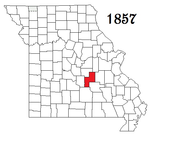
| Phelps County |
Rolla |
1857 |
Crawford County |
Official County Site (Clerk, Collector, Recorder) -
Genealogy Soc - Historical Socs - Library -
Message Boards #1 - #2 Email Group - E-Group Archives -
First Census - Research Sites #1 - #2 - #3 - #4 |
GenWeb
GenWeb Archives
|  |
 |
|
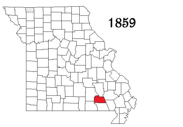
| Carter County |
Van Buren |
1859 |
Oregon, Reynolds, Ripley and Shannon counties |
Courthouse Directory -
Genealogy Soc - Historical Socs - None Found - Library -
Message Boards #1 - #2 Email Group - E-Group Archives -
First Census - Research Sites #1 - #2 - #3 - #4 |
GenWeb
GenWeb Archives
|  |
 |
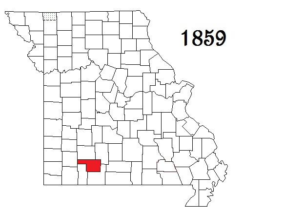
| Christian County |
Ozark |
1859 |
Greene, Taney and Webster counties |
Official County Site (Clerk, Collector - , Recorder )
Genealogy Soc - None Found - Historical Socs - Library
Message Boards #1 - #2 Email Group - E-Group Archives
First Census - Research Sites #1 - #2 - #3 - #4 - #5 - #6 Courthouse burned in 1865 |
GenWeb
GenWeb Archives
|  |
 |
|
| Counties Formed from 1861 through 1870 |
|
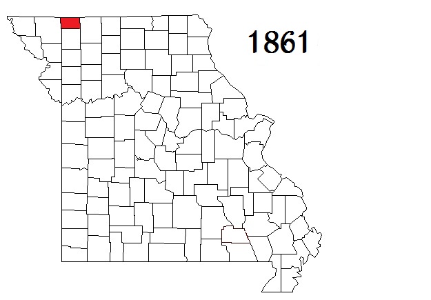
| Worth County |
Grant City |
1861 |
Gentry County |
Official County Site - Courthouse Directory -
Genealogy Soc - Historical Socs - Library -
Message Boards #1 - #2 Email Group - E-Group Archives -
First Census - Research Sites #1 - #2 - #3 - #4 |
GenWeb
GenWeb Archives
|  |
 |
|
|
| Counties Formed from 1871 through 1880 |
|
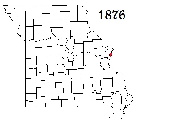
| Saint Louis City |
St. Louis |
1876 |
Created in 1876 when city residents voted to secede from St. Louis County |
Official County Site - City Hall Directory (Collector - , Recorder) http://www.slpl.org/
Genealogy Soc - Historical Socs - Library -
Message Boards #1 - #2 Email Group - E-Group Archives -
Searchable First Census - Research Sites #1 - #2 - #3 - #4 - Obits |
GenWeb
GenWeb Archives
|  |
 |