
| THE NORMAN CONQUESTS OF GREAT BRITAIN & IRELAND | ||
| NOTICE: The contents of this WEB SITE are subject to Copyright ďż˝ 1997-1999, 2003 by David B. Strong. All rights are reserved, including the right to reproduce the contents or portions thereof, in any form. Permission is hereby granted to copy for personal use only limited parts of the written material and of the attached data files contained herein as text material. This material may not be copied except for personal use; and it may not be duplicated and sold, either separately, or as part of a compilation, either in print, on digitalized media such as Compact Disks, or electronically, without the express written consent of the author. This copyright applies to all parts of this site as published on the Internet. |
CHAPTER II | |||
THE NORMAN CONQUESTS OF GREAT BRITAIN & IRELAND | (N:July, 1997) | ||
R: (Wednesday, December 17, 2003) |
The Normans in England:
The Borders:
The Normans in Scotland:
The Isle of Man:
The Normans in Ireland:
Feudalism: It's nature and legal heritage:
End of Page:
Footnotes:
What follows is a brief exploration of the geography and peoples of England. The land was originally largely settled by native Britons, celtic speakers known as the Picts and Celts. These were the various tribal peoples found by Julius Caesar when he invaded England. Later, a composite people, called Anglo-Saxons, but who were in fact an amalgam of Angles, Saxons, and Danes invaded England during the "Dark Ages". They spoke what is now called "Old English", largely a Germanic language, closely related to the language of the peoples of the north German plain. 1
It has been asked in connection with the DNA Study whether there are specific Norman or Scottish, etc., Haplotypes or Haplogroups. I doubt whether anyone has determined what a "Norman" DNA Haplotype looks like. If I had to guess... my suspicion would be that it would not be too different from any one of a half-dozen different "haplogroups". Consider... the Normans who invaded England came from Normandy... but who settled Normandy? The Celts; the Frankish groups which gave rise to the Angles and the Saxons; the Romans (whose legionary troops came from all over the empire); and a few Norse adventurers whose ancestors may have come from Scandinavia, Finland, Russia, etc. In the end, there are a great conglomeration of DNA sources which arrived in England with William the Conqueror, some few of which eventually migrated north to Scotland and helped overthrow the native Scots and then took over. The Norman conquerors' DNA haplogroups may already have been resident in the existing populations of Great Britain ... and who knows whether one's Haplotype is Anglo-Saxon, Scandinavian, Roman, Celtic, or whatever, and when it arrived in Great Britain. What is more important from the standpoint of analyzing the DNA results is the marker patterns of the participants, e.g., whether we can match the haplotype of particular individuals with others well enough to show that they are of the same lineage within an genealogically significant time-frame.
Returning to the historical development of the British peoples, the Angles, Saxons and Jutes had sailed across the North Sea from Denmark and the coastal part of Germany in the year A.D. 449. The native Britons were driven westward, fleeing from the English. The English language arrived in Britain on the point of a sword. In the course of the next 150 years they set up seven kingdoms: Northumbria, Mercia, East Anglia, Kent, Essex, Sussex and Wessex. The dispossessed Britons, called by the Saxons the "Wealas", or foreigners, were pushed into Wales (which derived its name from the name by which it's inhabitants were called) and Cornwall and north toward the Picts in Scotland. 2
Their land was highest in the west and north, with the land surface gradually sinking toward the east and south. A broad distinction can be drawn between the west and east, separated by an intermediate area. There were four areas of high land: 3
1) The southwestern peninsula.
2) Wales, forming the western landward boundary of England.
3) The Lake district, bounded by the Solway Firth, Morecambe
Bay and the valleys of the Eden and the Lune.
4) The Pennine region, stretching from the Scottish border
to the centre of England, running south.
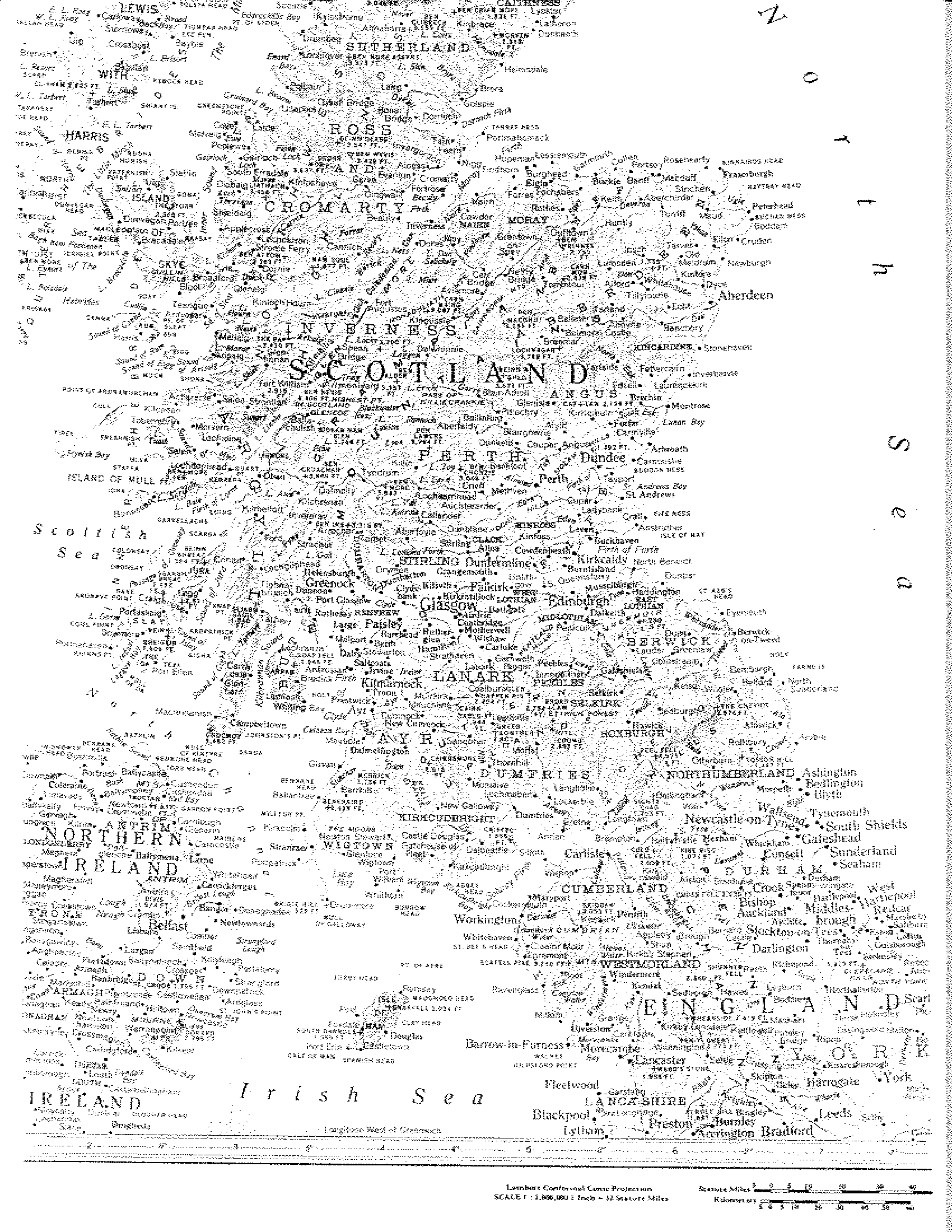
Here is an interesting old wall map, showing England, Wales, and the Isle of Man.
The Welsh Marches: also known as the boundary with Wales. Significant to our present investigation is the location of Salop, or Shropshire, on the western march, or border near Wales. Note the fact that the estate allocated to the Bretton Alan Fitzflaad and his vassals, the L'Estranges, was thus adjacent to the Celtic domain of Wales. There was probably some design in this, with William hoping to insulate the western marches or boundary of his new kingdom with vassals having some thing in common with the Welsh, eg., the Celtic language and an understanding of Celtic culture. See Strange Origins; The Lestranges of Salop; and Lestrange.
The Scottish Marches:We turn now to an examination of the North of England, and the area commonly called "The Borders", refering to the border area between England and Scotland. These too were referred to as "marches"... referring to the military marching distance to be covered by the defending troops on both sides of the border. Included were the Eastern, Middle, and Western marches. The Eastern march centered on Berwick upon Tweed; the Middle march centered on the city and castle of Durham, and the Western march centered on the city of Carlisle. See The Borders. This partial map of the Borders area is from George MacDonald Fraser's book, "The Candlemas Road", ISBN 0 00 271362 4:
The English Western March included the Lake district which occupies the English counties of Cumberland, Westmorland, and north Lancashire, and bounds on Scotland. It forms a roughly circular highland area, the drainage lines of which radiate outward from the center in a series of narrow valleys, the upper parts of which cut deeply into the mountains and the lower widen into the surrounding plain. Except in the towns of the outer border, the Lake district is very thinly populated. There is very heavy rainfall. The district is one of human contrasts, between the simple pastoral life of the high moorlands, and the richer agricultural life centering around the "Border City", Carlisle. 4 See: Cumbria.
About the mid 6th century, the Angles overran most of Caledonia south of the Firth of Forth and east of Strathclyde. Then, in 876-880 A.D. a Danish Viking army divided the whole eastern portion of what is now England into three kingdoms, Northumbria, East Mercia, and East Anglia, collectively referred to as the Danelagh, or Danelaw. The Danelagh did not exist separately for more than about 50 years, but it profoundly affected the later history of the region. It was subsequently distinguished by a large population of free peasant landowners, who undoubtedly represent the descendants of the Danish settlers of the Viking age. The signs of Scandinavian occupation are particularly evident in Yorkshire and the five boroughs of Leicester, Nottingham, Derby, Stamford and Lincoln, in such things as variant forms of English speech and legal customs traceable to the Danish influence. Northumbria was overrun by a fresh invasion of Norwegian Vikings in about 920 A.D. 5
The kingdom of Northumbria remained independent until 1018, when the Northumbrians were defeated in battle by the kingdom of Dalraidia, formed in southeastern Scotland by Picts and Scotis peoples in the 7th century. The united kingdoms, thereafter known as Scotland, embraced all of the lands north of the Solway Firth and the River Tweed and south into present day England. As a result of abortive attempts at expansion south into England about 1138-1149, Northumbria was ceded to the Normans. Much of Scottish history for the next three hundred years revolved on attempts by the Scots to recover Northumbria from the Anglo-Normans. 6
Carlisle was fixed on the western terminus of the wall erected by the Roman Emperor Hadrian across the island from Solway Firth to Newcastle on Tyne in the east, designed by his military engineers to fortify the south against the marauding Picts and Celts of what is now Scotland in the north. In the 10th century, King Edmund, grandson of Alfred the Great, gave Carlisle and Cumberland to Malcomb III, king of the Scots. This event predated the Norman Conquest, and because of this, Carlisle does not appear in the Domesday Book, which of course was prepared on the command of William the Conquerer. In Shakespeare's "Macbeth", he refers to the "prince of Cumberland" as successor to the Scottish throne; this was because Carlisle, Cumberland, and the ancient Kingdom of Strathclyde had earlier been absorbed into the Kingdom of the Scots.
Following the Norman conquest in the south, William (II) Rufus, successor to William the Conqueror, claimed the city as English in 1092, setting up walls and a castle. For the next 650 years, Carlisle knew little peace as it was fought over back and forth by the Anglo-Normans and the Scots. 7
In 1135, King David I of Scotland recaptured Carlisle. He strengthened the castle and died there in 1153. In 1157, English King Henry II reclaimed Carlisle from the Scottish king and the city became permanently English. King Edward I held three parliaments in the castle, and in 1307 a Papal Bull of Excommunication was read against Robert the Bruce of Scotland in the cathedral before Edward set out on his last Scottish campaign. In 1568 Mary, Queen of Scots, fled from Scotland and came to the castle as a guest. She remained as a captive, and from Carlisle, Cumberland, began her slow journey southward toward the execution block. 8
The Pennine footlands in the northeast form a very distinct geographical unit, which may be termed Northeastern England. The region is bounded on the northwest by the Cheviot hills, on the west by the northern Pennine mountains and on the southeast by the north Yorkshire moors. Three important lowland gates leave the region; The Northallerton gate to the south, the Tyne gap to the west and the Berwick gate to the north. The region has exported coal for centuries. It varies from a highly populated, presently industrial coastal patch to the sparsely populated, bleak, sheep-rearing moorlands of the Pennines to the west. 9
Newcastle-on-Tyne takes its name from the Norman castle, built in 1080 by Robert, eldest son of William the Conqueror and replaced between 1172 and 1177. It was an English Borough with its own written constitutions before the reign of Henry II. One of its most important charters was that of King John, granted in 1216, authorizing the burgesses to have a guild merchant. 10
Very little is known of the history of Berwick-upon-Tweed before the Conquest. It was not until the Tweed became the boundary between England and Scotland in the 12th Century that Berwick, as the chief town on that border, became important. After changing hands 13 times it was finally surrendered by Scotland to England in 1482. 11 North of the River Tweed lies Berwickshire, the most southeasterly county of Scotland. 12 Quite evidently, the area was fought over continuously for several hundred years, as the Scots and English each used the natural gateways for invasion routes.
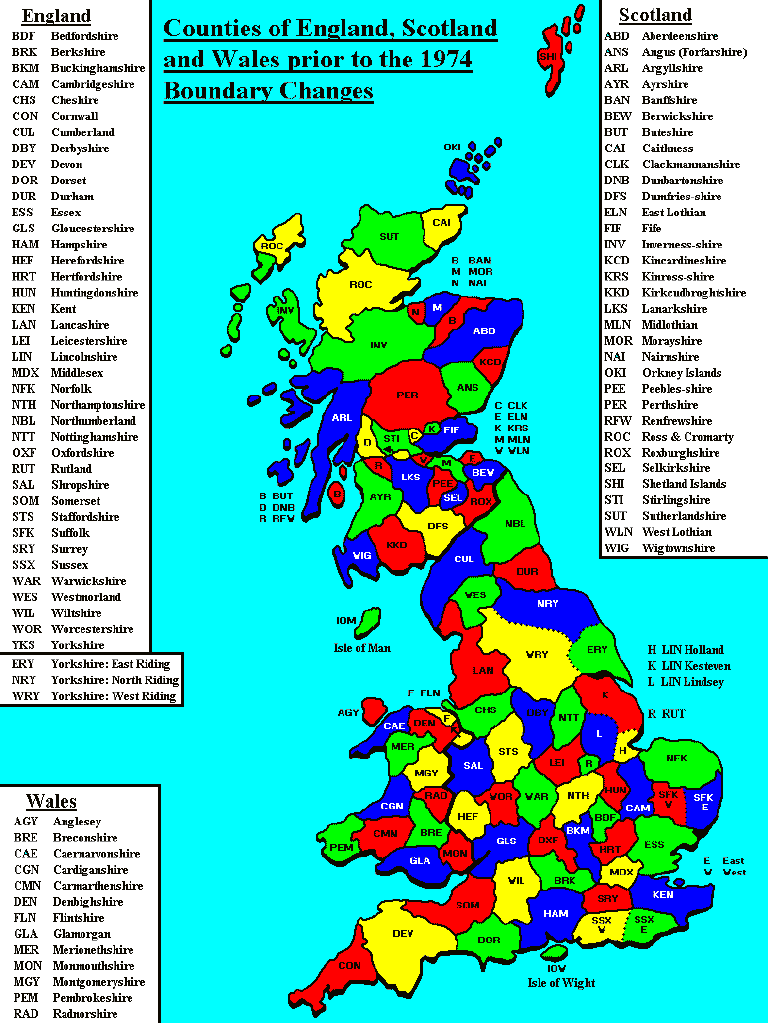
Over the centuries, both England and Scotland were "shired", e.g., divided into counties, for administrative purposes. In 1974 many of the counties were amalgamated. However, many records of genealogical interest to researchers make reference to the "old" counties. Here is a map keyed to show the Old Counties of England and Scotland.
II.2 SCOTLAND:
Scotland is the northernmost of the three
countries constituting Great Britain. It includes the Outer
and Inner Hebrides and other islands off the west coast, and
the Orkney and Shetland islands off the north coast. With
England lying to the south, it is bounded on the north and
west by the Atlantic Ocean and on the east by the North Sea.
The land was known anciently as Caledonia. The name Scotland
originated in the 11th century, when part of it was called
Scotia after a Celtic tribe from what is now Ireland. The
name became firmly established in the 12th and 13th centuries. 13
Physically, Scotland is divided into three structural regions--the Highlands; the central Lowlands, and the southern uplands:
The Highlands are high ground, deeply trenched with valleys and sea lochs. 14 They are inhabited largely by Celtic peoples of various clans, and a predominance of Roman Catholics, dating from conversion of the Celts by St. Columba in the 6th century to the Christian faith; they were later Romanized under the influence of Queen Margaret in the 11th century. 15
The Central Lowlands constitute a broad depression with southwesterly to northeasterly trend lying between the Highland line running from the head of the Firth of Clyde to Stonehaven and the pastoral uplands that stretch from Girvan to Dunbar. Two-thirds of the population of Scotland lives in the Central Lowlands on one-tenth of the total area of the country. The Firth of Clyde on the west and the Firths of Forth and Tay on the east deeply indent the coasts and offer shipping access serving the population centres. 16 The Lowlands today, together with the Southern Uplands, are largely protestant and peopled mostly by Anglo-Saxons, referred to somewhat derisively by the Highlanders as "Sassenachs", or Saxons. 17
The Southern Uplands are a well-defined belt of hilly ground rising with abruptness from the lower tracts bounding them. Geographically it is convenient to include within the southern uplands the whole area between the central plain and the English border. 18 See: Map of Scotland.
As discussed above, in the early years of the 11th century four tribal kingdoms--Scotis, Picts, British, and Angles, were amalgamated in the Kingdom of Scotland. The Scotis were an Celtic Irish tribe inhabiting Dalraidia, the area later known as Argyll. The Angles colonized The Lothians and the counties of Berwick, Selkirk, Peebles and Roxburgh in the late 6th century (Northumbria). The British were Celts occupying the country between the Solway firth and the Firth of Clyde (Cumbria). The Picts were an even earlier tribe who were overwhelmed by the other three tribal colonizations by about the mid-9th century. 19
About 1070 King Malcolm III married an English Saxon princess, Margaret, who sought refuge in Scotland following the Norman Conquest. Margaret's influence, and that of her three sons, Edgar, Alexander I, and David I, (known collectively as the "Margaretson" kings) who each in turn succeeded to the throne, made steady inroads in Anglicizing the country and court. The three brothers came to rely upon Norman help in retaining their thrones, and bent themselves upon converting Celtic Scotland into a feudal kingdom of the Anglo-Norman type. The traditional system of tribal land tenure was abolished during the reign of David I (1124-1153). Claiming universal ownership of the land, he conveyed huge feudal grants in central and southern Scotland to Anglo-Norman and Scottish nobles who thereby became more or less loyal vassals of the crown. 20
The Scots language of the Lowlands was originally a northern variety of English brought there by the Angles who landed in Northumbria and who occupied the southeastern parts of Scotland in the seventh century. The northern English speakers who fled north after William of Normandy's invasion of England in 1066 were welcomed to the Scottish court as refugees from William's "Harrying of the North". The tradition of welcoming immigrants from the South continued into the twelfth century. King David I introduced the "burgh" (a colony or town surrounding a castle) to Scotland. These English speaking burghs marked the beginning of what was to become the Scots English dialect. The ordinary people of the burghs...of Aberdeen, Dundee, Edinburgh, Perth and some ten other centers were English. 21
This helps explain why so many English surnames occur amongst the Lowland Scots, and why the surname "Strang" and "Strong" have a place in Scotland. These English peoples were interspersed with and intermarried with the preexisting Gaels, Picts, and Scots. Compare the geographical locales of the earlier clans, as set out in this "Clan" map of Scotland. It may help explain in part the association of Gallwegian and other southern upland names like Ferguson and McCullough with Strongs in later days. 22
Gradually the whole of the land outside the Highlands came to be held under feudal law, and the landowners were inevitably instruments of the royal policy of anglicization. To the influences of an English court, an English church, and an English system of law and land-tenure were added the effects of English trade. The English burgh was adopted and colonies of English and Flemish merchants settled in Scottish towns. 23
A series of Celtic revolts against the anglicizing policy of the crown occurred in the 12th century and in the beginning of the 13th century but they were all suppressed, sometimes with English help. Before 1286 the organization of Lowland Scotland, from the Moray firth to Tweed and Solway was definitely English, and the English tongue was spoken in a large portion of the area. However, political relations with England were not entirely friendly. The border line was not defined. The Scottish kings claimed Cumberland and Westmorland, and they cherished an ambition of annexing the old kingdom of Northumbria beyond the Tweed. As noted above, raids by Malcomb III had led William the Conqueror to fortify Carlisle. 24
The death of King Alexander III in 1286 led to succession by Margaret, daughter of Eric of Norway, who was Alexander's granddaughter. A civil war almost broke out over the prospect of the succession to the throne by the "Maid of Norway". Intervention by the English King Edward I seemed to prevent the rebellion, but the Maid died enroute to assume her throne. Edward I then asserted his claim to be the feudal overlord of the kingdom of Scotland, with the right to select a vassal as king of Scotland. He asked the Scottish nobles to meet him at Norham-on-Tweed in May 1291, while massing a great English army on the opposite bank of the Tweed. 25
Edward's claim was not entirely repugnant to an assembly consisting largely of Anglo-Norman barons, some of whom held lands in both England and Scotland. The English overlordship was admitted and duly recorded. Edward then made a progress north as far as Perth through the kingdom of his, as yet unidentified, vassal. In November, 1292 Edward I gave his decision in favor of John Balliol. However, within three years the vassal king was in revolt against his overlord. Edward I crushed the revolt in 1296 and forced the Scottish lords to do homage to him in the Ragman Roll of 1296. Over the next forty years a succession of rebellions led to installation of leaders such as William Wallace and King Robert the Bruce by the Scots. Wallace was executed a martyr by the English, and Robert the Bruce died upon his throne without firmly establishing a succession. 26
English king Edward III invited Edward Balliol to attempt to gain the Scottish throne, in a bid to re-establish the son of John Balliol as a vassal king. This eventually led to a crushing defeat of a Scottish army at Halidon hill, near Berwick on July 19,1333, and the town fell into English hands. Edward III then extorted from Balliol a session of most of the south east of Scotland, including the counties of Linlithgow, Edinburgh, Haddington, Berwick, Selkirk, Peebles and Roxburgh. This district passed under the administration of English officials, but Balliol never succeeded in establishing himself as King despite successive invasions of Scotland by his overlord in the years 1334-1337. Then Edward III got involved in a long war with France, and lost interest in defense even of the ceded territory. Gradually the Scottish expelled English garrisons until by 1342 the English had been driven out of a large area in southern Scotland. 27
Particularly interesting about the forgoing history, we find record of involvement by several of the L'Estrange's of Salop in the Scottish intrigues and wars. One Home le Estraunge "was intentive in the king's service in Scotland in 1255. 28 Fulk L'Estrange was summoned repeatedly by the English king to do service against the Scots from March 1298 until April 1323, and it is known he went to Scotland on the King's service in 1299. 29 A relative, Ebles L'Estrange, was also summoned to serve against the Scots in 1327 and again in 1332/3. He died 8 September 1335 in Scotland. 30 Another, John L'Estrange V, was summoned from 1298 to 1308 to serve against the Scots. 31 See Lestrange for genealogical relationships.
According to Prof. George F. Black's well-known book, "The Surnames of Scotland", 32
"William Strange, burgess of Montrose, rendered homage, 1296. Thomas de (? for le) Strang held land in Aberdeen, 1340, and John Strang was elected common councillor there in 1398. Walter Strang was one of an inquest at Forfar, 1438. William Strangh, a Scottish merchant, had license to import Scottish goods into England, 1495. Sir George Strang, a cleric, was notary in Orkney, 1542. Henry Strang is the earliest mentioned schoolmaster in Dysart, 1579. Richard Strange, advocate in Edinburgh, 1555. Strang of Balcaskie, (was) an old family in the East Neuk of Fife. Sir Robert Strange was a distinguished eighteenth-century engraver."
Black goes on to state that Strang is an old surname in the Orkney Islands, and then makes disclosure of the fact that Strangi was an old West Norse given name, but depreciates a Viking root for the name Strang. Contrarily, it seems likely Vikings touched the Orkneys, along with the other Scottish Islands and the Isle of Man with sufficient impact to have planted the name Strang from descendants of several different Strangi's! It is informative to note that the International Genealogical Index (IGI) maintained by the Church of Latter Day Saints shows concentrations of Strongs and Strangs in both Fifeshire and The Orkneys. From all this it might be inferred that the Strangs of western and northern Scotland were descendants of the Vikings. Recent DNA evidence does not show any of the Strang/Strong lineages tested upto late 2003 as having the so-called "Viking" Haplogroup. While this does not exclude the possibility of the progenitors of these families as having been Vikings, neither does it show that they were.
With regard to the Orkney Island Strongs perhaps the following quotation from Charles A. Hanna is enlightening: 33
"...Strong, and Strang (the Strangs of Balcaskie, in Fife, had sent an offshoot into Orkney, which produced our first Scotch engraver. He thought fit to do his name into English, and became Sir Robert Strange)..."
It can be speculated that at least some of the Strangs of Balcaskie, and other Scottish Strangs/Stranges/Strongs, were descended from the Anglo-Norman L'Estrange's who visited Scotland on the English king's service. However, such a line of descent seems quite likely in light of the juxtaposition of the spread of English influence into Lowland Scotland and the record of L'Estranges of note visiting Scotland, doing homage there, serving there, and indeed dying there.
It is also interesting to note the possibility that the
L'Estranges, as Anglo-Norman barons, may well have held estates in Scotland. This seems reinforced by Black's observation that Home le Strange "was intentive in the kings service
in 1255, and that William Strange, burgess of Montrose, did
homage there in 1296. [Editor's Note, The Ragman Roll or "Homage Roll" is a famous listing of the noble landholders of Scotland who were forced to submit in homage to King Edward I of England (sometimes known as the "Hammer of the Scots") in 1296, following a crushing defeat in the Battle of Berwick.]" It should not be lost on the reader that to do homage implied that William Strange had previously held lands or
estates which he might have been allowed to retain by virtue of that feudal pledge. It should also be noted that the late John R. Mayer argued that there is
no proof the Strange families of Scotland were descended
from the Anglo-Norman leStranges; see the John R. Mayer Memorial Web Page
for a discussion under the heading "Significance of his writing"
on the origin and development of the surnames in both England
and Scotland at:
"John R. Mayer message, 6 Jul 1997 06:49:24 -0700
From: "John R. Mayer"
To: [email protected]
Subject: Devolvements Strange"
Recent DNA Study results have tended to support John Mayer's hypothesis. See: DNA Findings (re Hypothesis #21) and see DNA Note #11. However, see also the discussion re possible implications of The Gunpowder Plot concerning Father Thomas Strange and the subsequent loss of Balcaskie by the Scottish Strange family. Hopefully, further research will resolve the question of a possible connection one way or the other.
The IGI shows a considerable concentration of Strongs, Strangs, and Stranges in the Scottish Borders area around Carlisle, in Cumberlandshire, England, and Dumfrieshire, Scotland. There are at least two known lineages descending from the Border Strongs. See Carlisle, Cumbria, and Tynan Abbey. At this point, in light of the DNA Findings and other research it seems unlikely these Strongs may have descended from the barons LeStrange.
II.3 ISLE OF MAN:
The Isle of Man lies in the Irish Sea,
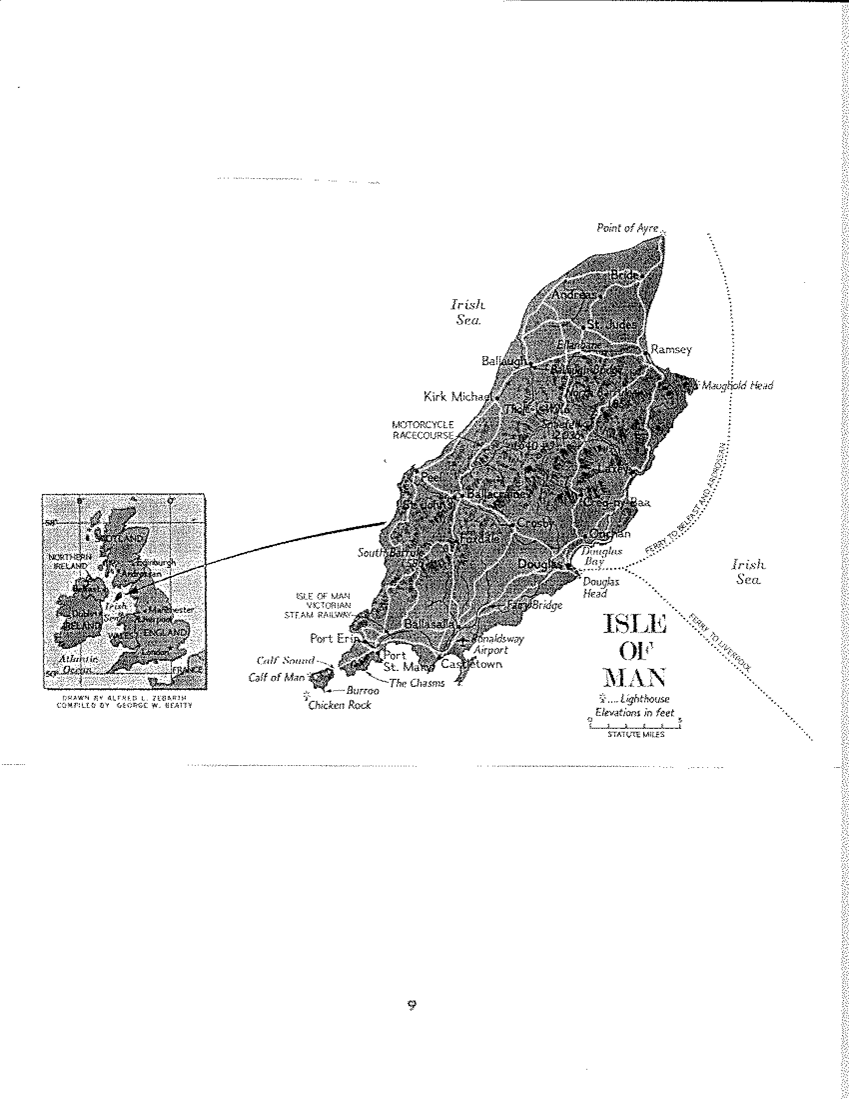
roughly equidistant from England, Scotland, Wales, and Northern Ireland. Refer again to the interesting old wall map, showing England, Wales, and the Isle of Man; note the Isle of Man in the northwestern quarter of the map. See also a Map of the Isle of Man. A largely self-governing community within the
British Commonwealth, the island is 32 miles long by 13 wide,
and has a population of about 60,000. It's highest peak is
Snaefell, at 2,036 feet. From the mountains to the glens and
it's rugged coastal cliffs, it has a mild climate. 34
The Celts arrived from mainland Europe via the British Isles about 500 B.C. Their speech, Manx Gaelic, was a lilting tongue that has all but died out in favor of English. Vikings raided from A.D. 798 35 through the beginning of the 12th century when they began to settle the island. They established a Scandinavian system of government and land ownership which has remained practically unchanged. From the middle of the 12th century, the Manx kings became vassals of either the English or Scottish kings and pawns in the game of war betwixt the two. In the time of King Edward II of England, the Isle of Man was conquered by Robert the Bruce of Scotland. But Edward III won back the Isle of Man for England. 36 In 1405, England's
King Henry IV gave the Isle of Man to the Stanley family, later known as the Earls of Derby, who ruled for more than three centuries. 37
In 1479, Joan LeStrange succeeded her father as Heir to the Barony of Strange of Knockyn, in Salop. Shortly thereafter, by Feb. 1480, she was married to Sir George Stanley, who became 2nd Earl of Derby. By marriage Stanley became Lord Strange. Their heirs inherited the title of Lord Strange. 38 By the mid 18th century, the Stanley family and it's heirs claimed the titles of Duke of Atholl, Earl of Strange, Earl of Derby, Lord Strange, and Baron of Stanley. The Barony of Strange apparently passed out of the Stanley family in 1736, and was assumed by the heirs of the Murray family, who were the Dukes of Atholl. 39 The hereditary family seat of the Dukes of Atholl was in the region of Atholl, in Perthshire, Scotland. 40 In 1972, the 15th Baron of Strange was John Drummond of Megginch, who had at age 65 "left his castle in Scotland and settled on Man, where members of his family had lived for 560 years". 41 See Lestrange.
As Lords of Man, the Stanleys rarely visited the island, but appointed wise governors and sent strong garrisons from Lancashire. Thirteen members of the Stanley family were lords in succession, with two brief interludes. Elizabeth I took over in 1594 when Fernando Stanley died leaving only daughters. The lordship was retained by James I till 1607 when he gave it to the earls of Salisbury; but in 1609 it was returned again to the Stanleys. During the Commonwealth, James, the 7th Earl, the "Great Stanley", left the island in charge of his countess, Charlotte de la Tremoille, whose military commander surrendered it to the Roundheads when the Earl was executed after the battle of Worcester. After the Restoration, the lordship was resumed by his son, Earl Charles. With the death of the 10th earl in about 1764, the male line of the Stanleys came to an end, but the claim of the daughter Charlotte, Baroness Strange and duchess of Atholl, to the Sovereignty of Man was upheld, and in 1764, the Atholls became Lords of Man. 42
The chief feature of the Atholl rule was a gigantic increase in the contraband trade, a serious menace to British revenue, and parliament resolved to suppress it. In 1765, The British Crown bought the Lordship of Man back from the Atholls for the sum of �417,144, as a means of preventing the Manx from smuggling contraband into England. The 4th duke of Atholl remained as governor appointed by the crown. Since then, the King or Queen of England has held the title "Lord of Man", although the island is not actually part of the United Kingdom of Great Britain. The Atholls and their heirs retained their manorial rights and the patronage of the see, and are known as the Barons Strange. 43
II.4 IRELAND:
Ireland is an island to the west of Great
Britain, roughly 300 miles from north to south, and 200 miles
east to west, albeit on an angle which extends over a greater
width. It's minimum distance from Great Britain is 13 1/2
miles between the Mull of Kintyre, Scotland, and Torr Head,
Northern Ireland. The narrowest crossings of St. George's
Channel are about 50 miles in the south and 70 miles in the
north. The central areas of the island are low and the main
upland masses are on the margins: however, the interior is
not a true plain. The uplands do not form a continuous rim
around the island. 44 See: Map of Ireland.
In the far northwest, the mountains of Donegal rise out of the sea, and provide a remote fastness which sheltered many of the native Gaelic Irish from the subsequent invasions from England. Even today, it is one of the strongholds of the Gaelic language, and included in the "Gaeltacht". 45 Note the areas held by the native Irish and the English respectively in the map here:
The dominant factors in the climate of Ireland are its insular position in the north Atlantic Ocean, and the prevailing southwesterly winds. It has a low temperature range of from 15 to -20 degrees F. Rainfall is generally ample, if not excessive. The number of days with rain ranges from 175 to 250, but the showers are usually interspersed with sunny periods. 46
The Norsemen first appeared on the Irish coast in 795. Thereafter there were frequent raids, sometimes far in land. By degrees the Norse took possession of all of the islands of neighboring Scotland, of Caithness, Argyll, Galloway, and the Isle of Mann. In 841, they seized and fortified two ports, Annagassan and Dublin. In the course of the next century, the Norse established permanent settlements in Dublin, Waterford and Limerick. Finally, in 1014, they defeated King Brian Boru, bringing on a period of unsettlement, which basically lasted until about the middle of the 12th century. Ireland was divided into several minor kingdoms, each vying for paramount power. 47
In 1156, the English Pope, Adrian IV, proclaimed that Ireland belonged to King Henry II of England, and his heirs. In 1169, at the invitation of an Irish Chieftain, Dermot MacMurrough, a contingent of Norman knights, led By Baron Richard FitzGilbert de Clare, second Earl of Pembroke and Striguil, nicknamed "Strongbow", invaded Ireland. These Norman knights and their followers founded a Catholic Aristocracy which collectively became known as the "Old English". They spent the larger part of the next four hundred years including the period known as the "War of the Roses" (1455-1485), in an English aristocratic power struggle trying to subdue Ireland from the top down, largely without success. 48
Here is a map showing roughly the areas of Ireland held by the Normans and the native Irish respectively circa AD 1300.
There is clear indication that the LeStranges or other Strongs were a part of Strongbow's contingent. There was a certain Strange or Strong family in Kilkenny, who included Bishops in the Diocese of Ossery in the period 1200-1600. 49 As well, they were clearly involved in administration of the City of Waterford as adherants or vassels of the Earls of Ormond.
In the mid-16th century, Sir Thomas L'Estrange, high sheriff of Norfolk, England (1532), sired sixteen children. The eldest, Nicholas, succeeded at Hunstanton, Salop. Another son, Richard, settled in Ireland, becoming ancestor to the L'Estranges of Moystown, King's County. 50 See John R. Mayer's book "L'Estrange of Moystown" and Patrick Harris' website Lestrange for references and discussion of what is known of the lineage of this family. Speculation arises that this family gave rise to a number of the L'Estrange/Strange surnames in Ireland. Recent DNA evidence suggests that some of the Irish L'Estrange families adopted the name for various reasons. See DNA Note #5. Other DNA evidence suggests the L'Estrange family and the various Strong(e) lineages were not related. See DNA notes 1 & 2.
The struggles of the English to subdue more of Ireland, "beyond the Pale", which was the 20 to 30 mile area around Dublin, developed into a religious war with the advent of the Reformation. The religious orders of Henry VIII (1509-1547) were resisted by the Irish. In 1570, the pope issued a Papal Bull depriving Henry's daughter, Elizabeth I, of her claim to rule over Ireland or England. This gave justification to the Irish resistance to English rule, and tightly linked Catholicism and the Gaelic Irish. It also drew the Gaelic Irish and the Old English together in resistance to the Protestants. 51 Another four hundred years of strife followed, and continues to this day. See Chapters III - Plantations of Ireland; IV - The Reformation, Covenanters and the Civil War ; and V - Tests, Dissent, and the 1689 Revolution.
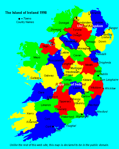
Here is a map showing the modern Irish Counties, keyed to the "Chapman Codes"; and another map showing the modern Irish Counties.
The Normans grafted onto the pre-existing Saxon and Danish laws and customs a series of feudal laws designed to consolidate their hold on the land and peoples of England. The chief relationship was one of lord and vassal. All land tenure was derived from the paramount tenure of the supreme lord or king. Every subordinate holder of land was a tenant and not an owner. The tenure by which a thing of value is held is one of honorable service, not intended to be economic, but rather moral and political in character. 52
There were mutual obligations of loyalty, protection and service binding together all ranks of society from the highest to the lowest. The contract of service between lord and tenant determined all rights, controlling their modification, and formed the foundation of all law. The foundation of the feudal relationship was usually land, but might be any desirable thing, as an office, revenue in money or kind, or the right to collect a toll or operate a mill. In return for the fief, the man became the vassal of his lord; he knelt before the lord and promised him fealty and service. The faithful performance of all the duties he had assumed in homage constituted the vassal's right and title to his fief. So long as these duties were fulfilled, he held the fief as his property, practically and in relation to all tenants under him as if he were the owner. 53
Thus, a knight held his lands by right of "knight's service" to his over-lord, who might be a vassal in turn of further over-lords, and thence upward to the king. The king could call upon all of his vassals, and they upon their vassals, for service according to the nature of the contract whenever affairs of state required. In it's purest and earliest form, the fief was not hereditary, but dependant upon renewal of the oath of fealty by the deceased tenants heirs to the over-lord. This discussion will be brought to mind again in future discussion of the relationships between landlords and tenants in Scotland and Ireland in later chapters. 54
A few other terms and concepts are derived from Saxon and Norman law and are discussed here. The following are quotations from Black's Law Dictionary:
"Burgage: A name anciently given to a dwelling-house in a borough town."
"Burgage-tenure: In English law, one of the three species of free socage holdings; a tenure whereby houses and lands which were formerly the site of houses, in an ancient borough, are held of some lord by a certain rent. There are a great many customs affecting these tenures, the most remarkable of which is the custom of Borough English. Such tenures have (modernly) been abolished (in law)".
"Borough-English: A custom prevalent in some parts of England, by which the youngest son inherits the estate in preference to his older brothers. Abolished as respects enfranchised land by the Law of Property Act (1922); and generally in regard to land by the Administration of Estates Act of 1925."
"socage": A species of tenure, in England, whereby the tenant held certain lands in consideration of certain inferior services of husbandry to be performed by him to the lord of the fee. In its most general and extensive signification, a tenure by any certain and determinate service.... in this sense... it is put in opposition to tenure by chivalry or knight-service... Socage is of two sorts, --- free socage, where the services are not only certain, but honorable; and villein socage, where the services, though certain, are of baser nature..."
"Tithing ... One of the civil divisions of England, being a portion of that greater division called a "hundred". It was so called because ten freeholders with their families composed one (a tithing). It is said that they were all knit together in one society, and bound to the king for the peaceable behavior of each other. In each of these societies there was one chief... who, from his office, was called "teothing-man", now "tithing-man"."
"Tithing-man .... In Saxon law, the head or chief of a tithing or decennary of ten families; he was to decide all lesser causes between neighbors. In modern English law, he is the same as an under-constable or peace-officer."
"Hundred. Under the Saxon organization of England, each county or shire comprised of an indefinite number of hundreds, each hundred containing ten tithings, or groups of ten families of freeholders or frank-pledges. The hundred was governed by a high constable, and had its own court; but its most remarkable feature was the corporate responsibility of the whole for the crimes or defauts of the individual members. The introduction of this plan of organization into England is commonly ascribed to (King) Alfred, but the idea, as well of the collective liability as well as of the division, was probably known to the ancient German peoples, as we find the same thing established in the Frankish kingdom under Clothaire, and in Denmark."
Note, in Eastern England, in the area known as the "Danelaw", the term "Wapentake" is generally used rather than "Hundred".
"Wapentake. In English law, a local division of the country; the name is in use north of the Trent to denote a hundred. The derivation of the name is said to be from "weapon" and "take", and indicates that the division was originally of a military character. Also a hundred court."
"Hundred Court. In English law, a larger court-baron, being held for all the inhabitants of a particular hundred, instead of a manor. The free suitors were the judges, and the steward the registrar, as in the case of a court-baron. It was not a court of record, and resembled a court-baron in all respects except that in point of territory it was of greater jurisdiction..."
"Court-baron... a court which, although not one of record, was incident to every manor, and could not be severed therefrom. It was ordained for the maintenance of the services and duties stipulated for by lords of manors, and for the purpose of determining actions of a personal nature where the debt or damage was under forty shillings..."
This may shed a little light on a few things.... for example the use and scope of the "Hundred" in early Virginia... Some researchers of the Virginia or Southern Strongs will remember "Flowerdew Hundred". This was an early settlement in Virginia... discussed elsewhere by Jim Rolfe and the late Robert T. Strong, Jr. The settlement at Flowerdew Hundred was organized along the lines of the "hundred" as described above, for administrative and for defense purposes. There was an article some years ago in National Geographic describing archealogical findings of a dig at Flowerdew Hundred. The early settlers at Flowerdew Hundred suffered an Indian attack, and many were massacred... Small wonder the early settlers of Virginia found it desireable to organize into "hundreds"! There is some thought that an early member of the Virginia Strong lineage may have been a survivor of the Flowerdew Hundred massacre.
And, hearken to what the manor court was trying to do in requiring George Strong to clean his ditch in a recent account found in Martha Strong's website . IF tythings were still a part of the legal landscape of 16th and 17th century Devon, Dorset and Somerset, the Hundred probably was also, and the manor-court had rather strong precedent behind it for enforcing it's rulings... after all, a society which at one time could hold 100 people liable for the acts of a single individual surely could put considerable peer pressure on that individual!
Just a final side note... remember that Iceland's parliament is called the "Althing". I have always wondered where that came from... the above perhaps sheds a little light. If ten members of a hundred are a "Tything"... a numeric projection of the "thing" to the "ultimate" power or number implies the "ALL-thing"!
A few illustrations may be in order.
In 1997, the late Robert T. "BoB" Strong raised the following question:
"I've been particularly interested in the term "Hundred" as used in the earliest records of the Virginia Colony and elsewhere (e.g., Delaware). There was also a Stanley Hundred, which aroused the interest of this Strong-Stanley descendant. So, if the Hundreds held courts, did the records of these ancient governing bodies get sent back to England to be recorded there? Or were any records of the Hundreds kept at the Shire (county) level? [Virginia originally had seven Shires, if I recall correctly.]"
The answer is probably "no". Note that we said above that the manor court and the hundred court were not "courts of record". What that terminology means is that the said courts were not required to keep transcripts of their procedings. If we are extremely lucky, we might find an estate record kept by the lord of a manor, giving the conclusory result of a particular trial or hearing... and note again that it was the lord of the manor who was holding the "court". He was in effect the "Justice of the Peace", representing the King and the law of the land. It was much later that Justices of the Peace were independantly appointed or elected to such offices.
On the Strong-List, in 1997, Martha Strong discussed a certain Robert Strange, who held a certain tenure in a property in Sussex. A portion of the message is reproduced here:
Hi, everybody.
I hope the following will help. .......Portion Clipped...... The reason I put all these names up here because I have our Stronges called each one of these names. Back then spelling was not uniform it was spelled the way people heard it. When I find a record I do not change the spelling.
EARLY STRONGEs OF CHARD.
1441 - Robert Strange - The chantry of the Holy Trinity - Robert Strange gave a rent and burrage in Chard to this Chantry, 19 Henry VI (1441) (Ref: History of Antiquties of the County of Somerset, by Rev. John Collinson, p.474)
.....Portion Clipped.........
1603 - John Stronge - Tythingman, Wambrook - ( Tythingman - the elected representative of a tithing often coinciding with a manor required to attend the hundred court and present misdemeanors.
.....Portion Clipped.....
Martha"
Just a comment re the above discussion. Don't get misled by the use of the word "rent" into assuming that all the tenures involved were of "leases". "Rent", according to Black's Law Dictionary, "at common law, ... referred to compensation or return of value given at stated times for the possession of lands and tenements corporeal.... " The nature of the right to possession was not necessarily limited to what we modernly call "leases".
As discussed above, under feudal law, the lord paramount of all the land of England was the King, who parcelled out the right "of seizen" to use the land to his various lords and vassals, subject to payment of "Knight-service" as "rent". The land was in turn parcelled out by the lords to sub-ordinate holders who were, at the lowest end of the pyramid, common farmers and town-dwellers "seized of" or holding the land by right of "socage", again subject to the payment of things such as a side of beef, ten sheep, or the like, or rendering of services as "rent".
The nature of the instrument defining the right to hold the land in the case above may have been a "deed of socage-burgage" (my terminology) saying in effect... Robert Strange as the youngest son, inherited the right to hold the house (or land which may have formerly been the site of a house) for his lifetime and thereafter will it (however, note that "persons seized in fee-simple of lands holden in socage tenure were not enabled to devise the same by will until the statute of 32 Henry VIII, passed in 1540"... Black, again, re the Statute of Wills) or deed it to his heirs, or as he seems to have done in this case, deed to the church, giving the church the right not only to the rents generated by the property, but ownership of the property itself.... all subject to paying an overlord "rent" for the feudal right to hold the property.
For more information and additional medieval
terms, you might want to explore the following websites:
Manoral Language Glossary,
and
Feudal Terminolgy Glossary,
both by Prof. T.J. Ray, of the Department of English at Mississippi State University, Oxford, MS.
Suggestions for additions or corrections to this chapter would be welcome. We turn now to Chapter III, "The Plantations of Ireland".
The Normans in England:
The Borders:
The Normans in Scotland:
The Isle of Man:
The Normans in Ireland:
Feudalism: It's nature and legal heritage:
End of Page:
Footnotes:
Footnotes:
A few words about the footnotes in this Webpage are in order. When I first began writing the book that became
"Researching Strong(e) and Strang(e)
in Britain and Ireland", 2nd Edition (Rootsweb) , I was writing for the traditional print format, and intended the documentation
to be in the form of footnotes appearing at the end of each chapter. When I subsequently published the various chapters
on the above website, the footnotes were presented in that format. However, as time went on, I found that it was easier to
present the documentation of particular points immediately in the screen-text. Simply, it was easier to navigate to the documentation
if it was immediately at hand, rather than having to go to the end of the webpage to find the documentation relied upon.
Consequently, as my webpages have been added to and updated there are two different means of documentation provided: the
"on-screen" text variety, and the traditional footnotes.
Anyone curious as to the context in which the material was found may consult further with the references in the Bibliography.
Go to Table of Contents
Go to the Strong Genealogy Network Home Page; while you are there, find other web addresses for members of the Strong Genealogy Network!
Go to the Strong Quest - including the STRONG-List Home Page,
While you are there, be sure to consider subscribing to the Rootsweb Email STRONG List!
See also the Strong Genealogical Forum.
To review some of the discussion on the Strong-List in the past, Go to the Strong List Archives. or go to the Rootsweb Archives.
Help add to our Strong(e)-Strang(e) Roots Database
Copyright �1997, 1998, 2003
David B. Strong. Click for contact information.
