 |
Province of Carolina, 1663 to 1729
Provinces of North & South Carolina, 1729 to 1776
 <---
[See: Province of Carolina, From Wikipedia, the free encyclopedia <---
[See: Province of Carolina, From Wikipedia, the free encyclopedia
|
 |
History Map of United States 1680~1763
Map East of Mississippi River of Inter - Colonial Wars; Kinds of Government in the 13 Colonies at
the close of 1763.
Source: A Genealogical & History Atlas of United States, Pg56)
|
 |
First Lords Proprietors' Map ~ 1671
A new discription of Carolina by the order of the Lords Proprietors.
New description of Carolina by the order of the Lords Proprietors;
Published John Ogilby, c1671
Abstract Covers Atlantic coast from St. Augustine to James Town. Relief shown pictorially.
Oriented with north to right. Includes: "Charles Town, Ashley and Cooper rivers"
Reference William P. Cumming, The Southeast in Early Maps, Third Edition. Chapel Hill: University of
North Carolina Press, 1998.
Map 70.; Philip D. Burden, The Mapping of North America II: A list of printed maps 1671-1700. Herts,
United Kingdom: Raleigh Publications, 2007. Map 435.
|
 |
A New Description of Carolina Province ~ 1676,
A engraved by Francis Lamb, of London, Tho. Basset and Richard Chiswell
|
 |
Lea's New Map of the Carolinas ~ 1695
History of North Carolina, by Samuel A'Court Ashe
1908 Greensboro, North Carolina
|
 |
Lawson's New Map of the Carolinas ~ 1709
Fac-Simile pf a Map of the Inhabited Parts of N. Carolina
Prepared by Ion Lawson, Surveyor General of N.C. 1709
Drawn by Geo. Schroeter, N.Y.
Source: History of North Carolina, by Samuel A'Court Ashe
1908 Greensboro, North Carolina
|
 |
NC and SC Boundary Changes: 1734 - 1835
<---
See: History on Boundary Changes.
|
 |
Chart of his Majesties Province of North Carolina ~ 1738
To His Grace Thomas Hollis Pelham Duke of Newcastle Principal Secretary of State and one of
His Majesties most Honourable Privy Council, &c. This Chart of his Majesties Province of North Carolina
With a full & exact description of the Sea-coast, Latitudes, Capes, remarkable Inlets, Bars, Channels,
Rivers, Creeks, Shoals, depth of Water, Ebbing & Flowing of the Tides, the generally Winds Setting of
the Currents, Counties, Precints, Towns, Plantations, and leading Marks, with directions for all the
navigable Inlets; are Carefully laid down and humbly dedicated, by Your Grace's most humble,
most dutiful, & most Obedient Servant, James Wimble, ca. 1697-ca. 1744., London
|
 |
North Carolina, At the begining of ~ 1740
Showing Approximate County Divisions within Present State Boundaries
Drawn by: L. Polk DENMARK.
Source:
The Formation of the North Carolina Counties 1663 - 1943
by: David L. CORBIT, 1950
|
 |
Map of the Virginia and North Carolina Dividing Line ~ 1752
As drawn by the Chaplain Peter Fontaine Jr., 1859
Historical Note The map on which this facsimile is based on a drawing found at the top of a letter of Peter Fontaine Jr. dated 9 July 1752 in Lunenberg,Virginia. Lunenberg, a chaplain and surveyor, accompanied a team surveying the border between Virginia and North Carolina in 1749.
Reference William P. Cumming, The Southeast in Early Maps, Third Edition. Chapel Hill: University of North Carolina Press, 1998. Map 282.
Related Item From: Hawks, Francis L. History of North Carolina: with maps and illustrations. Vol.II. Fayetteville, N.C.: E.J. Hale & Son, 1859
|
 |
The English Plantations, by Emanuel Bowen, 1754
A Map of the British, "American Plantations" Extending from Boston in New England to Georgia
Incliding all the back Settlements in the respective Provinces as far West as the Mississippi River. by: Eman Bowen, Geog' to his Majesty. with Latitude & Longitude; Rivers & Streams. Source: Chris Campbell Collection
|
 |
Survey, 28 Jan 1754, 422ac, Orange Co., NC.
<---
See: Samuel,1 SARRATT, (1708-1775)
|
 |
Deed 1754, 422ac, Orange Co., NC.
<---
See: Samuel,1 SARRATT, (1708-1775)
|
 |
North Carolina, At the begining of ~ 1760
Showing Approximate County Divisions within Present State Boundaries
Drawn by: L. Polk DENMARK.
Source:
The Formation of the North Carolina Counties 1663 - 1943
by: David L. CORBIT, 1950
|
 |
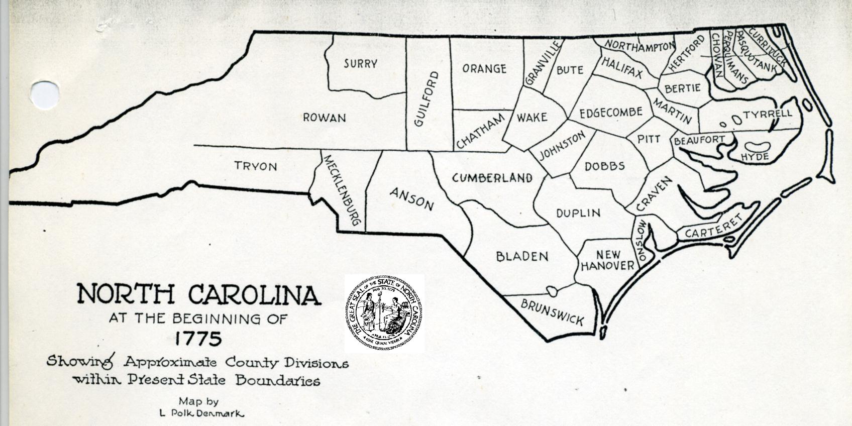
North Carolina, At the begining of ~ 1775
Showing Approximate County Divisions within Present State Boundaries
Drawn by: L. Polk DENMARK.
Source:
The Formation of the North Carolina Counties 1663 - 1943
by: David L. CORBIT, 1950
|
 |
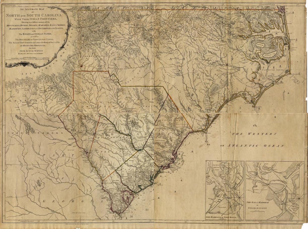
An Accurate Map of North and South Carolina With Their Indian Frontiers ~ 1775
Showing in a distinct manner all the Mountains, Rivers, Swamps, Marshes, Bays, Creeks, Harbours, Sandbanks and Soundings on the Coasts, with The Roads and Indian Paths; as well as The Boundary or Provincial Lines, The Several Townships and other divisions of the Land in Both the Provinces; the whole from Actual Surveys by Henry Mouzon and Others
By: Henry Mouzon, London, England
Printed for Robt. Sayer and J. Bennett, Map and Print-Sellers, No. 53 in Fleet Street. Publish's as the Act directs May 30th 1775.
Map shows North and South Carolina, and part of Georgia. Relief shown by hachures, depth shown by soundings. Depicts towns and villages, mills, roads, courthouses, Quaker meeting houses, and churches. Native American tribes shown include the Meherrin and Tuscarora in northeastern North Carolina, the Catawba south of Mecklenburg County, and the Cherokee in the far western part of the state. Insets show "The Harbour of Port Royal" and "The Bar and Harbour of Charlestown."
|
 |
Western Carolinas: 1775
<---
See: Samuel,1 SARRATT, (1708-1775)
|
 |
Transportation & Settlement in NC.: 1660-1775
|
 |
North Carolina, At the begining of ~ 1780
Showing Approximate County Divisions within Present State Boundaries
Drawn by: L. Polk DENMARK.
Source:
The Formation of the North Carolina Counties 1663 - 1943
by: David L. CORBIT, 1950
|
 |
Western Carolinas: 1780
<---
See: Samuel,1 SARRATT, (1708-1775)
|
 |
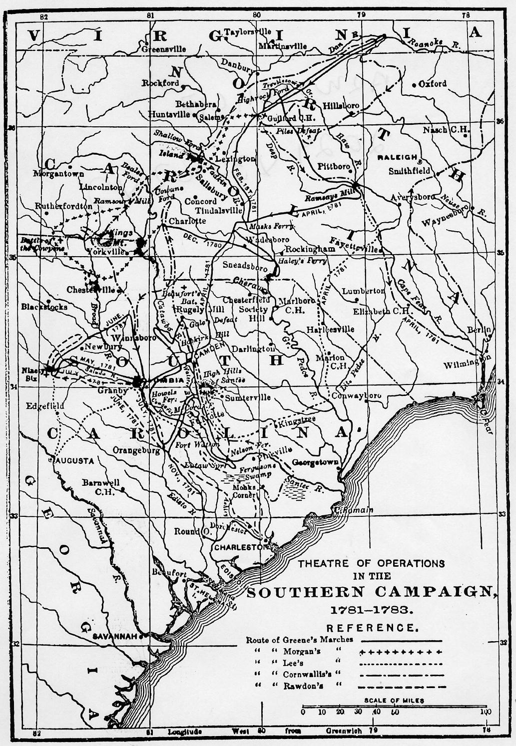
American Revolutionary War 1781-1783
GREEN's Campaigns, Theater of Operations in the South.
|
 |
American Revolutionary War 1781-1783
Route of Greene; Morgan; Lee; Cornwallis and Rawdon's Marches
|
 |
State Claims to Western Lands, 1781
(A History of U.S. , to 1876, NY., Alfred A. Knoph, 1959, Pg166)
|
 |
Western North Carolina, 1783 1880
In the Era of Drovers' Inns & Turnpikes
|
 |
Tennessee, At the begining of ~ 1790
Showing Approximate County Divisions within Present State Boundaries
Drawn by: L. Polk DENMARK.
Source:
The Formation of the North Carolina Counties 1663 - 1943
by: David L. CORBIT, 1950
|
 |
Map of the United States Territories ~ Up to 1800
Dates the Constituation was ratified by new States entering the Union.
Plus list of Presidents of Congress before the Constition went into Operation.
Source: A Genealogical And Historical Atlas of the United States of America, Page 57
|
 |
North Carolina, At the begining of ~ 1800
Showing Approximate County Divisions within Present State Boundaries
Drawn by: L. Polk DENMARK.
Source:
The Formation of the North Carolina Counties 1663 - 1943
by: David L. CORBIT, 1950
|
 |
Western Carolinas: 1800
<---
See: Samuel,1 SARRATT, (1708-1775)
|
 |
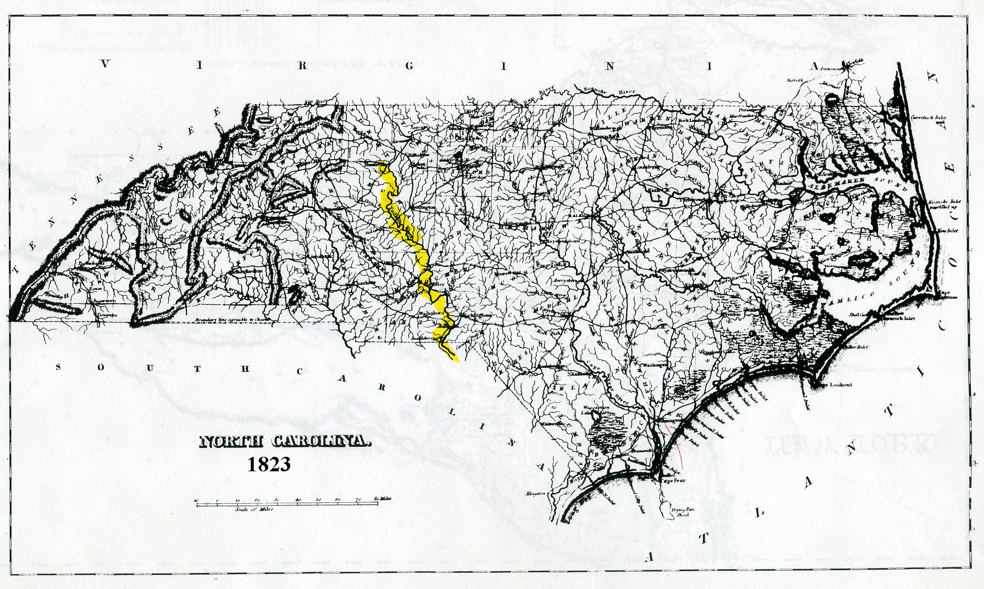
North Carolina ~ 1823
A Complete .... American Atlas of North America and South America, etc to the year 1822
By: H.C. Cary & I. Lea, Phildelphia, Penn. 1823
A Genealogical And Historical Atlas of the United States of America, Page 106
|
 |
Map of North Carolina, By T.G. Bradford, Clerk D.C., Mass. 1838
|
 |
North Carolina, At the begining of ~ 1840
Showing Approximate County Divisions within Present State Boundaries
Drawn by: L. Polk DENMARK.
Source:
The Formation of the North Carolina Counties 1663 - 1943
by: David L. CORBIT, 1950
|
 |
Map of the United States Territories ~ 1800 to 1843
States Admitted to the Union during this Time Period.
Plus a List of Presidents during this Time Period.
Source: A Genealogical And Historical Atlas of the United States of America, Page 57
|
 |
North Carolina, At the begining of ~ 1850
Showing Approximate County Divisions within Present State Boundaries
Drawn by: L. Polk DENMARK.
Source:
The Formation of the North Carolina Counties 1663 - 1943
by: David L. CORBIT, 1950
|


 These records are part of the "Genealogy Computer Package" *** PC-PROFILE *** Volume - II.
Sarratt/Sarrett/Surratt Family Profile©
Compiled and self Published in Oct. 31, 1989 by Paul R. Sarrett, Jr. with
the assistance of my late mother
These records are part of the "Genealogy Computer Package" *** PC-PROFILE *** Volume - II.
Sarratt/Sarrett/Surratt Family Profile©
Compiled and self Published in Oct. 31, 1989 by Paul R. Sarrett, Jr. with
the assistance of my late mother
 Paul R. Sarrett, Jr., President of SFA©
  Feb 15, 2011;