Back to World War One and wars involving the United States - Home Page
Back to Table of Contents - World War I
Maps related to World War I
(Also see: Data on U.S. Army Divisions during World War I)
Note: You may have to reload the web pages several times to get all the images to load because of slow connection speed, servers "timing out" and assorted reasons. Or, just "right click" on them and select "Show Picture."
Table of Contents
- National Army Cantonments (World War I)
- Military Map of the United States and other maps in The Geography Of The Great War
- Military Map of the United States and Canada in The People's War Book
- The Battles for Verdun
- Map Links
National Army Cantonments (World War I)
![]() The text on the image (a page
of text) has been converted to table format to speed up the time it takes to
load this web page.
The text on the image (a page
of text) has been converted to table format to speed up the time it takes to
load this web page.
There were in all sixteen cantonments for the National Army and sixteen cantonments for the National
Guard. Besides these there were officers' training camps and specials camps for the marine corps, the aviation force, and the reception of men whose training was completed and who were being concentrated immediately prior to being put on transports
and sent to the foreign battlefields. A full list of the National Army and the National Guard cantonments with their locations and geographical distribution of the troops which were assigned to each will be of general interest:
National Army Cantonments (Webmaster's note: There are 33 in the list.)
The names borne by the various camps are those of distinguished soldiers of the United States.
| Site | Organization | Troops From -- | Camp Name |
| Ayer, Mass. | 76th Division | Maine, New Hampshire, Vermont, Massachusetts, Rhode Island, and Connecticut. | Camp Devens |
| Yaphank Long Island, N.Y. | 77th Division | Metropolitan portion of New York. | Camp Upton |
| Wrightstown, N.J. | 78th Division | Remainder of New York and Northern Pennsylvania. | Camp Dix |
| Annapolis Junction, Md. | 79th Division | Southern Pennsylvania. | Camp Meade |
| Petersburg, Va. | 80th Division | New Jersey, Virginia, Maryland, Delaware, and District of Columbia. | Camp Lee |
| Columbia, S.C. | 81st Division | Tennessee, North Carolina, South Carolina, and Florida. | Camp Jackson |
| Atlanta, Ga. | 82nd Division | Georgia and Alabama. | Camp Gordon |
| Chillicothe, Ohio. | 83rd Division | Ohio and West Virginia. | Camp Sherman |
| Louisville, Ky. | 84th Division | Indiana and Kentucky. | Camp (Zachary) Taylor |
| Battle Creek, Mich. | 85th Division | Michigan and Wisconsin. | Camp Custer |
| Rockford, Ill. | 86th Division | Illinois. | Camp Grant |
| Little Rock, Ark. | 87th Division | Arkansas, Louisiana, and Mississippi. | Camp Pike |
| Des Moines, Iowa. | 88th Division | Minnesota, Iowa, Nebraska, North Dakota and South Dakota. | Camp Dodge |
| Fort Riley, Kan. | 89th Division | Kansas, Missouri, and Colorado. | Camp Funston |
| Fort Sam Houston, Tex. | 90th Division | Texas, Arizona, New Mexico, and Oklahoma. | Camp Travis |
| American Lake, Wash. | 91st Division | Washington, Oregon, California, Nevada, Utah, Idaho, Montana, and Wyoming. | Camp Lewis |
| Charlotte, N. C. | 26th (old 5) Division | Maine, New Hampshire, Vermont, Massachusetts, Rhode Island, and Connecticut. | Camp Greene |
| Spartanburg, S. C. | 27th (old 6) Division | New York. | Camp Wadsworth |
| Augusta, Ga. | 28th (old 7) Division | Pennsylvania. | Camp Hancock |
| Anniston, Ala. | 29th (old 8) Division | New Jersey, Virginia, Maryland, Delaware, and District of Columbia. | Camp McClellan |
| Greenville, S. C. | 30th (old 9) Division | Tennessee, North Carolina, and South Carolina. | Camp Sevier |
| Macon, Ga. | 31st (old 10) Division | Georgia, Alabama, and Florida. | Camp Wheeler |
| Waco, Tex. | 32nd (old 11) Division | Michigan and Wisconsin. | Camp MacArthur |
| Houston, Tex. | 32nd (old 11) - typo, should be: 33rd (old 12) Division |
Illinois. | Camp Logan |
| Deming, N. Mex. | 34th (old 13) Division | Minnesota, Iowa, Nebraska, North Dakota, and South Dakota. | Camp Cody |
| Fort Sill, Okla. | 35th (old 14) Division | Missouri and Kansas. | Camp Doniphan |
| Fort Worth, Tex. | 36th (old 15) Division | Texas and Oklahoma. | Camp Bowie |
| Montgomery, Ala. | 37th (old 16) Division | Ohio and West Virginia. | Camp Sheridan |
| Hattiesburg, Miss. | 38th (old 17) Division | Indiana and Kentucky. | Camp Shelby |
| Alexandria, La. | 39th (old 18) Division | Louisiana, Mississippi, and Arkansas. | Camp Beauregard |
| Linda Vista, Cal. | 40th (old 19) Division | California, Nevada, Utah, Colorado, Arizona, and New Mexico. | Camp Kearny |
| Palo Alto, Cal. | 41st (old 20) Division | Washington, Oregon, Montana, Idaho, and Wyoming. | Camp Fremont |
| Garden City, Long Island, N. Y. | 42nd Division | Most of the Middle and far Western States. | Camp Mills |
To print out just the chart in table format, click here.
To
see a text file of this table, click here
(.txt) or here
(rtf).
To see a small image (297 KB) of the actual page of text, click here
and to see a larger image (3,789 KB - huge
and 200 dpi), click here.
Source: The United States in the Great War by Willis J. Abbot, Copyrighted in 1919 by Doubleday, Page & Company. Published in 1919 by Leslie-Judge Co., New York, New York; page 42.

Military Map of the United States
Source (posted at this web site): The Geography Of The Great War by Frank M. McMurry, Ph.D., The Macmillan Co., New York. Copyrighted 1919. Page 26-27.
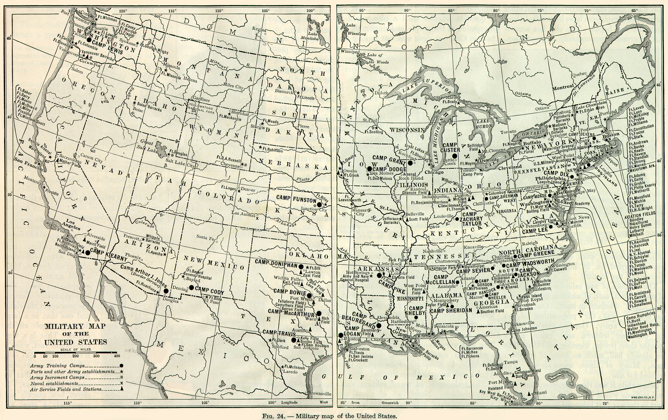 |
| Figure 24. -- Military Map of the United States
(1,408 KB) To see a larger image (5,880 KB), click on it. Key: Army Training Centers (solid dot) Forts and other Army establishments (star) Army Increment Camps (asterisk) Naval establishments (x) Air Services Fields and Stations (solid triangle) |
All maps contained in The Geography Of The Great War by Frank M. McMurry, Ph.D.:
-
Map of the World showing possessions of United States, Great Britain, France and Germany
-
Area of Prussia Compared With All Other German States
-
Kaiser Wilhelm Canal
-
Proposed Berlin to Bagdad Railway
-
Map of the World showing the Nations at War, December 31, 1914
-
The approaches to Paris from the east and northeast.
-
Eastern Battle Front - 1914
-
Eastern Battle Front - 1915
-
Western Battle Front - 1917
-
Map of the World showing the Nations at War - December 31, 1917
-
Military Map of the United States (which is posted above)
-
Western Battle Front - July 15, 1918
-
Map of the World Showing Nations at War - August 1, 1918
Back to Table of Contents - World War I
Military Map of the United States and Canada
(The People's War Book: History, Cyclopaedia and Chronology of the Great War (and Canada's Part in the War) by James Martin and H. S. Canfield; Copyrighted and published in 1920 by The R. C. Barnum Co., Cleveland, Ohio. pages 270 - 271.)
- Northeastern United States (1,306 KB) Connecticut, Maine, Massachusetts, New Hampshire, Rhode Inland and Vermont.
- Eastern United States (1,306 KB) Delaware, Maryland, New Jersey, New York, Pennsylvania and Virginia.
- Southeastern United States (1,585 KB) Alabama, Arkansas, Florida, Georgia, Louisiana, Mississippi, North Carolina, South Carolina and Tennessee.
- Central United States (2,032 KB) Colorado, Illinois, Indiana, Iowa, Kansas, Kentucky, Michigan, Minnesota, Missouri, Nebraska, North Dakota, Ohio, South Dakota, West Virginia and Wisconsin.
- (Southwestern) Southern United States (1,454 KB) Arizona, New Mexico, Oklahoma and Texas.
- Western United States (2,086 KB) California, Idaho, Montana, Nevada, Oregon, Utah, Washington and Wyoming.
- Canada (2,268 KB)
- Entire Military Map of the United States and Canada (7,652 KB; huge!)
Source: The People's War Book and Atlas: Colored Maps and Natural Wonders of the World containing 2 books:
- The People's War Book: History, Cyclopaedia and Chronology of the Great War (and Canada's Part in the War) by James Martin and H. S. Canfield; Copyrighted and published in 1920 by The R. C. Barnum Co., Cleveland, Ohio. 520 pages
- The People's Pictorial Atlas of the World by George Wharton James and Alan H. Burgoyne, and Elmore Elliot Peake; Copyrighted and published in 1920 by The R. C. Barnum Co., Cleveland, Ohio. 392 pages
This was the "Autographed Edition" which was signed by Colonel W. A. Bishop, the World's Ace of Aces.
Back to Table of Contents - World War I
Back to World War One and wars involving the United States - Home Page
The Battles for Verdun
The Battles for Verdun - A map by Otto Kurth, 1916. Huge file size (28130 KB) so only the serious researcher should bother with it. It may "time out" on you unless you have a fast connection. It is only 100 dpi but very, very large. I'm unsure of the source since this map was found in a book that made no reference to it.
Back to Table of Contents - World War I
Map Links
United States Military Academy at West Point
- Atlases
-
WWI ![]()
This page was last updated on 01/30/03 .
http://freepages.military.rootsweb.com/~worldwarone/WWI/Maps/index.html
Comments, suggestions, and specific questions (not general questions or homework assignments, however) may be sent to (I won't be accepting email probably for the rest of the year because I'm very, very busy! I have been swamped with requests.). Questions that may be of interest to the visitors of this site may be posted on the Questions from Web Site Visitors about WWI, World War I web page. I hope that you can help the person asking the question, as well as ask them clarifying questions. Additionally, they may have some information for you. If you are submitting a question, please indicate whether you want you question posted.
Copyright © 2000-2 by P. Darlene McClendon. All Rights
Reserved.
I will not post anything that is still copyrighted. All images and content of
previously copyrighted material was copyrighted prior to 1923. However, my work
in converting this material to suitable web format is copyrighted. Please do not
use without my permission. Teachers/educators may use this material for their
student(s) without having to contact me. The contents of the web site may not be
used for profit in any way.